Huntingdon County Information Page

Borough · Huntingdon County

Orbisonia

8 stories on file, each with its sources. 0.1 square miles of land in the ridge and valley country of central Pennsylvania.

449
Population
2020 Census, P.L. 94-171
0.10 sq mi
Land area
2020 Census gazetteer
643 ft
Elevation
Community reference point, checked against USGS
Borough
Type
GEOID 4206156928

Nearby

Straight-line miles between map centers, 2020 Census boundary file

The founding record

The growth of the town continued and on November 23, 1855, it was incorporated as a borough, with Simon Gratz as the first chief burgess. Orbisonia has two banks, a weekly newspaper, churches of different denominations, a good retail trade with the surrounding country and in 1910 the population was 618. The first school house was a small log structure, but this has been replaced by a modem building. Six miles west of Huntingdon, on the main line of the Pennsylvania railroad, stands the borough of Petersburg, one of the oldest towns in the county. It was laid out on May 21, 1795, by Peter Shoenberger on the tract of land owned by him on the east side of Shaver's creek, opposite the site of old Fort Anderson. Mr. Shoenbergcr, for whom the borough was named, was the first merchant and also kept the first tavern. A postoffice called Shaver's Creek was established there at an early date, with Valentine Wingart as postmaster. Dr. Peter Sevine was the first physician. While the Pennsylvania canal was in operation Petersburg was quite a commercial center and shipping point. Flour and saw mills were established at an early day and the Juniata forge, operated by Hunter & Swoope, was located at the mouth of Shaver's creek. It was one of the pioneer concerns in the manufacture of the famous Juniata charcoal iron. John W. Jordan, ed., History of the Juniata Valley and Its People (New York: Lewis Historical Publishing, 1913) · character 231,171 of the scanned text
In the spring of 1879 Orbisonia and Shade Gap Presbyterian Churches united in calling Rev. J. D. Owens, who is at present serving both churches, Among the early or pioneer members of the Orbisonia Presbyterian Church were John Bollinger, Sr., Mrs. John Bollinger, William Lykely and wife, Mrs. Hooper, Mrs. Jordan, Mrs. Gilliland, Daniel Montgomery and wife, Mrs. T. E. Orbison, Mrs. Bigham, John Bollinger, Jr., and wife, and Mrs. Noble. The pastors who have served this people are Revs. Britton E. Collins, who was for forty-two years a pastor of some church, Shaffer, , , Forbes, Samuel Alexander, Prideaux, and Watson (the two last were supplies), and in the spring of 1879, J. D. Owens, present pastor. Present membership, fifty; value of church property, five thousand dollars. The Sunday-school conCROMWELL TOWNSHIP. 263 nected with this church has a membership of ninety pupils, with an average attendance of seventy, with N. E. Otto superintendent. Methodist Episcopal Church., Just when the first Methodist class was formed in Orbisonia cannot well be ascertained. However, the first Methodist church edifice in this place was of stone, forty-five feet square, and stood on the line between the lands of Thomas T. Cromwell and William Orbison, each one contributing half the land upon whichJ. Simpson Africa, History of Huntingdon and Blair Counties, Pennsylvania (Philadelphia: Louis H. Everts, 1883) · character 1,707,350

Quoted from a work published before 1929 and therefore in the public domain in the United States. Spelling and punctuation are as printed, including nineteenth century spellings of place names. Scanned text carries optical character recognition errors; the character offset is given so the passage can be found and checked in the original.

8 stories

Stories from Orbisonia

Did you know? Cromwell Township is named for a man who was already dead when they named it, and who had put up the first iron furnace west of the Susquehanna.

The county history says the township was erected out of Shirley and Springfield townships in January 1836, and named "in honour of Col. Thomas Cromwell, deceased, who was an early settler and a distinguished and hospitable citizen."

Here is what he had done. In the fall of 1785, Cromwell and George Ashman began taking warrants for vacant land in the valleys around Orbisonia. Together with Edward Ridgely they built Bedford Furnace, which the 1883 county history calls the first iron-smelting establishment west of the Susquehanna. The 1897 Juniata Valley encyclopedia records the same thing separately.

On the tenth of September, 1798, Cromwell advertised in the Pittsburgh Gazette that castings and bar iron were for sale at the Bedford Furnace. Iron out of this county, going to market over the mountains.

By the time the county history was written, the author noted there remained "scarcely a trace" of where that pioneer furnace had stood.

They put his name on the township after he was gone.

Checked against the record. The sourced part is almost word for word right, which is why the one unsourced sentence stands out so badly. Confirmed: Africa 1883 says Cromwell "was erected from Shirley and Springfield townships in January, 1836, and named 'in honour of Col. Thomas Cromwell, deceased, who was an early settler and a distinguished and hospitable citizen.'" January 1836, the two parent townships, and the honorific language all check …

Read the full story, with 3 passages quoted from the county histories →
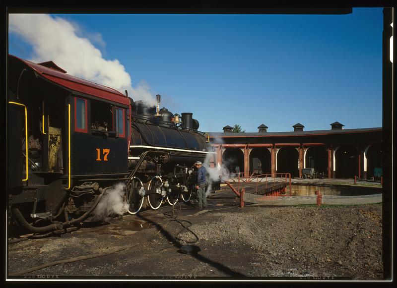
East Broad Top Railroad & Coal Company, Roundhouse, State Route 994, West of U.S. Route 522, Rockhill Furnace
East Broad Top Railroad & Coal Company, Roundhouse, State Route 994, West of U.S. Route 522, Rockhill FurnaceLibrary of Congress, Historic American Buildings Survey / Historic American Engineering Record. No known copyright restrictions. pa3371

The East Broad Top Railroad's shops stand on Meadow Street in Rockhill Furnace, a middle point on a three-foot-gauge line that ran from Mount Union to Alvan. The nomination calls the railroad one of the oldest narrow gauge lines in America, and a 1991 National Park Service inventory of the county's industrial sites records that it was designated a National Historic Landmark in 1964.

The nomination says the East Broad Top Railroad and Coal Company was established in 1871, after the Civil War interfered with an earlier plan to reach the Broad Top coal. Africa's 1883 county history says the company had been organized under an act approved April 16, 1856, that construction began on September 16, 1872, and that the road opened to Robertsdale, its southern terminus, on November 4, 1874. The 1991 inventory says the owners of Rockhill Furnace built the line to reach iron ore and coal in the region, and that it reached its greatest length in 1916 with the extension to Alvan. The road carried timber, sand, rock, general freight and passengers, but coal was its great money-maker: trains hauled it to Mount Union, where it was transferred to the Pennsylvania Railroad. In 1881, Africa records, the road carried 143,449 tons of bituminous coal.

After World War II other fuels began to supplant coal. Passenger service ended in 1953, and on April 16, 1956, the company ran its last train. The purchaser of the entire line preserved five miles of track and six steam locomotives, Mikado types built for the East Broad Top by the Baldwin works of Philadelphia, and began running part of the line as a tourist attraction in 1960. The 1991 inventory names the buyer as the Kovalchick Salvage Company of Indiana, Pennsylvania, and says the town of Orbisonia asked for the reopening to commemorate its bicentennial.

The bulk of the Rockhill yard dates from 1874, including the red brick roundhouse with berths for eight engines and the Armstrong turntable. When the form was written in 1974 the blacksmith shop, foundry and machine and car shops still housed their original machinery, and the foundry was filled with patterns used in making the rolling stock. About 1,400 feet of grade north of Shirleysburg washed out in 1972. Across Meadow Street, the Orbisonia passenger station had its waiting room converted into a gift shop and its freight room into a snack bar.

Decline in the use of coal after World War II forced the East Broad Top to cease operations in 1956. All of its track and rolling stock seemed doomed, but the purchaser of the line generously preserved five miles of the track and six of the steam engines.National Register of Historic Places nomination, East Broad Top Railroad (reference 66000666), 66000666, p. 3 · character 7,078 of the scanned text
Checked against the record. Checked against the National Register nomination text before publication; 3 claims the nomination did not support were removed or corrected.

Open this story on its own page →

Did you know? The flood of 1936 crested over Huntingdon County in the dark, in the small hours of March 18. And on two of our creeks it still did not beat 1889.

The United States Geological Survey had gages running here that week and published every reading two years later. Second feet below is the old way of saying cubic feet of water going past a point every second.

Great Trough Creek near Marklesburg peaked around midnight going into the eighteenth, at about 9,580 second feet. The biggest thing that gage had recorded in the six years before was 2,180.

Shaver Creek near Petersburg reached a stage of 9.32 feet at 3:15 that morning, measured afterward off the flood marks.

Aughwick Creek near Orbisonia crested at 3:30 a.m. at 16,400 second feet, 19.16 feet on the gage.

Standing Stone Creek, three and a half miles up from Huntingdon, topped out around 9:30 a.m. at about 5,070 second feet.

Now the part nobody expects. On Aughwick Creek the Survey records a bigger flood than 1936, and it is June 1889: about 18,400 second feet, 20.5 feet, read off flood marks. On Standing Stone Creek the maximum known stage in the whole record is also 1889, 9.38 feet on the first of June.

Two of our creeks had already seen worse, forty seven years earlier.

Tell us what they said.

Checked against the record. 1. "sweeping away bridges and homes around Huntingdon" NO SOURCE. Removed. 2. "Entire families evacuated from Portstown as floodwaters crept across the countryside." NO SOURCE. Portstown is a real Huntingdon neighborhood and the claim is entirely plausible, but the check could not source it, so it is out. Worth chasing in a local paper later; it is exactly the kind of detail a reader will confirm in a comment. Source…

Open this story on its own page →

Did you know? One of the first storekeepers near Orbisonia was buying his rum by the hogshead from Baltimore in 1773.

George Irvin settled near where Orbisonia now stands within a few years after 1760. He kept store, it is said, in a log storeroom one story high, and traded with the Indians and the early settlers, exchanging wearing material and groceries, boots, shoes, guns and powder for grain and corn.

One of his bills survived. On May 28, 1773, David McLure of Baltimore billed him for one hogshead of molasses and one hogshead of New England rum. McLure wrote that New England rum was getting very scarce, and that flour was low and likely to fall. The 1876 county history noted that a letter took three days to go from what is now Huntingdon County to Baltimore.

Checked and confirmed. CONFIRMED 2026-10-03 against the sources listed: every factual sentence was tied to a verbatim passage and a script confirmed each passage is in its source. Where sources disagreed on a number, the number was left out.

Sources

  1. Milton Scott Lytle, History of Huntingdon County (1876)

Open this story on its own page →

When the Civil War veterans of the southern end of the county organised themselves, they did it under the name of a colonel. The Grand Army of the Republic was the union veterans' organisation, and Col. Isaac Rogers Post, No. 252, was chartered at Orbisonia on 30 May 1882. Africa's county history, printed the following year, records the men who first held its offices.

Col Isaac Rogers Post, No. 252, G. A. R., organized May 30, 1882, at Orbisonia, Pa., with the following officers: C., George S. Baker; S. V. C., William Minnick; J. V. C., A. E. Chilcoat; Adjt., B. F. Chilcoat; Chap., Jacob C. Lockard; Q.M., Henry H. Lahr; O. D., George S. De Bray; O. G., W. B. Snyder.J. Simpson Africa, History of Huntingdon and Blair Counties, Pennsylvania (Philadelphia: Louis H. Everts, 1883) · character 0 of the scanned text

Open this story on its own page →

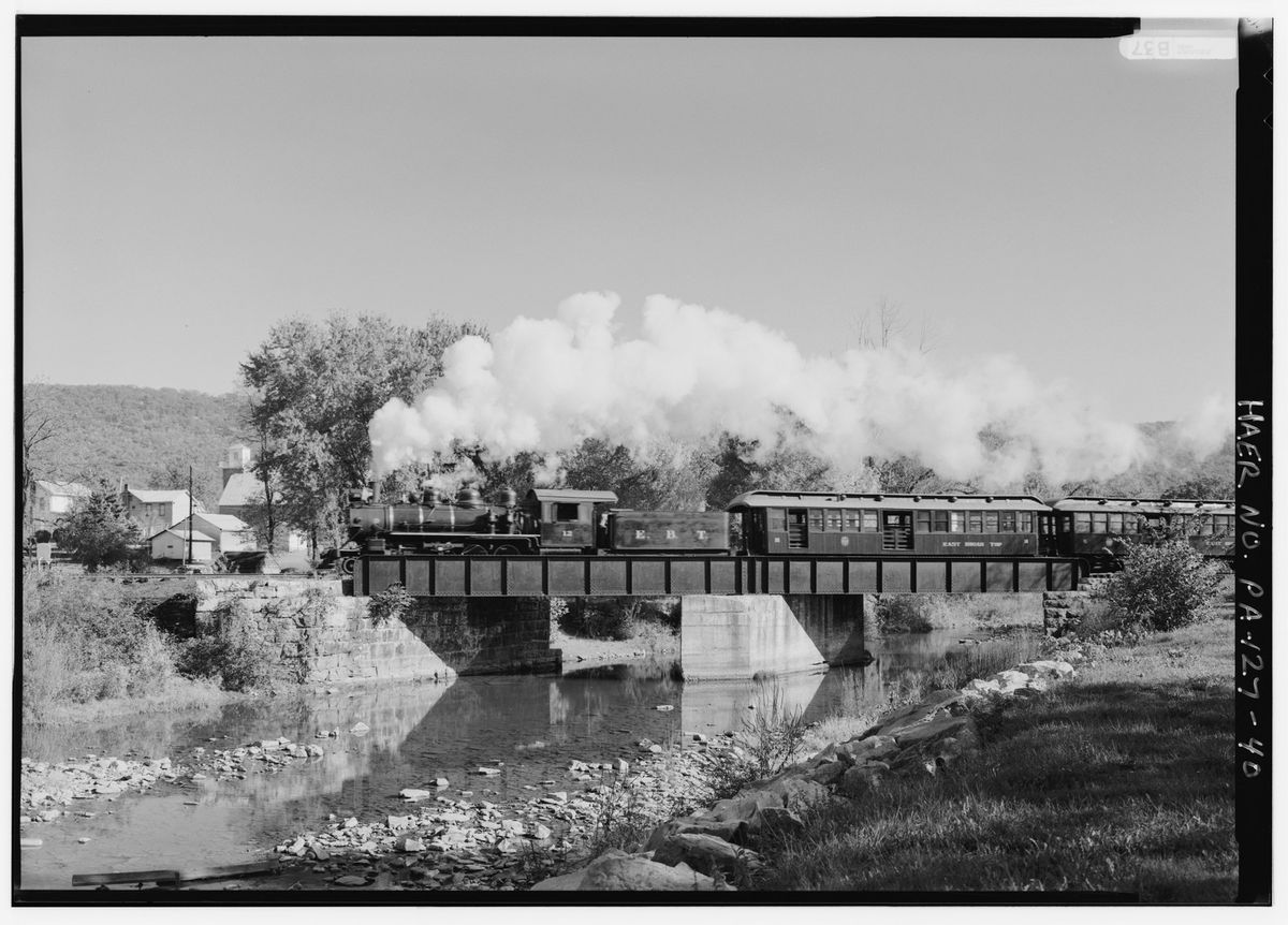
View of Locomotive No. 12 about a quarter mile north of Orbisonia, crossing steel I-beam plate girder bridge after clearing yard at Orbisonia - East Broad Top Railroad
View of Locomotive No. 12 about a quarter mile north of Orbisonia, crossing steel I-beam plate girder bridge after clearing yard at Orbisonia - East Broad Top RailroadLibrary of Congress, Historic American Buildings Survey / Historic American Engineering Record. No known restrictions on images made by the U.S. Government. pa1798.photos.355887p

A quarter of a mile north of Orbisonia, East Broad Top locomotive No. 12 crosses a steel I-beam plate girder bridge after clearing the yard. The survey caption below is the record's own.

Open this story on its own page →

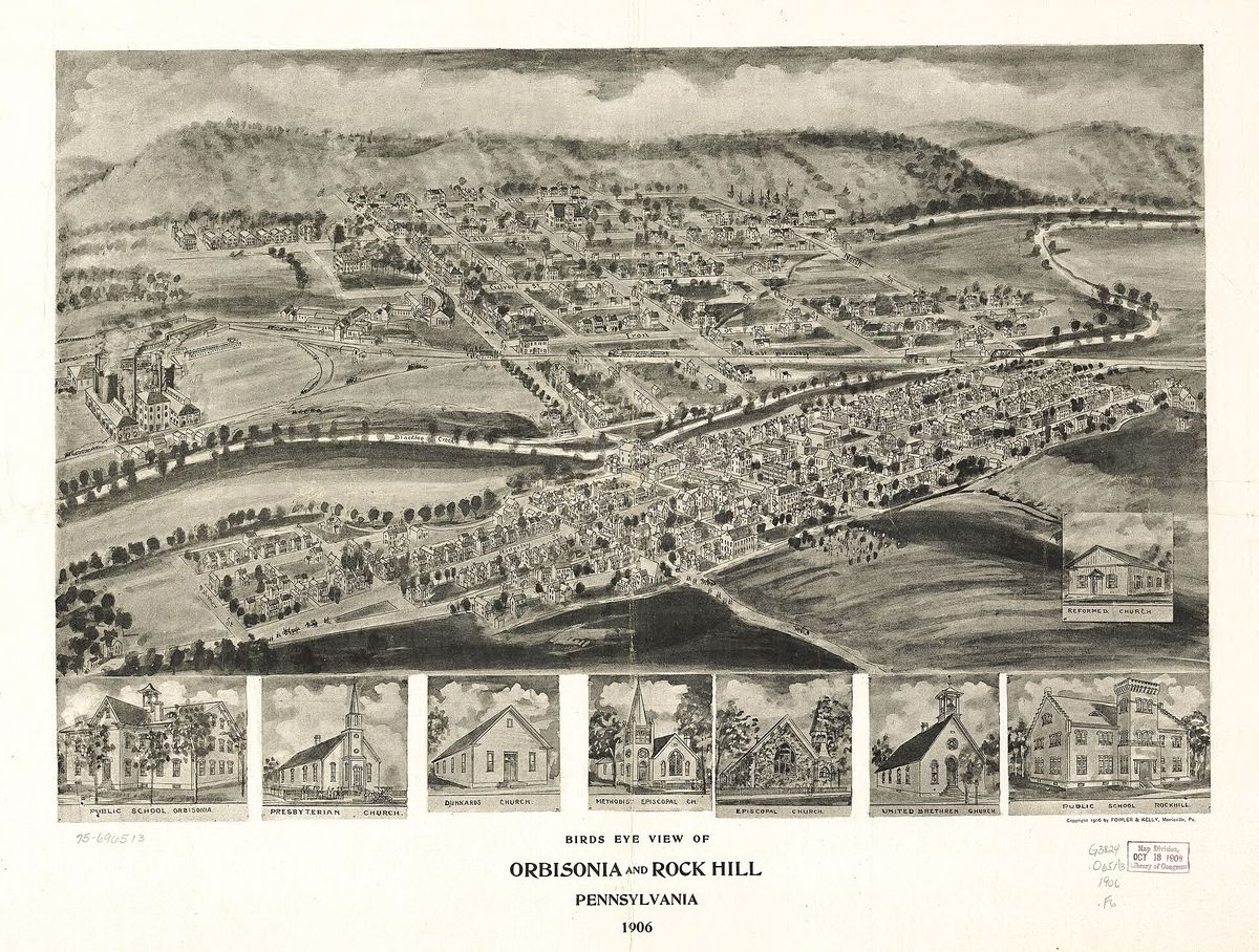
Birds eye view of Orbisonia and Rock Hill, Pennsylvania, 1906. A perspective map, not drawn to scale.
Birds eye view of Orbisonia and Rock Hill, Pennsylvania, 1906. A perspective map, not drawn to scale.Fowler & Kelly, 1906. Library of Congress, Panoramic Maps collection. Public domain. LOC 75696513

Nobody flew over Orbisonia in 1906. The bird's eye view was a commercial art form: an artist walked the streets, drew every building, and then assembled them into a perspective nobody had ever actually seen. Fowler and Kelly made this one of the two boroughs together, and the Library of Congress holds it. It is a perspective map, not drawn to scale, which means the buildings are real and the geometry is persuasion.

Open this story on its own page →

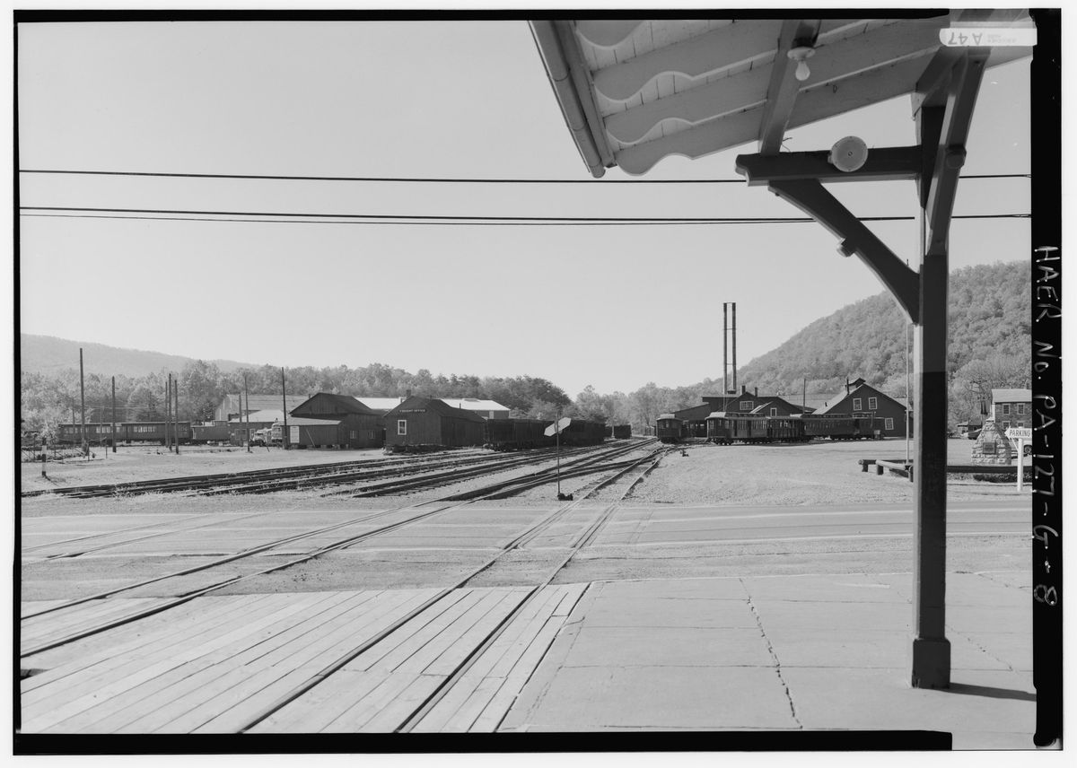
General View Looking South Across Meadow Street (Rte. 994) from Orbisonia Depot Toward the Rockhill Shop Complex - East Broad Top Railroad & Coal Company, Orbisonia Depot
General View Looking South Across Meadow Street (Rte. 994) from Orbisonia Depot Toward the Rockhill Shop Complex - East Broad Top Railroad & Coal Company, Orbisonia DepotLibrary of Congress, Historic American Buildings Survey / Historic American Engineering Record. No known restrictions on images made by the U.S. Government. pa3448.photos.360090p

Looking south across Meadow Street, which is Route 994, from the Orbisonia depot toward the Rockhill shop complex. The East Broad Top was the narrow gauge line that ran from Mount Union south through Orbisonia to the Broad Top coal field, and this is the engineering record's own view of where it stopped in town.

Open this story on its own page →

Where it sits

Alexandria borough: 12 storiesBirmingham borough: 2 storiesBroad Top City borough: 2 storiesCassville borough: 2 storiesCoalmont borough: 2 storiesDudley borough: 2 storiesHuntingdon borough: 36 storiesMapleton borough: 6 storiesMarklesburg borough: 4 storiesMill Creek borough: 4 storiesMount Union borough: 137 storiesOrbisonia borough: 8 storiesPetersburg borough: 3 storiesRockhill borough: 5 storiesSaltillo borough: 5 storiesShade Gap borough: 3 storiesShirleysburg borough: 4 storiesThree Springs borough: 4 storiesBarree township: 6 storiesBrady township: 4 storiesCarbon township: 3 storiesCass township: 2 storiesClay township: 4 storiesCromwell township: 7 storiesDublin township: 5 storiesFranklin township: 10 storiesHenderson township: 6 storiesHopewell township: 5 storiesJackson township: 9 storiesJuniata township: 8 storiesLincoln township: 5 storiesLogan township: 5 storiesMiller township: 4 storiesMorris township: 2 storiesOneida township: 6 storiesPenn township: 4 storiesPorter township: 10 storiesShirley township: 10 storiesSmithfield township: 5 storiesSpringfield township: 5 storiesSpruce Creek township: 7 storiesTell township: 3 storiesTodd township: 5 storiesUnion township: 5 storiesWalker township: 9 storiesWarriors Mark township: 5 storiesWest township: 2 storiesWood township: 13 storiesHuntingdonMount UnionOrbisoniaThree SpringsPetersburgMapletonAlexandriaRockhillBroad Top CitySaltillo
10 or more4 to 91 to 3borough outline