Huntingdon County Information Page

Borough · Huntingdon County

Rockhill

5 stories on file, each with its sources. 0.3 square miles of land in the ridge and valley country of central Pennsylvania.

379
Population
2020 Census, P.L. 94-171
0.29 sq mi
Land area
2020 Census gazetteer
627 ft
Elevation
Community reference point, checked against USGS
Borough
Type
GEOID 4206165496

Nearby

Straight-line miles between map centers, 2020 Census boundary file

The founding record

Rock Hill (postoffice name Rockhill Furnace) was laid out in 1874 across the Black Log creek from Orbisonia. A large number of the early houses were built and owned by the Rockhill Iron and Coal Company. An iron furnace was opened at this place in 1831 by Diven & Morrison. The Winchester furnace was built two or three years later. Rock Hill was incorporated on June 16, 1887, with A. W. Sims as the first chief burgess. It is a station on the East Broad Top railroad and in 1910 reported a population of 504. Saltillo, a station on the East Broad Top railroad in the southern part of the county, was settled in 1796 by Henry Hubbell. On August 20, 1796, Thomas Greer filed for record the plat of "Springville," which occupied the site of Saltillo. A grist mill was built by Henry Hubbell in 1797 and J. & J. C. Brewster were the first merchants. A number of lots were sold to people in Philadelphia and other places, but the lack of transportation facilities caused many of the purchasers to surrender their claims and Springville died a natural death. Some years later Henry Hudson laid out Saltillo, which was incorporated as a borough on December i, 1875, with Samuel McVitty as the first chief burgess. John W. Jordan, ed., History of the Juniata Valley and Its People (New York: Lewis Historical Publishing, 1913) · character 232,915 of the scanned text

Quoted from a work published before 1929 and therefore in the public domain in the United States. Spelling and punctuation are as printed, including nineteenth century spellings of place names. Scanned text carries optical character recognition errors; the character offset is given so the passage can be found and checked in the original.

5 stories

Stories from Rockhill

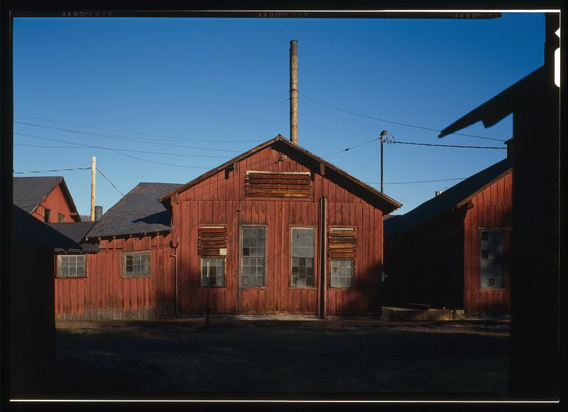
East Broad Top Railroad & Coal Company, Machine Shop, State Route 994, West of U.S. Route 522, Rockhill Furnace
East Broad Top Railroad & Coal Company, Machine Shop, State Route 994, West of U.S. Route 522, Rockhill FurnaceLibrary of Congress, Historic American Buildings Survey / Historic American Engineering Record. No known copyright restrictions. pa3370

The machine shop at Rockhill Furnace is the building the East Broad Top Railroad used to repair its own locomotives. The Historic American Engineering Record filed its photographs and drawings of the shop as HAER PA-127-A; the written history is in the parent report on the shop complex, PA-127, by historian Matthew Kierstead, from documentation begun in 1989 and continued in 1994.

That report says the railroad bought the T. E. Orbison farm in 1872 as the site for its shops, and that the shops grew around an 1867 stone farmhouse that served as the first office. On April 15, 1878, the board of directors recorded that sending locomotives to Baldwin's for repairs had proved expensive and unsatisfactory, and that the Pennsylvania Railroad had agreed to do the work at Altoona. By the summer of 1881 the East Broad Top was buying tools for a new machine shop. The T-shaped core of the wood frame, board-and-batten building, powered by a single boiler, was apparently finished in November or December of 1881 with an engine repair area inside it. In 1882 the board noted that engines could now be repaired in two or three days instead of a month to six weeks.

In what the survey calls the Seibert era the main shop floor was roughly doubled in length, and the survey reads the patent dates on the machines as suggesting a major purchase of new machinery just after the turn of the century. Two 100 horsepower Babcock and Wilcox boilers were installed in that period, feeding a steam engine said to have come from the Rockhill Iron and Coal Company plant, which turns a belt-driven lineshaft system of nearly three dozen separate shafts running machinery in the machine shop, blacksmith shop and foundry. The 1991 county inventory lists the machine shop with a foundry, blacksmith shop, boiler shop, car shop, electrician's shop and supply shed.

The entire holdings of the Rockhill Coal Company, the railroad among them, were sold to the Kovalchick company of Indiana, Pennsylvania, on May 1, 1956. When the survey team looked at the buildings in 1994, the machine shop roof had been elaborately shored up.

Checked against the record. Checked against the survey's written record before publication; 4 claims it did not support were removed or corrected.

Open this story on its own page →

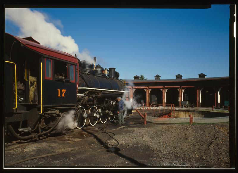
East Broad Top Railroad & Coal Company, Roundhouse, State Route 994, West of U.S. Route 522, Rockhill Furnace
East Broad Top Railroad & Coal Company, Roundhouse, State Route 994, West of U.S. Route 522, Rockhill FurnaceLibrary of Congress, Historic American Buildings Survey / Historic American Engineering Record. No known copyright restrictions. pa3371

The East Broad Top Railroad's shops stand on Meadow Street in Rockhill Furnace, a middle point on a three-foot-gauge line that ran from Mount Union to Alvan. The nomination calls the railroad one of the oldest narrow gauge lines in America, and a 1991 National Park Service inventory of the county's industrial sites records that it was designated a National Historic Landmark in 1964.

The nomination says the East Broad Top Railroad and Coal Company was established in 1871, after the Civil War interfered with an earlier plan to reach the Broad Top coal. Africa's 1883 county history says the company had been organized under an act approved April 16, 1856, that construction began on September 16, 1872, and that the road opened to Robertsdale, its southern terminus, on November 4, 1874. The 1991 inventory says the owners of Rockhill Furnace built the line to reach iron ore and coal in the region, and that it reached its greatest length in 1916 with the extension to Alvan. The road carried timber, sand, rock, general freight and passengers, but coal was its great money-maker: trains hauled it to Mount Union, where it was transferred to the Pennsylvania Railroad. In 1881, Africa records, the road carried 143,449 tons of bituminous coal.

After World War II other fuels began to supplant coal. Passenger service ended in 1953, and on April 16, 1956, the company ran its last train. The purchaser of the entire line preserved five miles of track and six steam locomotives, Mikado types built for the East Broad Top by the Baldwin works of Philadelphia, and began running part of the line as a tourist attraction in 1960. The 1991 inventory names the buyer as the Kovalchick Salvage Company of Indiana, Pennsylvania, and says the town of Orbisonia asked for the reopening to commemorate its bicentennial.

The bulk of the Rockhill yard dates from 1874, including the red brick roundhouse with berths for eight engines and the Armstrong turntable. When the form was written in 1974 the blacksmith shop, foundry and machine and car shops still housed their original machinery, and the foundry was filled with patterns used in making the rolling stock. About 1,400 feet of grade north of Shirleysburg washed out in 1972. Across Meadow Street, the Orbisonia passenger station had its waiting room converted into a gift shop and its freight room into a snack bar.

Decline in the use of coal after World War II forced the East Broad Top to cease operations in 1956. All of its track and rolling stock seemed doomed, but the purchaser of the line generously preserved five miles of the track and six of the steam engines.National Register of Historic Places nomination, East Broad Top Railroad (reference 66000666), 66000666, p. 3 · character 7,078 of the scanned text
Checked against the record. Checked against the National Register nomination text before publication; 3 claims the nomination did not support were removed or corrected.

Open this story on its own page →

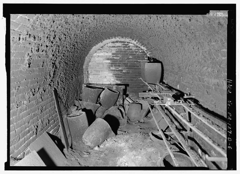
East Broad Top Railroad & Coal Company, Foundry, State Route 994, West of U.S. Route 522, Rockhill Furnace
East Broad Top Railroad & Coal Company, Foundry, State Route 994, West of U.S. Route 522, Rockhill FurnaceLibrary of Congress, Historic American Buildings Survey / Historic American Engineering Record. No known copyright restrictions. pa3373

The foundry at the East Broad Top shops in Rockhill Furnace is where the railroad cast its own iron and brass. The Historic American Engineering Record filed its measured drawings and photographs of the building as HAER PA-127-D, and the written history sits in the parent report on the shop complex, PA-127.

That report cites the board of directors' minute of September 15, 1885, agreeing to erect a foundry at Rockhill. Like the machine shop and blacksmith shop beside it, the foundry was a wood frame building with board-and-batten siding. Inside, the survey describes a shop-built, coke-fired iron melting cupola driven by a twenty-four inch blower, and a natural-draft crucible furnace for melting brass, used for non-ferrous castings and locomotive brasses. In what the survey calls the Seibert era the foundry was greatly expanded: a pattern shop was built north of the coal-fired core oven, and a two-story charging deck was added at the south end, with a pneumatic crane and storage bins above and a casting tumbler and iron scrap bin below. The survey singles out an 1878 wooden-frame foundry crane made by Perrottet and Hoyt as one of the oldest pieces of original equipment on the site.

The Library of Congress record for the building says it has not operated since the East Broad Top stopped running in 1956 and remains in essentially original condition.

The foundry cast for more than the railroad. It supplied castings to the Rockhill Iron and Coal Company mines, and the survey found tagged patterns on the patternmaker's bench for outside customers, among them a pulley pattern for the Pennsylvania Glass Sand Company at Mapleton, near Mount Union, and a simple farmer's plow blade.

Checked against the record. Checked against the survey's written record before publication; 3 claims it did not support were removed or corrected.

Open this story on its own page →

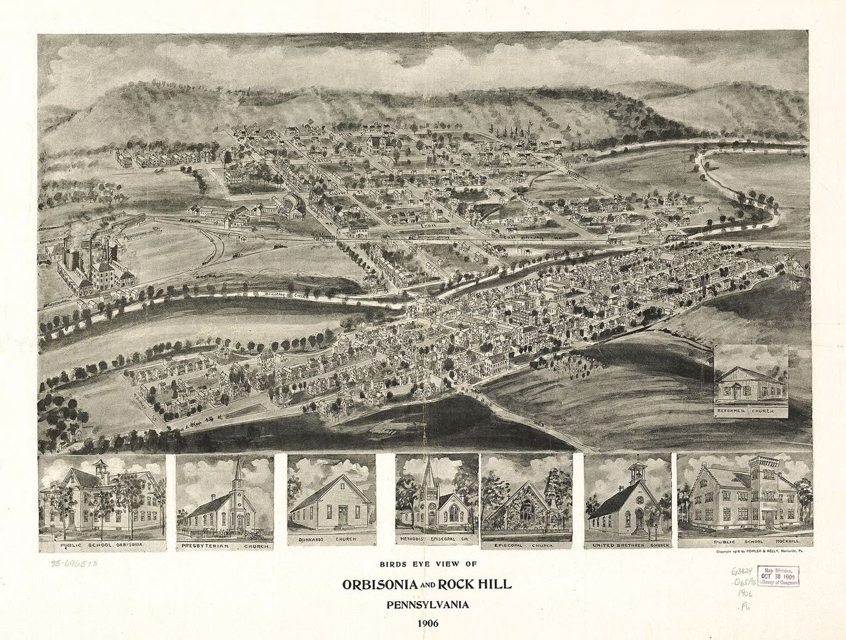
Birds eye view of Orbisonia and Rock Hill, Pennsylvania, 1906. A perspective map, not drawn to scale.
Birds eye view of Orbisonia and Rock Hill, Pennsylvania, 1906. A perspective map, not drawn to scale.Fowler & Kelly, 1906. Library of Congress, Panoramic Maps collection. Public domain. LOC 75696513

Nobody flew over Orbisonia in 1906. The bird's eye view was a commercial art form: an artist walked the streets, drew every building, and then assembled them into a perspective nobody had ever actually seen. Fowler and Kelly made this one of the two boroughs together, and the Library of Congress holds it. It is a perspective map, not drawn to scale, which means the buildings are real and the geometry is persuasion.

Open this story on its own page →

From the county histories, on Rockhill borough. The passage below is printed exactly as it appears in 1883, including the spelling of the day and the errors the scanner made. It has not been rewritten, summarised or added to.

From the west are several small streams flowing into Aughwick Creek, the largest of which is Old Woman's Run, which empties into the Aughwick a little below the mouth of Black Log. The East Broad Top Railroad passes through the township nearly northeast and southwest, alongside the borough of Orbisonia, and through the town of Rock Hill. There are under the surface of Cromwell township large quantities of iron ore, both hematite and fossil, principally owned by the Rock Hill Iron and Coal Company, whose furnaces are located just outside the borough of Orbisonia. The farming lands of this township, scattered as they are through the small valleys, are susceptible of a high state of eultivation, and upon some are raised large crops of corn, wheat, oats, and potatoes. Early Settlers and Pioneer Incidents. , This township being on the old path from the lower Susquehanna to the Ohio country, and a portion of the gap or gateway through which many of the pioneers to the then far-off West journeyed, it would naturally attract the attention of some of the pilgrims in search of future homes. Of this class were ` THE CLUGAGE FAMILY., This family of pioneers settled in Black Log, which was sometimes called Horse Valley, about the year 1763, and consisted of Robert, the father, who died a few years thereafter, and sons named respectively Robert, George, Thomas, Francis, James, and Gaven, each of whom became owners of land in the valley between the Shade and Black Log Gaps.J. Simpson Africa, History of Huntingdon and Blair Counties, Pennsylvania (Philadelphia: Louis H. Everts, 1883) · character 1,637,971 of the scanned text

Open this story on its own page →

Where it sits

Alexandria borough: 12 storiesBirmingham borough: 2 storiesBroad Top City borough: 2 storiesCassville borough: 2 storiesCoalmont borough: 2 storiesDudley borough: 2 storiesHuntingdon borough: 36 storiesMapleton borough: 6 storiesMarklesburg borough: 4 storiesMill Creek borough: 4 storiesMount Union borough: 137 storiesOrbisonia borough: 8 storiesPetersburg borough: 3 storiesRockhill borough: 5 storiesSaltillo borough: 5 storiesShade Gap borough: 3 storiesShirleysburg borough: 4 storiesThree Springs borough: 4 storiesBarree township: 6 storiesBrady township: 4 storiesCarbon township: 3 storiesCass township: 2 storiesClay township: 4 storiesCromwell township: 7 storiesDublin township: 5 storiesFranklin township: 10 storiesHenderson township: 6 storiesHopewell township: 5 storiesJackson township: 9 storiesJuniata township: 8 storiesLincoln township: 5 storiesLogan township: 5 storiesMiller township: 4 storiesMorris township: 2 storiesOneida township: 6 storiesPenn township: 4 storiesPorter township: 10 storiesShirley township: 10 storiesSmithfield township: 5 storiesSpringfield township: 5 storiesSpruce Creek township: 7 storiesTell township: 3 storiesTodd township: 5 storiesUnion township: 5 storiesWalker township: 9 storiesWarriors Mark township: 5 storiesWest township: 2 storiesWood township: 13 storiesHuntingdonMount UnionOrbisoniaThree SpringsPetersburgMapletonAlexandriaRockhillBroad Top CitySaltillo
10 or more4 to 91 to 3borough outline