Huntingdon County Information Page

Township · Huntingdon County

Cromwell

7 stories on file, each with its sources. 50.8 square miles of land in the ridge and valley country of central Pennsylvania.

1,478
Population
2020 Census, P.L. 94-171
50.84 sq mi
Land area
2020 Census gazetteer
Township
Type
GEOID 4206117280

Nearby

Straight-line miles between map centers, 2020 Census boundary file

The founding record

Cromwell township was taken from the townships of Shirley and Springfield and was organized in January, 1836. It was named for Thomas T. Cromwell, who was one of the early manufacturers of iron in Huntingdon county, and who served two terms in the lower house of the state legislature. On the north it is bounded by Shirley township; on the east by Shade mountain, which separates it from Dublin and Tell townships ; on the south by Clay and Springfield, and on the west by Jack's mountain, which marks the line between it and Cass township. The principal stream is the Aughwick creek, which flows through the township from south to north. One of the first white men to locate in the township was George Irvin, who, as early as 1760, had a log store near where Orbisonia now stands and was engaged in trading with the Indians. The Cluggage family came soon after Irvin and Captain Robert Cluggage served with distinction in the Continental army in the Revolutionary war. Two boroughs , Orbisonia and Rockhill , are located in the township, both on the line of the East Broad Top railway, and there are several small villages. Cromwell township is not without its story of hidden treasure. For many years the rumor has been current that Captain Jack, the eccentric character mentioned in another chapter, was once closely pursued by Indians at a time when he bore a heavy bag of gold and silver. John W. Jordan, ed., History of the Juniata Valley and Its People (New York: Lewis Historical Publishing, 1913) · character 181,736 of the scanned text

Quoted from a work published before 1929 and therefore in the public domain in the United States. Spelling and punctuation are as printed, including nineteenth century spellings of place names. Scanned text carries optical character recognition errors; the character offset is given so the passage can be found and checked in the original.

7 stories

Stories from Cromwell

Did you know? Cromwell Township is named for a man who was already dead when they named it, and who had put up the first iron furnace west of the Susquehanna.

The county history says the township was erected out of Shirley and Springfield townships in January 1836, and named "in honour of Col. Thomas Cromwell, deceased, who was an early settler and a distinguished and hospitable citizen."

Here is what he had done. In the fall of 1785, Cromwell and George Ashman began taking warrants for vacant land in the valleys around Orbisonia. Together with Edward Ridgely they built Bedford Furnace, which the 1883 county history calls the first iron-smelting establishment west of the Susquehanna. The 1897 Juniata Valley encyclopedia records the same thing separately.

On the tenth of September, 1798, Cromwell advertised in the Pittsburgh Gazette that castings and bar iron were for sale at the Bedford Furnace. Iron out of this county, going to market over the mountains.

By the time the county history was written, the author noted there remained "scarcely a trace" of where that pioneer furnace had stood.

They put his name on the township after he was gone.

Checked against the record. The sourced part is almost word for word right, which is why the one unsourced sentence stands out so badly. Confirmed: Africa 1883 says Cromwell "was erected from Shirley and Springfield townships in January, 1836, and named 'in honour of Col. Thomas Cromwell, deceased, who was an early settler and a distinguished and hospitable citizen.'" January 1836, the two parent townships, and the honorific language all check …

Read the full story, with 3 passages quoted from the county histories →
Did you know? The man Purdue University is named for was born in Huntingdon County, and he had to quit school at twelve.

John Purdue was born October 31, 1802 in Germany Valley, near Shirleysburg. Purdue's own university archives describe the family plainly: his father Charles worked at a nearby iron foundry, and "the family endured extreme poverty." John was the only son among ten children. He started at a local school at eight and dropped out at twelve to work as a hired hand and help support the family.

In the early 1820s the Purdues moved to Adelphi, Ohio. He taught in a one room schoolhouse, then started selling crops and livestock for his neighbors on commission, then opened a store, then moved to Lafayette, Indiana and kept going. Bank director. Newspaper owner. Railroad organizer.

In 1869, when Indiana was looking to establish its land grant college, he put up $150,000. Among his conditions was that the college carry his name.

Classes started in the fall of 1874. The first commencement was June 16, 1875, and there was exactly one graduate, John Bradford Harper. Purdue gave the address. He died September 12, 1876 and is buried on the campus.

A boy who had to leave school at twelve in Germany Valley put his name on a university.

Checked against the record. Birthplace held up, but not from where the original got it. Neither Africa 1883 nor the 1897 Juniata Valley encyclopedia nor the 1909 Historic Huntingdon contains the name Purdue at all. Wikipedia gives Huntingdon County with NO citation on that sentence. The claim is carried by Purdue University's own Archives and Special Collections: "John Purdue was born in Germany Valley (near Shirleysburg), Pennsylvania on Octob…

Open this story on its own page →

For most of forty years a field in Cromwell township filled up every June with tens of thousands of people and a stage. Creation began in 1979, and not here: the festival's own history opens with “1979, what a year to start a festival in Lancaster, PA,” remembering a fuel crisis so bad that only a fifth of Pennsylvania's filling stations had petrol that weekend. It came to this county five years later. Creation '84, held on 21, 22 and 23 June, was in the organisers' words “the first Creation Festival to be held at the Agape Campground” — the Board of Jesus Ministries had heard the festival needed a larger site and offered the rental of Agape Farm.

It did leave once. After a year at Hersheypark in 1996 the campers said on their surveys that they wanted to go home to Agape, “so, it was back to Shirleysburg we went.”

The festival's website advertised Creation Festival 2023, and then stopped. Snapshots after August 2023 return nothing, and by 2025 the address was serving a hosting placeholder. That is what the record shows; it is not the same as a published announcement, and this page does not claim one.

Checked against the record. Every quoted phrase is from the festival's own history page as archived in November 2012. The venue was placed by coordinates rather than by the postal town: the Agape buildings sit at 40.280, -77.922, which the Census geocoder returns as Huntingdon County, Cromwell township, unincorporated — near Shirleysburg, not in the borough. ⚠ The end of the festival is deliberately left as what the archive shows rather than st…

Open this story on its own page →

The St. Mary's or Shade Gap covered bridge crosses Shade Creek in Cromwell Township, about four and a half miles south of Orbisonia and just off U.S. Route 522. Huntingdon County owns it as Bridge No. 8. The nomination that put it on the National Register in 1980 calls it the only covered bridge remaining in Huntingdon County, and Nancy S. Shedd's 1991 inventory of the county's historic engineering and industrial sites, published by the National Park Service, says the same. That inventory places the bridge across Route 522 from St. Mary's Catholic Church.

It is a single span about 65 feet long on cut stone abutments, with a tin-covered gable roof. The side walls enclose only the lower part of the trusses; the exterior siding runs vertically, the interior horizontally, and the nomination says the open trusswork above the walls is like that of the Bedford County bridges. The year it was built is not settled. The nomination gives one year and the 1991 inventory, which lists the county commissioners' minute book among its sources, gives another, and the two do not agree. The inventory names E. O. Rogers as the contractor and puts the cost at $540.

The nomination's case rests on two things: that the bridge is the county's last, and that its truss is rare. William Howe of Massachusetts patented the Howe truss in 1840. It used iron rods instead of wooden posts as the tension members, which the nomination says eliminated one heavy timber. Howe sold territorial rights to build on his design, and his brother-in-law Daniel Stone held the rights for Pennsylvania. In 1848 Stone began the railroad bridge over the Susquehanna at Rockville, which was in use until 1876; he died in 1863. The nomination says the Howe truss was more commonly used for railroad bridges and appears never to have been a popular system for covered bridges, which is why it counts the four survivors in Pennsylvania as very unusual: McConnell's Mill in Lawrence County, dated 1874, Kintersburg and Thomas Ford in Indiana County, dated 1877 and 1879, and St. Mary's.

Susan M. Zacher of the Pennsylvania Historical and Museum Commission prepared the form, and the bridge was entered in the National Register on March 20, 1980, for engineering and transportation at the local level. In 1982 four steel I-beams replaced the wooden stringers under the deck; the inventory says the planking of the side walls hides them completely.

Checked against the record. Checked against the National Register nomination text before publication; 10 claims the nomination did not support were removed or corrected.

Open this story on its own page →

Did you know? One of the first storekeepers near Orbisonia was buying his rum by the hogshead from Baltimore in 1773.

George Irvin settled near where Orbisonia now stands within a few years after 1760. He kept store, it is said, in a log storeroom one story high, and traded with the Indians and the early settlers, exchanging wearing material and groceries, boots, shoes, guns and powder for grain and corn.

One of his bills survived. On May 28, 1773, David McLure of Baltimore billed him for one hogshead of molasses and one hogshead of New England rum. McLure wrote that New England rum was getting very scarce, and that flour was low and likely to fall. The 1876 county history noted that a letter took three days to go from what is now Huntingdon County to Baltimore.

Checked and confirmed. CONFIRMED 2026-10-03 against the sources listed: every factual sentence was tied to a verbatim passage and a script confirmed each passage is in its source. Where sources disagreed on a number, the number was left out.

Sources

  1. Milton Scott Lytle, History of Huntingdon County (1876)

Open this story on its own page →

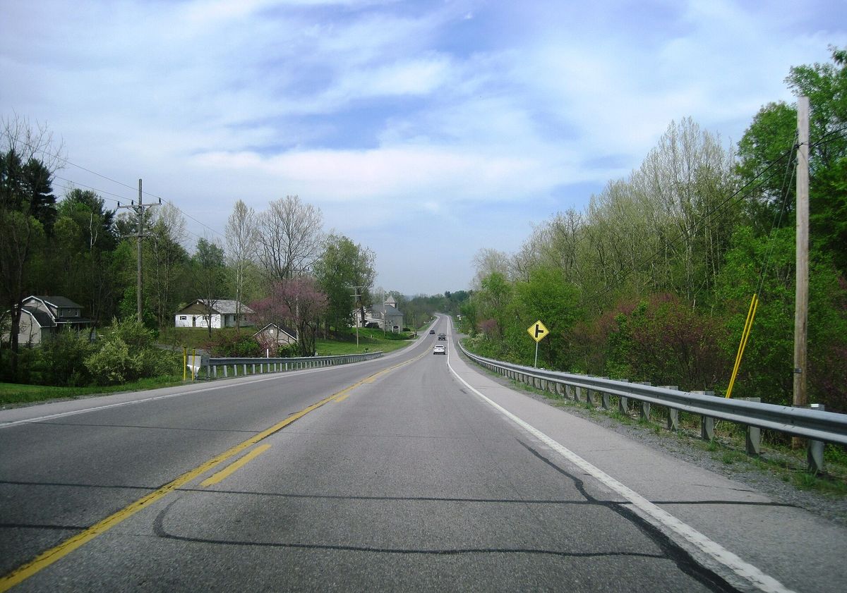
northbound U.S. Route 522 in Cromwell Township, Pennsylvania. Photo taken looking north-northeast between Starr Farm and Covered Bridge Road.
northbound U.S. Route 522 in Cromwell Township, Pennsylvania. Photo taken looking north-northeast between Starr Farm and Covered Bridge Road.Photograph by Mr. Matté, 2024-05-03. Licensed CC BY-SA 4.0; reused with credit, and the same licence travels with any derivative. US 522 nb in Cromwell Twp., PA, May 2024.jpg

U.S. Route 522 running north through Cromwell township, photographed in May 2024 between Starr Farm and Covered Bridge Road.

Checked against the record. Placed by the photograph's own coordinates against the Census geocoder, which returns Huntingdon / Cromwell.

Open this story on its own page →

Did you know? A county history printed in 1876 says a leather bag of silver and gold was hidden on Black Log Mountain and has never been found.

The story, as the history tells it, is that the celebrated Captain Jack is supposed to have hidden the bag on one occasion when he was narrowly pursued, on one side of Black Log Mountain near the narrows or gap. "It is still unfound," the history says.

Checked and confirmed. CONFIRMED 2026-10-03 against the sources listed: every factual sentence was tied to a verbatim passage and a script confirmed each passage is in its source. Where sources disagreed on a number, the number was left out.

Sources

  1. Milton Scott Lytle, History of Huntingdon County (1876)

Open this story on its own page →

Where it sits

Alexandria borough: 12 storiesBirmingham borough: 2 storiesBroad Top City borough: 2 storiesCassville borough: 2 storiesCoalmont borough: 2 storiesDudley borough: 2 storiesHuntingdon borough: 36 storiesMapleton borough: 6 storiesMarklesburg borough: 4 storiesMill Creek borough: 4 storiesMount Union borough: 137 storiesOrbisonia borough: 8 storiesPetersburg borough: 3 storiesRockhill borough: 5 storiesSaltillo borough: 5 storiesShade Gap borough: 3 storiesShirleysburg borough: 4 storiesThree Springs borough: 4 storiesBarree township: 6 storiesBrady township: 4 storiesCarbon township: 3 storiesCass township: 2 storiesClay township: 4 storiesCromwell township: 7 storiesDublin township: 5 storiesFranklin township: 10 storiesHenderson township: 6 storiesHopewell township: 5 storiesJackson township: 9 storiesJuniata township: 8 storiesLincoln township: 5 storiesLogan township: 5 storiesMiller township: 4 storiesMorris township: 2 storiesOneida township: 6 storiesPenn township: 4 storiesPorter township: 10 storiesShirley township: 10 storiesSmithfield township: 5 storiesSpringfield township: 5 storiesSpruce Creek township: 7 storiesTell township: 3 storiesTodd township: 5 storiesUnion township: 5 storiesWalker township: 9 storiesWarriors Mark township: 5 storiesWest township: 2 storiesWood township: 13 storiesHuntingdonMount UnionOrbisoniaThree SpringsPetersburgMapletonAlexandriaRockhillBroad Top CitySaltillo
10 or more4 to 91 to 3borough outline