Huntingdon County Information Page

Across the county line

The places our history runs into that are not in this county.

Kistler is the big one. It sits across the Juniata from Mount Union, its houses were built by the Mount Union Refractories Company, its people worked the same plant, and a good share of the Historic Mount Union collection is about it. It is in Mifflin County, not Huntingdon. So are Newton Hamilton and Wayne Township. They are here because the history is genuinely shared, and they are labelled because filing them silently under a Huntingdon municipality would be wrong.

10 stories

Kistler borough, Mifflin County

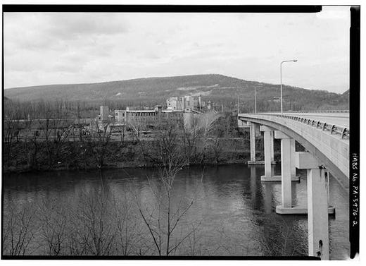
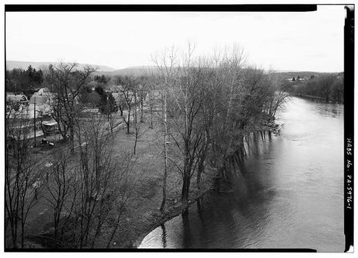
Overall View of Kistler and Juniata River from State Highway Bridge Looking South. - Town of Kistler, Kistler, Mifflin County, PA
Overall View of Kistler and Juniata River from State Highway Bridge Looking South. - Town of Kistler, Kistler, Mifflin County, PALibrary of Congress, Historic American Buildings Survey / Historic American Engineering Record. No known copyright restrictions. pa2824.photos.038900p

Most company towns were laid out by engineers with almost no thought given to how they would feel to live in. Kistler was different, and it is worth being exact about who wanted it different and why.

In 1916 the Mount Union Refractories Company hired John Nolen of Cambridge, Massachusetts, one of the best known town planners in the country, to design a whole village across the river from the plant. The New York firm of Mann and MacNeille drew the buildings. The Sanborn Map Company counted 111 residences in Kistler in 1919: ten built to hold four families each, twenty one double houses and eighty single family houses, in six designs with names instead of numbers.

Nolen wrote the village up himself ten years later in a book called New Towns for Old, and he was plain about the purpose. His philosophy, he said, rested on the belief “that housing is something more than an incident in the life of the worker,” and that good planning could “cultivate a spirit of citizenship and social life among the inhabitants.” Then he explained why that mattered here in particular:

“The population being so largely foreign in its make-up, there is distinct necessity for a lead to be given in the direction of Americanism. This is done in a much better way than by exhortation, by the provision of something tangible, in the form of good living conditions, which more nearly express the ideals of this country.”

The houses had indoor plumbing and bathrooms, and a floor plan with a living room and a separate dining room, which was a middle class arrangement rather than a company house one. The federal surveyors who measured them added the detail that settles the tone of the whole thing: the houses were often so small that the room marked dining room would not take a dining table.

Checked against the record. A NUMBER REPLACED, AND THE SITE'S OWN PAGES ARE WHAT CAUGHT IT. The page said the town was finished in 1917 with ninety four dwellings, seventeen of them two family houses and seventy seven single family houses. That count could not be traced to any document. The survey gives the Sanborn Map Company's count of 1919: 111 residences, ten of them four family buildings, twenty one double houses and eighty single family h…

Open this story on its own page →

View of Brick Plant from Kistler Looking West - Town of Kistler, Kistler, Mifflin County, PA
View of Brick Plant from Kistler Looking West - Town of Kistler, Kistler, Mifflin County, PALibrary of Congress, Historic American Buildings Survey / Historic American Engineering Record. No known copyright restrictions. pa2824.photos.038901p

The third brickyard in town was started by two men who used to run the first one. R. P. M. Davis and Clinton V. Hackman, both former managers for Harbison-Walker, organized the Mount Union Refractories Company and built its plant in 1911 and 1912 on the edge of town along the Juniata. It opened with eight kilns. During the First World War they built twenty one more.

In 1922 the company put up a second plant in Clearfield County and renamed itself U.S. Refractories. In 1930 it merged into North American Refractories. The yard ran until March of 1990, and all but two of its beehive kilns came down after that.

This is the plant seen from Kistler, the town it built.

Sources

  1. HABS PA-5974 p.4
  2. HABS PA-5974 p.7
  3. LOC caption pa2824.photos.038901p

Open this story on its own page →

View of Kistler Company Store and School Building Looking North. Demolished in 1990. - Town of Kistler
View of Kistler Company Store and School Building Looking North. Demolished in 1990. - Town of KistlerLibrary of Congress, Historic American Buildings Survey / Historic American Engineering Record. No known copyright restrictions. pa2824.photos.038904p

Kistler was about as complete a company town as this region produced. The company built and kept up virtually every building in it, along with the roads, the water and the electric.

This was the store and school building, and there is a reason the school was in it. By 1924 Wayne Township was running the Kistler school out of three rented rooms on the second floor, above the company store, and the school board proposed to put up a building of its own. The company president, R. P. M. Davis, objected. The board's choice was a “portable, ready-made building,” and he did not think it “adequate or appropriate” for a town designed by famous architects and planted with thousands of dollars of trees and shrubs. Kistler as a model town, he wrote, was famous, and letters came from all over the United States and from Europe asking about its plans and its history. To put “a squatty, ready-made, ugly school building right in the center of Kistler would be a great misfortune.”

So he stopped it. He had Kistler incorporated as a borough, which took its school administration out of the township's hands, and the classes stayed upstairs in the company's building. The borough of Kistler exists because a brick company did not want a cheap schoolhouse spoiling the view.

Children were taught there until 1936, when a brick school went up at the end of Cedar Street with help from the Works Progress Administration. It is still the Kistler elementary school.

The federal photographer got to the store in time, because the caption on this negative carries four words that end the story: demolished in 1990. A ranch house stands on the site.

Checked against the record. ADDED, and it is the best documented thing on the page: the borough of Kistler was incorporated to keep a school out. The survey sets out the sequence and quotes the company president directly. By 1924 Wayne Township was renting three rooms above the company store for the school. The board wanted a portable, ready-made building of its own. R. P. M. Davis, then president, objected that it was neither adequate nor appr…

Open this story on its own page →

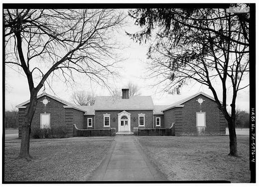
View of Kistler Elementary Looking East-Southeast at End of Cedar Street. Building Constructed by Works Progress Administration
View of Kistler Elementary Looking East-Southeast at End of Cedar Street. Building Constructed by Works Progress AdministrationLibrary of Congress, Historic American Buildings Survey / Historic American Engineering Record. No known copyright restrictions. pa2824.photos.038903p

Kistler Elementary sits at the end of Cedar Street. The federal survey records two things about it that belong together: the brick school in the company town dates to 1936, and the building was put up by the Works Progress Administration.

A company built the houses. The government built the school. The children who filled it were the children of men making brick for steel mills two hundred miles away.

Sources

  1. LOC caption pa2824.photos.038903p (HABS PA-5976)
  2. Shedd 1991, Mount Union Refractories: Company town of Kistler (brick school, 1936)

Open this story on its own page →

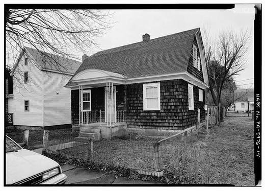
Close View of Vermont Farmhouse-Style Home with Original Porch Roof and Siding, No. 43 Poplar Street. - Town of Kistler, Kistler, Mifflin County, PA
Close View of Vermont Farmhouse-Style Home with Original Porch Roof and Siding, No. 43 Poplar Street. - Town of Kistler, Kistler, Mifflin County, PALibrary of Congress, Historic American Buildings Survey / Historic American Engineering Record. No known copyright restrictions. pa2824.photos.038913p

Not numbers. Names. They are written on John Nolen's own plan for the town, and the federal survey copied them down: Double Valley Farm House, Double Mountain House, Double Capri Villa, Georgian Cottage, Vermont Farm House, and Norman Cottage.

The architects picked those old fashioned forms on purpose. They believed the character of a building could shape the character of the people living inside it, and the families coming to Kistler were going to be a mix of native born Americans, immigrants and African Americans who had never been asked to live the way the company had in mind.

The survey is specific about where those families came from. Kistler's foreign born residents, like Mount Union's, included east European immigrants, and the African American families had been recruited from the country around Saluda, South Carolina. On how they were then distributed through this carefully drawn village, the surveyors chose their words with care, and so will we: although no strict segregation was reported in Kistler, most of the African American families lived on Pine Street.

This one is No. 43 Poplar Street, a Vermont Farm House. Twenty seven of them were built and all but one were still standing when the surveyors counted. The caption notes this one still had its original porch roof and its original siding.

Checked against the record. ADDED, from the survey's own text and footnotes: the African American families in Kistler were recruited from the area around Saluda, South Carolina. That is not a general statement about migration. It names the place they were brought from, and it is the kind of detail a family in this town might still be able to match to a grandparent. THE HEDGE IS THE SOURCE'S OWN AND IT IS REPRODUCED EXACTLY. The survey says “al…

Open this story on its own page →

View of Nos. 96 and 96 Cedar Street Looking North, Examples of Norman Cottages. - Town of Kistler
View of Nos. 96 and 96 Cedar Street Looking North, Examples of Norman Cottages. - Town of KistlerLibrary of Congress, Historic American Buildings Survey / Historic American Engineering Record. No known copyright restrictions. pa2824.photos.038914p

A Norman Cottage sits gable end to the street, one and a half stories, with one roof slope run out long to cover a side porch and a three window bay pushed out of the front. Twenty three were built at Kistler and twenty one were still there when the federal survey counted them.

Kenneth and Edna Cox kept theirs exactly as it was built. No additions, no alterations to the outside. The survey noticed something quiet and human in that. For most of the century it was a mark of getting ahead to modernize a company house. By 1991 the neighbors were asking the Coxes not to touch theirs.

Sources

  1. Shedd 1991, company town of Kistler (Norman Cottage description, 23 built, 21 survive)
  2. HABS PA-5973 pp.39-40 (Kenneth and Edna Cox, interview 10 June 1991)
  3. LOC caption pa2824.photos.038914p

Open this story on its own page →

View of House Looking South. - General Refractories Company, Superintendent'S House, 118 Market Street
View of House Looking South. - General Refractories Company, Superintendent'S House, 118 Market StreetLibrary of Congress, Historic American Buildings Survey / Historic American Engineering Record. No known copyright restrictions. pa2850.photos.038946p

This is 118 Market Street, the General Refractories superintendent's house. It is still there.

The same company owned forty one houses in Mount Union, scattered in four different places. Two rows of gambrel roofed houses along east Water Street and Pennsylvania Avenue. A row of seven, two stories, right up against the plant on Wausau Place. Six frame houses on Shirley Street. And twelve one story shanties across Hill Valley Run on the far side of the plant, in a section the town called Shantytown. Not far off was Mount Union Refractories' own row of shanties, which somebody with a sense of humor had nicknamed Little Kistler.

When the divesting came, the houses that looked like houses were sold to the families in them. The shanties were judged unfit to pass into private hands and were pulled down. One end of the company's housing survived to be photographed. The other end did not.

Sources

  1. LOC caption pa2850.photos.038946p (HABS PA-6003)
  2. HABS PA-5974 p.6 (41 houses in four areas, Shantytown)
  3. HABS PA-5973 p.29 (Little Kistler)

Open this story on its own page →

This is Clinton V. Hackman. Charles H. Welch's history of Mount Union, published in 1909, prints this portrait and captions it “Superintendent Harbison-Walker Brick Plant”.

He did not stay there. The federal survey of Mount Union puts it in one sentence: the third company, Mt. Union Refractories, was organised by two former managers for Harbison-Walker, R. P. M. Davis and Clinton V. Hackman. It was built in 1911 and 1912 on the edge of town along the Juniata and started with eight kilns. During the First World War it built twenty one more.

By November 1916 the Harrisburg Telegraph was naming C. V. Hackman as superintendent of that company, and Davis as its president and general manager. Two men who had worked for Harbison-Walker, running their own plant across town from it.

The company did not keep the name. In 1922 it opened a second plant in Clearfield County and became the U. S. Refractories Company. In 1930 it was merged into North American Refractories, which is the name most people in town still use for that end of the works.

Mount Union Refractories is the company that hired John Nolen to lay out Kistler, the planned town across the river in Mifflin County, for the workers it could not house.

Checked against the record. THIS PAGE CARRIED A CORRECTION THAT WAS ITSELF WRONG, AND IT IS NOW REVERSED. The honest version of what happened matters more than a tidy note, so here it is. The page originally said Hackman “was one of two former Harbison-Walker managers who organized Mount Union Refractories in 1911.” An earlier check cut that sentence for want of a source, cut it from a second page as well, and recorded that nothing supported i…

Read the full story, with 3 passages quoted from the county histories →

View of Double Mountain-Style Houses Looking Southeast on Birch Street. - Town of Kistler
View of Double Mountain-Style Houses Looking Southeast on Birch Street. - Town of KistlerLibrary of Congress, Historic American Buildings Survey / Historic American Engineering Record. No known copyright restrictions. pa2824.photos.038911p

Seven Double Mountain Houses were built in 1917 for workers in Kistler, the company town of Mount Union Refractories across the Juniata River from Mount Union. Only three of the seven were still standing when the federal surveyors counted in 1991. Each duplex stands one and one-half stories tall, distinguished by a rectangular plan, gable roof with pent eaves, a wide shed roof dormer on the front, and double front entrance porches. The Double Mountain House was one of six house types designed for the industrial village by the New York architectural firm Mann and MacNeill under landscape architect John Nolen's town plan. Among all the house types built for Kistler, this one faced the steepest loss.

Checked and confirmed. Published without a source list. Every claim has now been read against the 1991 county industrial survey and holds, including the architectural description and the count of seven built and three surviving. The superlative needed the most work, because saying a thing suffered the worst losses means counting all its rivals: the survey gives all six house types, and the Double Mountain House lost four of seven where the…

Sources

  1. Nancy Shedd, Huntingdon County Historic Engineering and Industrial Sites Inventory (1991), the Kistler entry: ninety-four company-built dwellings in six house types named on John Nolen's plan, designed by Mann and MacNeill of New York; the Double Mountain House described as a one-and-one-half-story duplex, seven built and three surviving. The survey's counts for all six types are what make the "steepest loss" claim checkable: 6/6, 7/3, 8/8, 30/30, 27/26 and 23/21. Cited to confirm; still in copyright, so not quoted at length here.

Open this story on its own page →

View of 95 Cedar Street Looking North - Town of Kistler
View of 95 Cedar Street Looking North - Town of KistlerLibrary of Congress, Historic American Buildings Survey / Historic American Engineering Record. No known copyright restrictions. pa2824.photos.038915p

The company painted the insides of its houses. That much is in the federal record: the Historic American Buildings Survey describes the refractories housing as solid frame structures, nicely painted and slate roofed, with interiors “painted and papered”, porcelain sinks and city water.

It was never only about paint. The survey quotes the thinking behind the houses: “the employees and their families should be comfortably and decently housed; and . . . they should be encouraged to keep their houses as nicely as possible.” Housing was part of what the companies themselves called a programme of social and cultural transformation, aimed at a workforce the local paper in 1916 listed as “Slavish, Roumanians, Bulgarians, Italians, Greeks and Serbians” as well as “native Americans, and southern Negroes.”

The same programme had harder edges. It included “a policy of curtailing alcohol consumption”, and employees who flagrantly ignored admonishments to abstain were fired.

The story told here for years is that the first colours were deep greens, blues, browns and greys, that the residents said so, and that the company changed to beiges and pastels. It is a good story and it may well be true. It is not in either federal survey, and where it comes from is set out in the note below.

Checked against the record. THE SPECIFIC CLAIM IS NOT SOURCED, and the page now says so rather than asserting it. The page said the company painted interiors in bright deep greens, blues, browns and greys, that residents complained, and that the company switched to beiges and pastels. Two federal documents were opened and searched: the Historic American Buildings Survey for the Town of Mount Union (PA-5974) and for the Town of Kistler (PA-5976…

Open this story on its own page →

2 stories

Hollidaysburg, Blair County

Did you know? When Pennsylvania opened the Juniata canal, the boat that did it started from Huntingdon.

On November 27, 1832, the packet boat John Blair ran from Huntingdon up to Hollidaysburg, and that run officially opened the Juniata Division to traffic. The division climbed 584 feet across the 127 miles between Duncan's Island on the Susquehanna and Hollidaysburg.

The canal survey is candid about how it was built. Only four of the locks on this division were solid cut stone. Seven were rubble stone laid in mortar. The remaining seventy seven were wooden frames, planked watertight with boards four inches thick, held up by dry masonry and packed at the ends with mud and clay to keep the water in.

And it did not work right away. The record says that after the opening "it was subsequently discovered that some of the workmanship along that section was faulty and certain locks and several of the aqueducts had to be rebuilt before full operation was possible the following year."

So the famous first run out of Huntingdon was a ribbon cutting. The canal itself needed another year of repairs before it could really do the job.

Tell us the spot.

Checked against the record. Three of four numbers held. One was dropped, and it was dropped because the source fights with itself. The American Canal Society's Juniata Division index sheet says in its narrative: "The Juniata Division required 88 locks to overcome a change in elevation of 584 feet in the 127 miles between Duncan's Island and Hollidaysburg." That is where the original post's three numbers come from and 584 feet and 127 miles are …

Read the full story, with 3 passages quoted from the county histories →

Did you know? The canal through Huntingdon County did not die in a flood. It died quietly, and it was already thirteen years gone when the famous flood came.

The Pennsylvania Main Line Canal ran its Juniata Division about 127 miles, from Duncan's Island where the Juniata meets the Susquehanna, all the way up to Hollidaysburg. The state started looking for a way to unload the whole system as early as the 1840s. In 1857 the Pennsylvania Railroad bought the Main Line, in the words of the state historical marker, "for a fraction of its value," and started taking apart the divisions that did not pay.

The stretch from Huntingdon up to Hollidaysburg was out of service by 1876.

Then came 1889. The Geological Survey's own flood records show what that spring did here: on Standing Stone Creek, three and a half miles above Huntingdon, the highest stage ever recorded is 9.38 feet on June 1, 1889. On Aughwick Creek near Orbisonia, the biggest discharge in the whole record is June 1889, about 18,400 cubic feet a second. Neither has been topped since, not even in 1936.

That flood is what finished the canal off downstream. The marker says the damage was heavy enough that the rest of the canal above Newport was abandoned.

So the canal here was already a ditch full of weeds before the water ever came for it.

Does anybody still know where the old canal bed shows along the river? Point us to it.

Checked against the record. The two copies differ only in their final clause. This one calls the relocation "one of the era's largest rail" projects; the other calls it "a significant railroad rerout." Both descriptions are attached to an event the check could not source at all, so the difference is moot and both are cut. The sourced facts stay identical across copies because they came from something real. The invented flourish drifts because i…

Open this story on its own page →

1 story

Philadelphia

Did you know the oldest American photograph still in existence was made by a man from Huntingdon, with a cigar box?

Joseph Saxton was born here in 1799. At eighteen he was apprenticed to David Newingham, a Huntingdon silversmith, watchmaker and engraver. When he set off for Philadelphia he carried a letter from his neighbour John McCahan, who published the Huntingdon Gazette, saying he was a lad of good character and very ingenious.

Daguerre's process reached America in print in the autumn of 1839. Saxton read the accounts, improvised a camera out of a cigar box and an ordinary reading glass, and on 16 October 1839 took a picture with it from a second-storey window of the Mint, where he worked. It caught Philadelphia's first Central High School and the State Armory.

The Smithsonian's study of him calls that plate perhaps the earliest daguerreotype ever taken in the United States, and says it certainly is the oldest American daguerreotype still in existence. It is held by the Historical Society of Pennsylvania.

He spent the rest of his working life in government service: machinery at the Mint, then curator of weights and measures, then from 1843 until his death in 1873 superintendent of weights and measures for the United States Coast Survey.

Checked against the record. SOURCE UPGRADED from Wikipedia to the Smithsonian's own published study of Saxton, by Arthur H. Frazier, 1975. The page was already careful and its central claim survived; three things changed. AGE CORRECTED, or rather un-asserted. The page said he "went to work at twelve as an apprentice to a watchmaker." Frazier says: "When he was eighteen years old, Saxton was serving an apprenticeship under David Newingham, a lo…

Read the full story, with 1 passage quoted from the county histories →

1 story

Duncan's Island, Dauphin County

Did you know? When Pennsylvania opened the Juniata canal, the boat that did it started from Huntingdon.

On November 27, 1832, the packet boat John Blair ran from Huntingdon up to Hollidaysburg, and that run officially opened the Juniata Division to traffic. The division climbed 584 feet across the 127 miles between Duncan's Island on the Susquehanna and Hollidaysburg.

The canal survey is candid about how it was built. Only four of the locks on this division were solid cut stone. Seven were rubble stone laid in mortar. The remaining seventy seven were wooden frames, planked watertight with boards four inches thick, held up by dry masonry and packed at the ends with mud and clay to keep the water in.

And it did not work right away. The record says that after the opening "it was subsequently discovered that some of the workmanship along that section was faulty and certain locks and several of the aqueducts had to be rebuilt before full operation was possible the following year."

So the famous first run out of Huntingdon was a ribbon cutting. The canal itself needed another year of repairs before it could really do the job.

Tell us the spot.

Checked against the record. Three of four numbers held. One was dropped, and it was dropped because the source fights with itself. The American Canal Society's Juniata Division index sheet says in its narrative: "The Juniata Division required 88 locks to overcome a change in elevation of 584 feet in the 127 miles between Duncan's Island and Hollidaysburg." That is where the original post's three numbers come from and 584 feet and 127 miles are …

Read the full story, with 3 passages quoted from the county histories →

1 story

Newport, Perry County

Did you know? The canal through Huntingdon County did not die in a flood. It died quietly, and it was already thirteen years gone when the famous flood came.

The Pennsylvania Main Line Canal ran its Juniata Division about 127 miles, from Duncan's Island where the Juniata meets the Susquehanna, all the way up to Hollidaysburg. The state started looking for a way to unload the whole system as early as the 1840s. In 1857 the Pennsylvania Railroad bought the Main Line, in the words of the state historical marker, "for a fraction of its value," and started taking apart the divisions that did not pay.

The stretch from Huntingdon up to Hollidaysburg was out of service by 1876.

Then came 1889. The Geological Survey's own flood records show what that spring did here: on Standing Stone Creek, three and a half miles above Huntingdon, the highest stage ever recorded is 9.38 feet on June 1, 1889. On Aughwick Creek near Orbisonia, the biggest discharge in the whole record is June 1889, about 18,400 cubic feet a second. Neither has been topped since, not even in 1936.

That flood is what finished the canal off downstream. The marker says the damage was heavy enough that the rest of the canal above Newport was abandoned.

So the canal here was already a ditch full of weeds before the water ever came for it.

Does anybody still know where the old canal bed shows along the river? Point us to it.

Checked against the record. The two copies differ only in their final clause. This one calls the relocation "one of the era's largest rail" projects; the other calls it "a significant railroad rerout." Both descriptions are attached to an event the check could not source at all, so the difference is moot and both are cut. The sourced facts stay identical across copies because they came from something real. The invented flourish drifts because i…

Open this story on its own page →

1 story

Blair County

Did you know? Four of the ten companies in the 125th Pennsylvania came out of Huntingdon County.

The 125th was raised in July and the first part of August 1862, a nine month regiment, under authority Governor Curtin gave to Lieutenant Colonel Jacob Higgins of Blair County. Four companies were raised in Huntingdon County and six in Blair.

The Huntingdon County companies were Company C under Captain William W. Wallace, Company F under Captain John J. Lawrence, Company H under Captain Henry H. Gregg, and Company I under Captain William F. Thomas. Lawrence was promoted to major when the regiment organized, and Lieutenant William H. Simpson took over Company F.

They organized at Camp Curtin in Harrisburg on August 16, 1862, and left for Washington the same day.

The regiment mustered out on May 18, 1863. The nine months were up and the men went home.

Higgins did not stay home. In February 1864 the Twenty second Pennsylvania Cavalry organized, and he was its colonel.

Four companies of this county's men, and a colonel who went back in.

Checked against the record. The original's central premise is wrong. It calls Jacob Higgins "a Huntingdon County officer." Africa 1883 says, twice and unambiguously, that he was from Blair County: "authority from Governor Curtin to Lieut.-Col. Jacob Higgins, of Blair County, to recruit a nine months' regiment." This matters more than a normal date error because the entire reason the original exists is to claim him as ours. He is not ours. What …

Read the full story, with 1 passage quoted from the county histories →

1 story

Camp Curtin, Harrisburg

Did you know? Four of the ten companies in the 125th Pennsylvania came out of Huntingdon County.

The 125th was raised in July and the first part of August 1862, a nine month regiment, under authority Governor Curtin gave to Lieutenant Colonel Jacob Higgins of Blair County. Four companies were raised in Huntingdon County and six in Blair.

The Huntingdon County companies were Company C under Captain William W. Wallace, Company F under Captain John J. Lawrence, Company H under Captain Henry H. Gregg, and Company I under Captain William F. Thomas. Lawrence was promoted to major when the regiment organized, and Lieutenant William H. Simpson took over Company F.

They organized at Camp Curtin in Harrisburg on August 16, 1862, and left for Washington the same day.

The regiment mustered out on May 18, 1863. The nine months were up and the men went home.

Higgins did not stay home. In February 1864 the Twenty second Pennsylvania Cavalry organized, and he was its colonel.

Four companies of this county's men, and a colonel who went back in.

Checked against the record. The original's central premise is wrong. It calls Jacob Higgins "a Huntingdon County officer." Africa 1883 says, twice and unambiguously, that he was from Blair County: "authority from Governor Curtin to Lieut.-Col. Jacob Higgins, of Blair County, to recruit a nine months' regiment." This matters more than a normal date error because the entire reason the original exists is to claim him as ours. He is not ours. What …

Read the full story, with 1 passage quoted from the county histories →

1 story

Warrior Ridge

Did you know? You can still drive a piece of the 1810s turnpike, and it still has the same potholes people complained about two hundred years ago.

The Huntingdon, Cambria and Indiana Turnpike Road Company was incorporated March 20, 1810, after attempts in 1806 and 1807 to get a turnpike from Harrisburg to Pittsburgh had failed. Then nothing happened for years. It took a meeting of citizens in the Huntingdon County Courthouse in January of 1814 to finally raise enough interest, and stock went on sale that April.

By 1821 the road ran complete from Huntingdon to Blairsville, seventy seven miles. It cost more than the subscribers had paid in, so the managers ended up issuing scrip to pay the contractors.

Here is the part worth knowing. A three and a half mile stretch of it still exists, crossing Warrior Ridge between Huntingdon and Alexandria. The state's survey of historic engineering sites calls it "extant and in relatively unaltered condition," mostly unpaved, steep and sharply curved, and "perennially marked by the potholes, ruts, washouts, and dust or mud of which eighteenth-century travelers complained."

East of the ridge it runs past the Pulpit Rocks.

Two centuries on, the road is still bad in exactly the way the people who used it said it was.

Have you driven that stretch over Warrior Ridge? Tell us what it is like now.

Checked against the record. Error: "The road was completed by 1819." It was not. The 1991 county survey of historic engineering and industrial sites says "By 1821 the road was complete from Huntingdon to Blairsville, a distance of seventy-seven miles," and gives the construction date range as 1815 to 1821. Two years early. Correct in the original: the 1810 authorization (the company was incorporated March 20, 1810), the seventy seven miles, and…

Open this story on its own page →

1 story

Blairsville, Indiana County

Did you know? You can still drive a piece of the 1810s turnpike, and it still has the same potholes people complained about two hundred years ago.

The Huntingdon, Cambria and Indiana Turnpike Road Company was incorporated March 20, 1810, after attempts in 1806 and 1807 to get a turnpike from Harrisburg to Pittsburgh had failed. Then nothing happened for years. It took a meeting of citizens in the Huntingdon County Courthouse in January of 1814 to finally raise enough interest, and stock went on sale that April.

By 1821 the road ran complete from Huntingdon to Blairsville, seventy seven miles. It cost more than the subscribers had paid in, so the managers ended up issuing scrip to pay the contractors.

Here is the part worth knowing. A three and a half mile stretch of it still exists, crossing Warrior Ridge between Huntingdon and Alexandria. The state's survey of historic engineering sites calls it "extant and in relatively unaltered condition," mostly unpaved, steep and sharply curved, and "perennially marked by the potholes, ruts, washouts, and dust or mud of which eighteenth-century travelers complained."

East of the ridge it runs past the Pulpit Rocks.

Two centuries on, the road is still bad in exactly the way the people who used it said it was.

Have you driven that stretch over Warrior Ridge? Tell us what it is like now.

Checked against the record. Error: "The road was completed by 1819." It was not. The 1991 county survey of historic engineering and industrial sites says "By 1821 the road was complete from Huntingdon to Blairsville, a distance of seventy-seven miles," and gives the construction date range as 1815 to 1821. Two years early. Correct in the original: the 1810 authorization (the company was incorporated March 20, 1810), the seventy seven miles, and…

Open this story on its own page →

1 story

Tyrone Township, Blair County

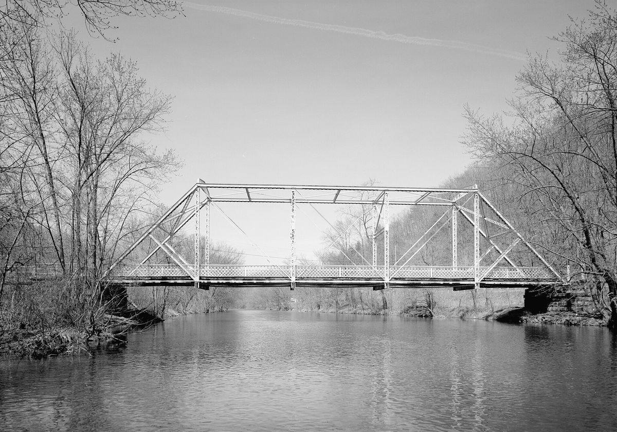
Southern (downstream) side of the Birmingham Bridge, spanning the Juniata River north of Birmingham
Southern (downstream) side of the Birmingham Bridge, spanning the Juniata River north of BirminghamJet Lowe, Historic American Engineering Record, Library of Congress. Public domain, a United States Government work. HAER PA,7-TYRO.V

The Birmingham Bridge carries Pennsylvania Route 350 over the Juniata north of Birmingham, and it does not belong to one county. Its far end is in Tyrone Township, Blair County; its near end is in Warriors Mark Township, Huntingdon County. The Historic American Engineering Record photographed it in March 1988 from the downstream side. The photographer was Jet Lowe, whose plates of the Harbison-Walker works appear elsewhere on this site.

Open this story on its own page →

1 story

Wayne township, Mifflin County

The Pennsylvania Lions Beacon Lodge Camp posts its letters to Mount Union, and nearly everyone here would tell you it is ours. It is not, quite. The camp describes itself as “a beautiful five hundred and eighty-three acre summer camp for children and adults with special needs including blindness, deafness, and many other physical and mental challenges,” set “along the Juniata River of Central Pennsylvania just two miles west of Newton Hamilton, near Mount Union.” It was established in 1948 as a summer camp for blind residents of Pennsylvania.

Its buildings stand in Wayne township, Mifflin County. What does run into this county is the road named after it: Beacon Lodge Road crosses the line and carries on west through Shirley township for most of its length. A postal address is not a county boundary, which is worth remembering every time one of these is filed.

Checked against the record. The camp's description and its 1948 founding are quoted from its own website as archived in August 2019. The county was checked twice and independently, because the postal address says Mount Union: the Census address geocoder places 114 State Route 103 in Mifflin County, Wayne township, and OpenStreetMap's node for the camp at 40.374, -77.813 geocodes to the same place. The segments of Beacon Lodge Road at 40.365, -7…

Open this story on its own page →