Huntingdon County Information Page

Borough · Huntingdon County

Shirleysburg

4 stories on file, each with its sources. 0.2 square miles of land in the ridge and valley country of central Pennsylvania.

141
Population
2020 Census, P.L. 94-171
0.16 sq mi
Land area
2020 Census gazetteer
584 ft
Elevation
Community reference point, checked against USGS
Borough
Type
GEOID 4206170408

Nearby

Straight-line miles between map centers, 2020 Census boundary file

The founding record

Shirleysburg was incorporated as a borough on April 3, 1837, with John Lutz as the first chief burgess. The completion of the East Broad Top railroad through the place in 1873 gave a new impetus to business and for a time the population showed considerable increase. Rival towns then offered better inducements for the investment of capital and for the last half a century Shirleysburg has barely held its own. In 1910 the population was 256, a slight decrease under that of 1900. Three Springs, a station on the East Broad Top railroad in the southern part of the county, was laid out in the spring of 1843 and was first called Scottsville, for General Winfield Scott. A postoffice was soon after established there under that name. Richard Ashman and William White were the first merchants. George D. Hudson built . the first hotel, in the kitchen of which was taught the first school. Dr. Robert Baird was the first physician. John W. Jordan, ed., History of the Juniata Valley and Its People (New York: Lewis Historical Publishing, 1913) · character 235,619 of the scanned text
Industries, Mills, and Manufactories of Shirleysburg., EARTHENWARE- WORKS, located on west side of Main Street, in the borough of Shirleysburg, was established in 1866 by George W. Hawker, who, with his son, D. P. Hawker, conducted the manufacture of all kinds of earthenware till April, 1871, when Mr. Hawker, Sr., died, leaving the business to his son, who is still engaged in the manufacture of pottery goods, and is also a large dealer in Ohio stoneware. Mr. Hawker's establishment is also located on the Ross tract. May 31, 1762, it was patented to Robert Coleman, Esq., subsequently purchased by John Cooper, and by him sold June 20, 1820, to Walter B. Hudson, and by Hudson to Clark, and in April, 1866, by James Clark and Mary I. Clark to G. W. and D. P. Hawker. DRAIN, TILE, AND TERRA-COTTA WORKS., Samvel Backus came to this town in 1824 or 1825, and established the pottery and earthenware business in the building next south of what is known as the " Mansion House," where he remained till 1839 or 1840, when he built the south end of what is now Phil Kabis' tile works, and removed to that place. He subsequently sold to Brewster, who continued the business for a few years, with Mr. Lutz as foreman.J. Simpson Africa, History of Huntingdon and Blair Counties, Pennsylvania (Philadelphia: Louis H. Everts, 1883) · character 2,213,854

Quoted from a work published before 1929 and therefore in the public domain in the United States. Spelling and punctuation are as printed, including nineteenth century spellings of place names. Scanned text carries optical character recognition errors; the character offset is given so the passage can be found and checked in the original.

4 stories

Stories from Shirleysburg

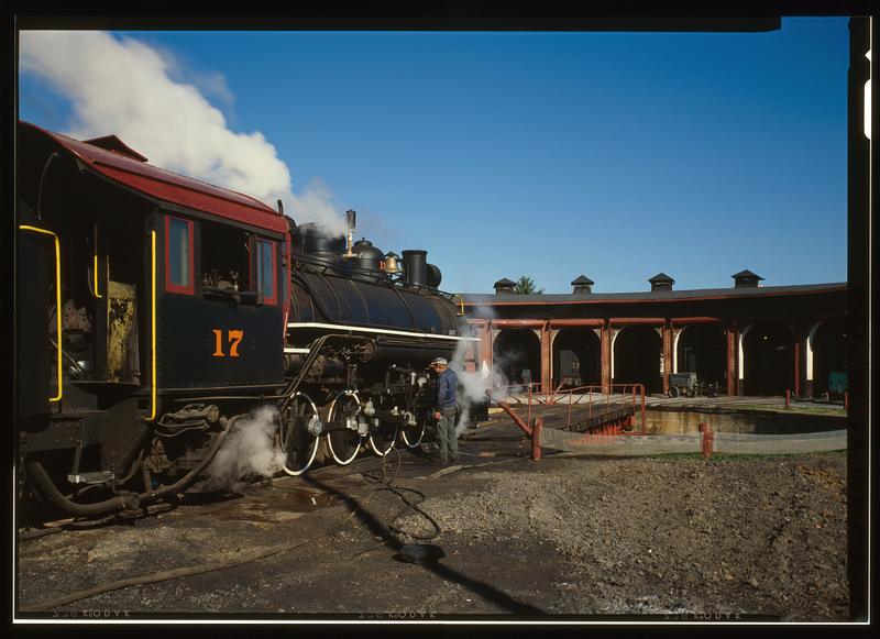
East Broad Top Railroad & Coal Company, Roundhouse, State Route 994, West of U.S. Route 522, Rockhill Furnace
East Broad Top Railroad & Coal Company, Roundhouse, State Route 994, West of U.S. Route 522, Rockhill FurnaceLibrary of Congress, Historic American Buildings Survey / Historic American Engineering Record. No known copyright restrictions. pa3371

The East Broad Top Railroad's shops stand on Meadow Street in Rockhill Furnace, a middle point on a three-foot-gauge line that ran from Mount Union to Alvan. The nomination calls the railroad one of the oldest narrow gauge lines in America, and a 1991 National Park Service inventory of the county's industrial sites records that it was designated a National Historic Landmark in 1964.

The nomination says the East Broad Top Railroad and Coal Company was established in 1871, after the Civil War interfered with an earlier plan to reach the Broad Top coal. Africa's 1883 county history says the company had been organized under an act approved April 16, 1856, that construction began on September 16, 1872, and that the road opened to Robertsdale, its southern terminus, on November 4, 1874. The 1991 inventory says the owners of Rockhill Furnace built the line to reach iron ore and coal in the region, and that it reached its greatest length in 1916 with the extension to Alvan. The road carried timber, sand, rock, general freight and passengers, but coal was its great money-maker: trains hauled it to Mount Union, where it was transferred to the Pennsylvania Railroad. In 1881, Africa records, the road carried 143,449 tons of bituminous coal.

After World War II other fuels began to supplant coal. Passenger service ended in 1953, and on April 16, 1956, the company ran its last train. The purchaser of the entire line preserved five miles of track and six steam locomotives, Mikado types built for the East Broad Top by the Baldwin works of Philadelphia, and began running part of the line as a tourist attraction in 1960. The 1991 inventory names the buyer as the Kovalchick Salvage Company of Indiana, Pennsylvania, and says the town of Orbisonia asked for the reopening to commemorate its bicentennial.

The bulk of the Rockhill yard dates from 1874, including the red brick roundhouse with berths for eight engines and the Armstrong turntable. When the form was written in 1974 the blacksmith shop, foundry and machine and car shops still housed their original machinery, and the foundry was filled with patterns used in making the rolling stock. About 1,400 feet of grade north of Shirleysburg washed out in 1972. Across Meadow Street, the Orbisonia passenger station had its waiting room converted into a gift shop and its freight room into a snack bar.

Decline in the use of coal after World War II forced the East Broad Top to cease operations in 1956. All of its track and rolling stock seemed doomed, but the purchaser of the line generously preserved five miles of the track and six of the steam engines.National Register of Historic Places nomination, East Broad Top Railroad (reference 66000666), 66000666, p. 3 · character 7,078 of the scanned text
Checked against the record. Checked against the National Register nomination text before publication; 3 claims the nomination did not support were removed or corrected.

Open this story on its own page →

Did you know? The man Purdue University is named for was born in Huntingdon County, and he had to quit school at twelve.

John Purdue was born October 31, 1802 in Germany Valley, near Shirleysburg. Purdue's own university archives describe the family plainly: his father Charles worked at a nearby iron foundry, and "the family endured extreme poverty." John was the only son among ten children. He started at a local school at eight and dropped out at twelve to work as a hired hand and help support the family.

In the early 1820s the Purdues moved to Adelphi, Ohio. He taught in a one room schoolhouse, then started selling crops and livestock for his neighbors on commission, then opened a store, then moved to Lafayette, Indiana and kept going. Bank director. Newspaper owner. Railroad organizer.

In 1869, when Indiana was looking to establish its land grant college, he put up $150,000. Among his conditions was that the college carry his name.

Classes started in the fall of 1874. The first commencement was June 16, 1875, and there was exactly one graduate, John Bradford Harper. Purdue gave the address. He died September 12, 1876 and is buried on the campus.

A boy who had to leave school at twelve in Germany Valley put his name on a university.

Checked against the record. Birthplace held up, but not from where the original got it. Neither Africa 1883 nor the 1897 Juniata Valley encyclopedia nor the 1909 Historic Huntingdon contains the name Purdue at all. Wikipedia gives Huntingdon County with NO citation on that sentence. The claim is carried by Purdue University's own Archives and Special Collections: "John Purdue was born in Germany Valley (near Shirleysburg), Pennsylvania on Octob…

Open this story on its own page →

To the right as you enter Shirleysburg from the north on Route 522 stands a two and a half story house of locally fired soft red brick, five bays wide, known locally as The Rock for its view of a rock outcropping to the northeast. Its National Register nomination, prepared in June 1983, calls it the Benjamin B. Leas House and marks three areas of significance: the architecture, the school it housed, and the ground under it.

The ground is the site of Fort Shirley. The nomination says the fort was built about 1755 or 1756 under Governor Morris and George Croghan, one of a line of stockades thrown up in 1755 stretching westward from the Susquehanna. Africa's 1883 history calls it probably Croghan's fort enlarged. When the site was visited in 1896 for the first edition of Frontier Forts of Pennsylvania, the survey found no trace of the fort except a slight depression, and residents said large stones had been carried off from a corner of one wall. In 1926 the Pennsylvania Historical Commission and the Society of Pennsylvania Women in New York put up a monument in front of the house.

Benjamin B. Leas came from a German family that settled in the Shirleysburg area in 1829. Welch's 1909 history says he and his brother William opened a store in the town in 1836, and that Benjamin was its third burgess. In April 1846 he was named one of the commissioners to take stock subscriptions for the new Pennsylvania Railroad. He bought the fort tract in 1843 and had the house finished by 1850; on 6 January 1852 he sold it to the Shirleysburg Female Seminary. The nomination says he died about 1859.

The seminary closed about 1866. From 1885 to 1893 the house was the Old Folks Home of the German Baptist Church, also called the Rock View Home. Then it was the Rockview Academy, then, from 1910, a residence; in 1983 it held the offices of the Aughwick Machine Company.

Inside are twelve rooms, four to a floor, a wide central hall with an open string stair, the original moldings and hardware, unpainted hemlock floors, and a full basement with a separate cold storage room and a spring.

The house is not a vernacular Greek Revival commonly found in the country, but a classical textbook example of an urban example transplanted into rural Pennsylvania.National Register of Historic Places nomination, Benjamin B. Leas House (reference 84003401), Benjamin B. Leas House, item 8 Significance (PDF page 12) · character 7,872 of the scanned text
Checked against the record. Checked against the National Register nomination text before publication; 4 claims the nomination did not support were removed or corrected.

Sources

  1. National Register of Historic Places nomination: Benjamin B. Leas House, reference 84003401 (1983)
  2. Charles H. Welch, History of Mount Union, Shirleysburg and Shirley Township (1909), pp. 63-64 and the Shirleysburg chapter
  3. J. Simpson Africa, History of Huntingdon and Blair Counties, Pennsylvania (1883), Fort Shirley and Pennsylvania Railroad passages

Open this story on its own page →

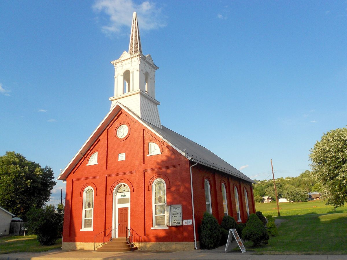
The United Methodist church, Shirleysburg, Huntingdon County, Pennsylvania
The United Methodist church, Shirleysburg, Huntingdon County, PennsylvaniaPhotograph by the Wikimedia Commons contributor Smallbones, 2016. Released under CC0, a public domain dedication. Shirleysburg PA United Methodist.jpg

The United Methodist church in Shirleysburg, photographed in July 2016 and released by its photographer into the public domain. The record names the borough but not the county, which in this case settles it anyway: there is exactly one Shirleysburg in the United States.

Checked against the record. The file carries no coordinates, so the subject rests on the name. The Census place table holds exactly one Shirleysburg in the whole country, in Pennsylvania, so the photographer's caption cannot point anywhere else.

Open this story on its own page →

Where it sits

Alexandria borough: 12 storiesBirmingham borough: 2 storiesBroad Top City borough: 2 storiesCassville borough: 2 storiesCoalmont borough: 2 storiesDudley borough: 2 storiesHuntingdon borough: 36 storiesMapleton borough: 6 storiesMarklesburg borough: 4 storiesMill Creek borough: 4 storiesMount Union borough: 137 storiesOrbisonia borough: 8 storiesPetersburg borough: 3 storiesRockhill borough: 5 storiesSaltillo borough: 5 storiesShade Gap borough: 3 storiesShirleysburg borough: 4 storiesThree Springs borough: 4 storiesBarree township: 6 storiesBrady township: 4 storiesCarbon township: 3 storiesCass township: 2 storiesClay township: 4 storiesCromwell township: 7 storiesDublin township: 5 storiesFranklin township: 10 storiesHenderson township: 6 storiesHopewell township: 5 storiesJackson township: 9 storiesJuniata township: 8 storiesLincoln township: 5 storiesLogan township: 5 storiesMiller township: 4 storiesMorris township: 2 storiesOneida township: 6 storiesPenn township: 4 storiesPorter township: 10 storiesShirley township: 10 storiesSmithfield township: 5 storiesSpringfield township: 5 storiesSpruce Creek township: 7 storiesTell township: 3 storiesTodd township: 5 storiesUnion township: 5 storiesWalker township: 9 storiesWarriors Mark township: 5 storiesWest township: 2 storiesWood township: 13 storiesHuntingdonMount UnionOrbisoniaThree SpringsPetersburgMapletonAlexandriaRockhillBroad Top CitySaltillo
10 or more4 to 91 to 3borough outline