Huntingdon County Information Page

Township · Huntingdon County

Clay

4 stories on file, each with its sources. 28.5 square miles of land in the ridge and valley country of central Pennsylvania.

868
Population
2020 Census, P.L. 94-171
28.46 sq mi
Land area
2020 Census gazetteer
Township
Type
GEOID 4206113944

Nearby

Straight-line miles between map centers, 2020 Census boundary file

The founding record

Clay township was erected on April 15, 1845, irotn Springfield, and was named for Henry Clay, of Kentucky, who was the Whig candidate for president in 1844. It is bounded on the northeast by Cass and Cromwell; on the southeast by Springfield ; on the south and southwest by Fulton county, and on the northwest by Wood and Tod townships. Benjamin Long, Henry Hubbell, George, John and William Hudson, Thomas Green, George Ashman, John Kyler, William and Miles Bunn, Thomas Hooper, Richard Bradley and some others had located in what is now Clay township before the close of the eighteenth century. The boroughs of Saltillo and Three Springs are located in this township and there are a few villages of minor importance. The East Broad Top railroad crosses the northern portion, passing through Saltillo and Three Springs. John W. Jordan, ed., History of the Juniata Valley and Its People (New York: Lewis Historical Publishing, 1913) · character 180,915 of the scanned text

Quoted from a work published before 1929 and therefore in the public domain in the United States. Spelling and punctuation are as printed, including nineteenth century spellings of place names. Scanned text carries optical character recognition errors; the character offset is given so the passage can be found and checked in the original.

4 stories

Stories from Clay

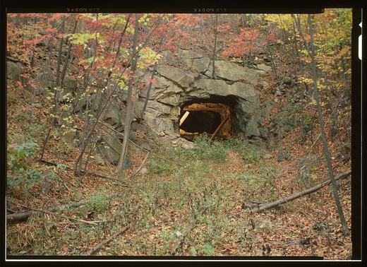
East Broad Top Railroad & Coal Company, Sideling Hill Tunnel, Rockhill Furnace
East Broad Top Railroad & Coal Company, Sideling Hill Tunnel, Rockhill FurnaceLibrary of Congress, Historic American Buildings Survey / Historic American Engineering Record. No known copyright restrictions. pa3447

The survey's cover sheet for the Sideling Hill Tunnel, HAER PA-127-F, places it in the Kimmel vicinity and holds photographs and color copies with no written history of its own. What the record says about the tunnel is spread across the parent report on the railroad, PA-127, J. Simpson Africa's 1883 county history, and the 1991 county inventory of engineering and industrial sites.

The parent report says the East Broad Top chose a three-foot gauge in June 1872, built its first leg from Mount Union to Orbisonia between September 16, 1872, and August 30, 1873, and reached the new mining town of Robertsdale on November 4, 1874. It argues that the road was built with grades and curves consistent with a broad-gauge line rather than laid on the surface of the ground, and that after several surveys the company made a serious investment in two tunnels to crest grades. The Library of Congress record dates the Sideling Hill bore to about 1874. Among the improvements the report attributes to the Seibert era, the two tunnels were relined with new timbers.

Africa's 1883 history, in its chapter on Clay Township, has the railroad passing through Three Springs and Saltillo boroughs and Clear Ridge Gap in the extreme north of the township and out through a tunnel under Sideling Hill Mountain near P. Hoffman's. The same chapter says Sideling Hill runs along the entire northwest line of the township.

The 1991 inventory gives the tunnel's construction date as 1874 and its length as 830 feet, describes it as a solid-rock bore with timber bents partly supporting unlined walls and ceiling, dates both portals to the early twentieth century, and records that after a locomotive derailment it attributes to ice build-up in January 1912, doors were put on the end of each portal to keep the wind from blowing through.

Checked against the record. Checked against the survey's written record before publication; 4 claims it did not support were removed or corrected.

Open this story on its own page →

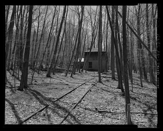
East Broad Top Railroad & Company, Water Tank at Coles Station (at Milepost 24.3)
East Broad Top Railroad & Company, Water Tank at Coles Station (at Milepost 24.3)Library of Congress, Historic American Buildings Survey / Historic American Engineering Record. No known copyright restrictions. pa4098

Half a mile east of Coles Valley Road, at milepost 24.3 on the East Broad Top main line beyond Saltillo toward Robertsdale, stands an enclosed water tank. The Historic American Engineering Record documented it as HAER PA-644, with ten photographs by A. Pierce Bounds in April 2006 and five measured drawings delineated by John R. Bowie; William A. Adams was on the field team, Henry F. Inman was historian, John Bowie Associates was the contractor, and the Friends of the East Broad Top, the Society for Industrial Archeology and the Amherst Railway Society sponsored the work. The data pages are a single cover sheet listing photographs, reduced copies of the drawings and field records, and the Library of Congress notes that unprocessed field notes exist for the structure.

The Library of Congress summary calls the tank the sole surviving example of the enclosed water stations that once stood along the EBT main line and branches, and says such tanks were typically heated with small stoves so the water for steam locomotives would not freeze in winter. The photograph index describes a wood tank bound with iron compression bands, carried on heavy timber joists and a center beam above a concrete foundation, with a one story wood frame addition on the east side that covered a stone lined, gravity fed cistern and held a pump, since removed, that lifted water up into the tank. The main line runs beside the foundation with a passing siding beyond it. In railroad parlance, the index notes, Orbisonia is railroad north and Robertsdale railroad south.

A 1991 National Park Service inventory of the county's historic engineering and industrial sites places the Coles tank house at Coles Summit, between the two railroad tunnels near the former junction of the main line and the Coles Valley branch, and says its water came from a spring on the mountainside behind the tank. The Library of Congress record and the inventory disagree on when it was built. The National Register nomination for the railroad noted that the Coles station house and tankhouse still stood, and that the Coles Valley spur was one of three the EBT ran out to strip mines, with Shade Gap and Rocky Ridge.

Checked against the record. Checked against the survey's written record before publication; 8 claims it did not support were removed or corrected.

Open this story on its own page →

From the county histories, on Clay township. The passage below is printed exactly as it appears in 1883, including the spelling of the day and the errors the scanner made. It has not been rewritten, summarised or added to.

Besides the pioneers named, others are recalled by very old present inhabitants, of Matthias Saylor, John Chilcote, George Stever, Cornelius Poston, Zachariah Lovett, and Daniel Gosnal. In Smith's Valley, beginning near the line of Clay township and going north, there were Jacob Barnett, Andrew Park, John Chaney, John Park, Jr., Philemon Reynolds, Michael Bauman, Hugh Johnson, and John Park, Sr. Reynolds was a colored man and a slave, who purchased his freedom, and afterwards bought from his former master six hundred acres of land opposite Cassville for one hundred dollars. Mr. James L. Glasgow now owns and resides on a part of this land. In Hare's Valley John Shields, James Campbell, Jacob Crotsley, Henry Freed, William Wright are remembered as very early residents. Probably not many of those named were original settlers in the township, but many were the children of pioneers, and nearly all left children, who have in their turn multiplied till their families are numerously represented here. Some of these pioneers came here from Maryland, over Indian trails that were not passable except on foot or with single animals, They brought their scanty effects on their backs, or on the backs of horses and cows, and drove the few sheep and swine that, if spared by the wolves and bears, were to be the beginnings of their future flocks.J. Simpson Africa, History of Huntingdon and Blair Counties, Pennsylvania (Philadelphia: Louis H. Everts, 1883) · character 1,559,092 of the scanned text

Open this story on its own page →

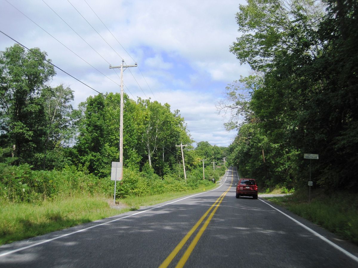
northbound Hudson Street / Oak Street entering Saltillo from Clay Township, Huntingdon County, Pennsylvania. Photo taken looking northwest between Stone Quarry Road and State Game Road.
northbound Hudson Street / Oak Street entering Saltillo from Clay Township, Huntingdon County, Pennsylvania. Photo taken looking northwest between Stone Quarry Road and State Game Road.Photograph by Mr. Matté, 2024-08-20. Licensed CC BY-SA 4.0; reused with credit, and the same licence travels with any derivative. Hudson Street wb entering Saltillo, PA, Aug. 2024.jpg

Hudson Street running into Saltillo out of Clay township, photographed in August 2024 looking north-west. Saltillo is the borough; the camera is standing in the township.

Checked against the record. Placed by the photograph's own coordinates against the Census geocoder, which returns Huntingdon / Clay.

Open this story on its own page →

Where it sits

Alexandria borough: 12 storiesBirmingham borough: 2 storiesBroad Top City borough: 2 storiesCassville borough: 2 storiesCoalmont borough: 2 storiesDudley borough: 2 storiesHuntingdon borough: 36 storiesMapleton borough: 6 storiesMarklesburg borough: 4 storiesMill Creek borough: 4 storiesMount Union borough: 137 storiesOrbisonia borough: 8 storiesPetersburg borough: 3 storiesRockhill borough: 5 storiesSaltillo borough: 5 storiesShade Gap borough: 3 storiesShirleysburg borough: 4 storiesThree Springs borough: 4 storiesBarree township: 6 storiesBrady township: 4 storiesCarbon township: 3 storiesCass township: 2 storiesClay township: 4 storiesCromwell township: 7 storiesDublin township: 5 storiesFranklin township: 10 storiesHenderson township: 6 storiesHopewell township: 5 storiesJackson township: 9 storiesJuniata township: 8 storiesLincoln township: 5 storiesLogan township: 5 storiesMiller township: 4 storiesMorris township: 2 storiesOneida township: 6 storiesPenn township: 4 storiesPorter township: 10 storiesShirley township: 10 storiesSmithfield township: 5 storiesSpringfield township: 5 storiesSpruce Creek township: 7 storiesTell township: 3 storiesTodd township: 5 storiesUnion township: 5 storiesWalker township: 9 storiesWarriors Mark township: 5 storiesWest township: 2 storiesWood township: 13 storiesHuntingdonMount UnionOrbisoniaThree SpringsPetersburgMapletonAlexandriaRockhillBroad Top CitySaltillo
10 or more4 to 91 to 3borough outline