Clay township
The East Broad Top water tank at Coles Station
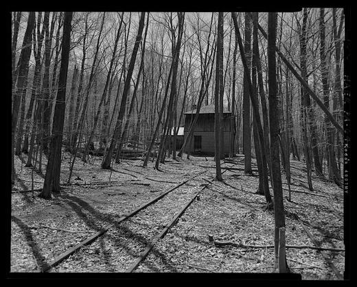
Half a mile east of Coles Valley Road, at milepost 24.3 on the East Broad Top main line beyond Saltillo toward Robertsdale, stands an enclosed water tank. The Historic American Engineering Record documented it as HAER PA-644, with ten photographs by A. Pierce Bounds in April 2006 and five measured drawings delineated by John R. Bowie; William A. Adams was on the field team, Henry F. Inman was historian, John Bowie Associates was the contractor, and the Friends of the East Broad Top, the Society for Industrial Archeology and the Amherst Railway Society sponsored the work. The data pages are a single cover sheet listing photographs, reduced copies of the drawings and field records, and the Library of Congress notes that unprocessed field notes exist for the structure.
The Library of Congress summary calls the tank the sole surviving example of the enclosed water stations that once stood along the EBT main line and branches, and says such tanks were typically heated with small stoves so the water for steam locomotives would not freeze in winter. The photograph index describes a wood tank bound with iron compression bands, carried on heavy timber joists and a center beam above a concrete foundation, with a one story wood frame addition on the east side that covered a stone lined, gravity fed cistern and held a pump, since removed, that lifted water up into the tank. The main line runs beside the foundation with a passing siding beyond it. In railroad parlance, the index notes, Orbisonia is railroad north and Robertsdale railroad south.
A 1991 National Park Service inventory of the county's historic engineering and industrial sites places the Coles tank house at Coles Summit, between the two railroad tunnels near the former junction of the main line and the Coles Valley branch, and says its water came from a spring on the mountainside behind the tank. The Library of Congress record and the inventory disagree on when it was built. The National Register nomination for the railroad noted that the Coles station house and tankhouse still stood, and that the Coles Valley spur was one of three the EBT ran out to strip mines, with Shade Gap and Rocky Ridge.
Sources
- Library of Congress, Historic American Engineering Record HAER PA-644: East Broad Top Railroad & Company, Water Tank at Coles Station, milepost 24.3, Saltillo vicinity (2006)
- HAER PA-644 data pages (cover sheet) and index to photographs, Water Tank at Coles Station, A. Pierce Bounds, photographer, April 2006
- Nancy S. Shedd, Huntingdon County, Pennsylvania: An Inventory of Historic Engineering and Industrial Sites (Washington: National Park Service, HABS/HAER, 1991), East Broad Top Railroad, Coles Tank House; cited, not quoted, as the work is in copyright
- National Register of Historic Places nomination file: East Broad Top Railroad, reference 66000666 (form with additions as of 1990)
Checked 2026-09-05 · Library of Congress survey record, read in full
← All stories from Clay township
Have something to add to this story, or a photograph of it? Send it here →
Photographs from Clay township
More from Clay township
The survey's cover sheet for the Sideling Hill Tunnel, HAER PA-127-F, places it in the Kimmel vicinity and holds…
Clay township, Clay: the first settlersFrom the county histories, on Clay township. The passage below is printed exactly as it appears in 1883, including the…
Clay township, The Road Into SaltilloHudson Street running into Saltillo out of Clay township, photographed in August 2024 looking north-west. Saltillo is…
Also about railroads
Where the East Broad Top Railroad crosses Aughwick Creek at Aughwick Mills, a concrete bridge carried the narrow gauge…
elsewhere in the county, The East Broad Top station at SaltilloThe Saltillo station stands between the East Broad Top main line at milepost 18.8 and South Main Street, Pennsylvania…