Huntingdon County Information Page

Township · Huntingdon County

Spruce Creek

7 stories on file, each with its sources. 8.5 square miles of land in the ridge and valley country of central Pennsylvania.

199
Population
2020 Census, P.L. 94-171
8.46 sq mi
Land area
2020 Census gazetteer
0.08 sq mi
Water
2020 Census gazetteer
Township
Type
GEOID 4206173488

Nearby

Straight-line miles between map centers, 2020 Census boundary file

The founding record

SPRUCE CREEK, a station on the railway a mile above the tunnel, is situated on both "sides of the Little Juniata, and consequently is in two townships. That part lying in Franklin contains the manufacturing interests on Spruce Creek, while the Morris part of the village has the hotel and stores of the place. In the former is a fine Presbyterian Church, while the latter contains a Methodist house of worship. The two parts are connected by a bridge, which is the third across the stream at this point, the second having been destroyed by the great flood of Oct. 8, 1847. The first bridge was erected in 1819, and the second a year before its destruction, The general interests of the two-parts are so much interblended that they are here considered as belonging to the village of Spruce Creek, in Morris. The population in 1880 was two hundred and eighteen. The first settlers in this locality were two brothers by the name of Bebault, who built a small tub-mill near the mouth of Spruce Creek, about 1775. Later the property was owned by Abraham Sells, who had in connection with his mills a public-house. Ata yet later period Jacob: Beigle purchased the mills and some six hundred acres of land from Gen. Heister, of Reading, Pa., and divided his property among his five sons, who retained ownership until 1827, when John 8. Isett secured the property, and it is yet owned by his family. J. Simpson Africa, History of Huntingdon and Blair Counties, Pennsylvania (Philadelphia: Louis H. Everts, 1883) · character 2,112,081 of the scanned text
Spruce Creek township, the youngest, but one in the county, was erected in September, 1895, from the townships of Morris, Franklin and Porter. It takes its name from the stream which empties into the Juniata river opposite the village of Spruce Creek.John W. Jordan, ed., History of the Juniata Valley and Its People (New York: Lewis Historical Publishing, 1913) · character 202,264

Quoted from a work published before 1929 and therefore in the public domain in the United States. Spelling and punctuation are as printed, including nineteenth century spellings of place names. Scanned text carries optical character recognition errors; the character offset is given so the passage can be found and checked in the original.

7 stories

Stories from Spruce Creek

Between the village of Spruce Creek and the borough of Birmingham the Pennsylvania Railroad's main line follows the Little Juniata River, which the nomination calls the path of least resistance through the mountains. From the first survey, the ground left the engineers little choice about where the track could run. The result is a 5.15-mile stretch, between Conrail mile markers 213.73 and 218.88, on which the railroad crosses the river ten times on stone arch bridges and passes through a spur of Tussey Mountain in two parallel tunnels. The nomination, prepared at the Pennsylvania Historical and Museum Commission in November 1989 and drawing on Nancy Shedd's 1988 report for the Historic American Engineering Record, calls it the most heavily built section of the line in bridges and tunnels per mile.

The first tunnel came with the original single track. It is 1,151 feet long, brick arched and 32 feet wide, and the nomination dates it to 1850. Lytle's 1876 county history says the opening through the mountain was made in June 1849, eleven months after the first pick was struck into it, and that premature blasts caused several serious accidents there, one of which killed a man. The 1991 county engineering inventory adds that the hand digging and blasting were carried out largely by Irish immigrants. When the railroad four-tracked the main line in 1900 it bored a second tunnel, 1,075 feet long, through the same mountain. The western openings of the two were joined in a double portal, while the eastern portal of the 1850 tunnel keeps its original appearance.

The bridges are not the originals. The nomination says the first bridges on this right of way were iron, and that the reason for replacing them in stone is not certain; the form's guess is that the iron was deteriorating as locomotives grew heavier. The bridge dates in the nomination's table run from 1886 to 1902. Those built before 1892 had to be widened when the extra tracks came. The nomination puts the last major reinforcement with steel and concrete at 1953, though its own table lists major repairs on six of the bridges between 1958 and 1963. Alterations made before 1940 count toward the district's integrity rather than against it.

The nomination reached the National Park Service on February 7, 1990, and the district was judged significant at the statewide level for engineering and transportation, with a period of significance from 1850 to 1939. The longest of the ten bridges, at mile 215.06, has five arches and runs 298 feet.

The railroad's route along the Little Juniata must have tormented the original engineers and contractors and those who followed during the four tracking.National Register of Historic Places nomination, Pennsylvania Railroad District (reference 90000393), Pennsylvania Railroad District, section 8 page 2 (PDF page 6) · character 9,188 of the scanned text
Checked against the record. Checked against the National Register nomination text before publication; 6 claims the nomination did not support were removed or corrected.

Sources

  1. National Register of Historic Places nomination: Pennsylvania Railroad District, reference 90000393 (1989)
  2. Lytle, History of Huntingdon County (1876), p. 149
  3. Huntingdon County Historic Engineering and Industrial Sites Inventory (1991), Pennsylvania Railroad: Spruce Creek Tunnel, p. 79
Open this story on its own page →

Eden Hill Farm, in rural Spruce Creek Township in the north of Huntingdon County, was placed on the National Register as the Hugh D. and Martha S. Seeds Farm. Its 96 acres hold a coursed limestone farmhouse the nomination dates to about 1830, a Pennsylvania bank barn of about 1880, and the lanes, fence rows and field pattern of a nineteenth-century farm.

The name goes back to Robert E. Stewart, an immigrant from County Down, Ireland. J. Simpson Africa's 1883 county history tells how he and his wife Elizabeth looked over the forest they had bought and thought it a second garden of Eden, and how they slept under a large oak tree until he built a cabin of poles. The nomination says his will divided the farm among his three children and that his daughter Martha, who had married Hugh D. Seeds, also an Irish immigrant, in the 1820s, received 110 acres. It says Hugh and Martha built the house shortly after acquiring the property in 1830. Africa records that Hugh Seeds improved a farm in that neighborhood and that his son John owned it by 1883. John Seeds sold Eden Hill to Edward B. and Elizabeth Isett in 1888, and the Isetts held it until 1951.

The house is two and a half stories, five bays wide, with a full Georgian plan, interior end chimneys and a raised basement across the front. It keeps its original floor plan, floors, plaster, woodwork, doors, windows and hardware. A basement kitchen with its cooking fireplace and crane sits beneath the first-floor kitchen and dining room; the nomination says it was most likely the place for canning, rendering and washing. The front door carries a signed Carpenter lock with the seal of Pennsylvania, and a plaster medallion four feet across is set in the first-floor passage. The barn, about 40 by 100 feet, is a four-bay bank barn with a cantilevered forebay, its frame laid out by the square rule on mill-cut timber. Its only alterations are three enlarged ground-floor openings for machinery and the loss of the roof ventilators.

The farm was listed under Criteria A and C, for agriculture and architecture, for the period 1830 to 1948, and it was still a working farm when the nomination was written: three of its five fields were in crops, one fallow and one in pasture, with a tree-lined lane running north from the barn.

The woodwork of the dwelling exhibits an articulated sense of hierarchy within the building, with the most elaborate woodwork found in the room most distant from the kitchen, the southeast parlor. The less formal and public rooms, such as the second-floor chambers, have simpler woodwork.National Register of Historic Places nomination, Hugh D. and Martha South Seeds Farm (reference 99000328), section 7 page 2 (PDF page 4) · character 7,717 of the scanned text
Checked against the record. Checked against the National Register nomination text before publication; 4 claims the nomination did not support were removed or corrected.

Open this story on its own page →

Did you know? The world's largest operating steam locomotive crossed Huntingdon County this summer.

Union Pacific's Big Boy 4014 came through on Wednesday, July 8, on its east coast tour celebrating America250. The Huntingdon Daily News reported that it passed through Mount Union, Mapleton, Mill Creek and Huntingdon, where it stopped for about 10 minutes. From there it went on through Spruce Creek and then on to Tyrone. Hundreds of spectators lined the route.

Checked and confirmed. CONFIRMED 2026-10-03 against the sources listed: every factual sentence was tied to a verbatim passage and a script confirmed each passage is in its source. Where sources disagreed on a number, the number was left out. Information shared with us by readers is given as theirs, not as fact: Lynn Klingel.

Open this story on its own page →

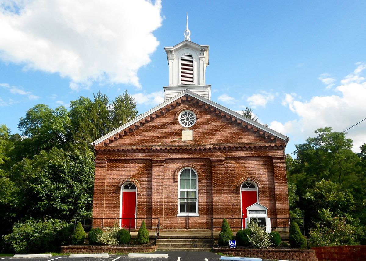
Lower Spruce Creek Presbyterian Church, Spruce Creek, Huntingdon County, Pennsylvania
Lower Spruce Creek Presbyterian Church, Spruce Creek, Huntingdon County, PennsylvaniaSmallbones, via Wikimedia Commons. Creative Commons Zero (CC0), a public domain dedication. CC0

Spruce Creek township's first photograph on this site. The valley is best known outside the county for its trout water, which is why a president fished it, but the church came first and is what the township was organised around.

Open this story on its own page →

From the county histories, on Spruce Creek township. The passage below is printed exactly as it appears in 1876, including the spelling of the day and the errors the scanner made. It has not been rewritten, summarised or added to.

The latter division is a spur usually known as the Short mountain, about two miles in length, extending from one river to the other. The Pennsylvania railroad passes through a tunnel in the northern end of it, half a mile below the village of Spruce Creek. The greater part of the township consists of an elevated plateau, to which has been given the name of Canoe valley, from the mountain enclosing it on the west. It has a fertile limestone soil, which yields generously to the hand of cultivation. One locality in this township, Water Street, is mentioned by John Harris in his "account of the road to Logstown," in 1754. The old Indian war-patb passed through it, and Conrad Weiser was there in 1748. It derived its name from the fact that a stream of water literally flowed through the street. During the Revolutionary war, General Roberdeau had a landing there, from whence lead ore, mined in Sinking valley, was shipped east to be melted, and where stores were received for the miners and troops at Fort Roberdeau. The most prosperous days of Water Street were while the Pennsylvania canal was in successful tide of operation. But since it has been closed and abandoned, the place has lost all importance, trade and travel having been diverted to points on the line of public improvements, a few miles northward. The business once attracted to Water Street by the canal is now drawn to Spruce Creek by the Pennsylvania railroad.Milton Scott Lytle, History of Huntingdon County (Lancaster: William H. Roy, 1876) · character 550,752 of the scanned text

Open this story on its own page →

From the county histories, on Spruce Creek township. The passage below is printed exactly as it appears in 1876, including the spelling of the day and the errors the scanner made. It has not been rewritten, summarised or added to.

Directly opposite was the mouth of a creek coming down from among the mountains and passing a short distance above its confluence with the river, through a narrow defile, which widens into a small valley, forming a level space of limited extent. The village of Spruce Creek proper, or Graysport, as it was originally named, stands on the south side of the Little Juniata, but intimately connected with the other side of the river that the two form but one community, I shall treat them accordingly. James Gray became the owner of the land on which the village is situated under a purchase from John Cannon, but the interest of the latter being afterwards sol'd at Sheriff's sale, was bought by John McCahan, of Huntingdon. A controversy arose between Gray and McCahan concerning the title, which was compromised, and a deed executed by the latter to the former on the 15th day of April, 1820. Gray had a tannery, not on the part upon which he subsequently laid out the village, but at the upper or Gray's fording, on land now owned by Michael Low. Until recently, a great willow tree stood there, which had been planted by Matthew Gray when a boy, the stump of which remains.Milton Scott Lytle, History of Huntingdon County (Lancaster: William H. Roy, 1876) · character 554,127 of the scanned text

Open this story on its own page →

Did you know? More than 200 immigrant Italian and southern Black laborers dug the second railroad tunnel at Spruce Creek, and they lived in a collection of shanties known as Tunneltown.

The Pennsylvania Railroad built the tunnel in 1899 and 1900, boring through a spur of Tussey Mountain north of the original 1850 tunnel and nearly parallel to it. It was part of the work that gave the main line four tracks. The new tunnel is 1,075 feet long, lined with brick, and 32 feet wide, built for two tracks. At the western end the openings of the two tunnels are joined in a double portal.

The shanties of Tunneltown stood west of the site.

Checked and confirmed. CONFIRMED 2026-10-03 against the sources listed: every factual sentence was tied to a verbatim passage and a script confirmed each passage is in its source. Where sources disagreed on a number, the number was left out.

Open this story on its own page →

Where it sits

Alexandria borough: 12 storiesBirmingham borough: 2 storiesBroad Top City borough: 2 storiesCassville borough: 2 storiesCoalmont borough: 2 storiesDudley borough: 2 storiesHuntingdon borough: 36 storiesMapleton borough: 6 storiesMarklesburg borough: 4 storiesMill Creek borough: 4 storiesMount Union borough: 137 storiesOrbisonia borough: 8 storiesPetersburg borough: 3 storiesRockhill borough: 5 storiesSaltillo borough: 5 storiesShade Gap borough: 3 storiesShirleysburg borough: 4 storiesThree Springs borough: 4 storiesBarree township: 6 storiesBrady township: 4 storiesCarbon township: 3 storiesCass township: 2 storiesClay township: 4 storiesCromwell township: 7 storiesDublin township: 5 storiesFranklin township: 10 storiesHenderson township: 6 storiesHopewell township: 5 storiesJackson township: 9 storiesJuniata township: 8 storiesLincoln township: 5 storiesLogan township: 5 storiesMiller township: 4 storiesMorris township: 2 storiesOneida township: 6 storiesPenn township: 4 storiesPorter township: 10 storiesShirley township: 10 storiesSmithfield township: 5 storiesSpringfield township: 5 storiesSpruce Creek township: 7 storiesTell township: 3 storiesTodd township: 5 storiesUnion township: 5 storiesWalker township: 9 storiesWarriors Mark township: 5 storiesWest township: 2 storiesWood township: 13 storiesHuntingdonMount UnionOrbisoniaThree SpringsPetersburgMapletonAlexandriaRockhillBroad Top CitySaltillo
10 or more4 to 91 to 3borough outline