Huntingdon County Information Page

Township · Huntingdon County

Porter

10 stories on file, each with its sources. 35.2 square miles of land in the ridge and valley country of central Pennsylvania.

1,904
Population
2020 Census, P.L. 94-171
35.25 sq mi
Land area
2020 Census gazetteer
0.22 sq mi
Water
2020 Census gazetteer
Township
Type
GEOID 4206162160

Nearby

Straight-line miles between map centers, 2020 Census boundary file

The founding record

Porter township was erected in November, 1814, when the old township of Huntingdon was divided into two new ones , Porter and Henderson. It was named for General Andrew Porter, an officer in the American army during the Revolutionary war and afterward surveyor-general. The original area of this township has been much reduced by the formation of Walker township in 1827 and Smithfield in 1886. A portion of it was also taken to form the township of Spruce Creek in 1895. The old Indian path passed through this section of the county and Porter township was one of the first to be settled, the first land warrants being dated in 1755, the year following the purchase of the land from the Indians. The first settlements were made in the vicinity of Alexandria. John W. Jordan, ed., History of the Juniata Valley and Its People (New York: Lewis Historical Publishing, 1913) · character 198,810 of the scanned text

Quoted from a work published before 1929 and therefore in the public domain in the United States. Spelling and punctuation are as printed, including nineteenth century spellings of place names. Scanned text carries optical character recognition errors; the character offset is given so the passage can be found and checked in the original.

10 stories

Stories from Porter

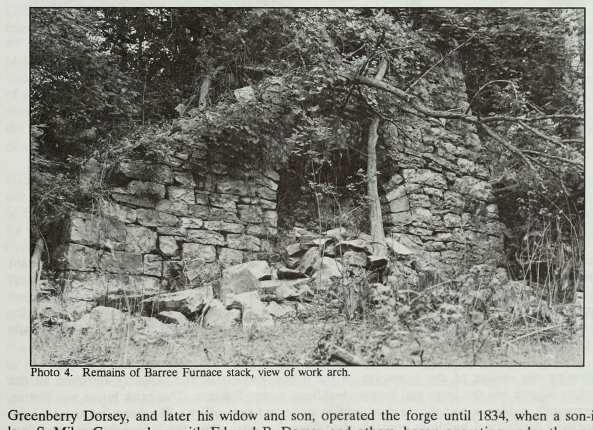
The remains of the Barree Furnace stack, the work arch at the centre, photographed for the National Park Service survey of the county's industrial sites in 1991.
The remains of the Barree Furnace stack, the work arch at the centre, photographed for the National Park Service survey of the county's industrial sites in 1991.Nancy S. Shedd et al., Huntingdon County, Pennsylvania: An Inventory of Historic Engineering and Industrial Sites (Historic American Buildings Survey / Historic American Engineering Record, National Park Service, 1991), photograph 4 stg06

On the north bank of the Little Juniata, opposite the village of Barree and two miles north of Alexandria, a field holds the remains of an early ironworks. In the 1790s Edward Bartholomew bought land there and, with his son in law Greenberry Dorsey, put up Barree Forge. The nomination puts the purchase in 1795; J. Simpson Africa's 1883 county history says the spring of 1794 and names the seller as Lazarus Brown McLane. The forge took its name from old Barree Township, which held it until West Township was formed in 1798, and the nomination calls it the earliest ironworks in northern Huntingdon County. Africa writes that its pig metal came from Centre Furnace for many years.

Dorsey, then his widow and son, ran the forge until 1834, when his son in law S. Miles Green, with Edward B. Dorsey and others, took it on as Dorsey, Green & Co. The same group ran Union and Mill Creek furnaces. Green was ironmaster into the 1860s, and his sons, Joseph and G. Dorsey, were each briefly designated ironmaster. The old forge gave way to larger ones more than once, and in 1864, with the Civil War raising demand, a furnace was added. In the 1870s the Dorsey heirs sold to A. L. Mumper of Bethlehem, who died in 1875; his widow and young son John carried on into the 1880s. The nomination says the works was liberally capitalized and in one family's hands for almost its whole life, and calls it one of the area's most productive iron businesses.

After the ironworks closed in the 1880s the owners cleared away the workers' houses and the forge and furnace buildings. The nomination counts three buildings spared: a brick house of the 1830s that had been the ironmaster's residence and later a store and post office, a second mansion, and the large barn. Africa records a Barree Forge post office from 1853, with the proprietors usually serving as postmasters. The furnace stack of 1864, thirty feet square in coursed limestone, stood six to fifteen feet high in 1989, its casting and tuyere arches intact. The property had by then been the summer camp of the Central Pennsylvania Conference of the United Methodist Church for twenty years, and in the field, piles of slag, depressions, and the stone and concrete remains of a dam on McClain's Run marked where the forge had stood.

The forge was improved and expanded repeatedly, and a furnace was added to the operation in 1864, during the brief ripple of excitement which Civil War demands caused at area ironworks.National Register of Historic Places nomination, Barree Forge and Furnace (reference 90000405), section 8, continuation page 2 (PDF page 6) · character 9,558 of the scanned text
Checked against the record. Checked against the National Register nomination text before publication; 6 claims the nomination did not support were removed or corrected.

Open this story on its own page →

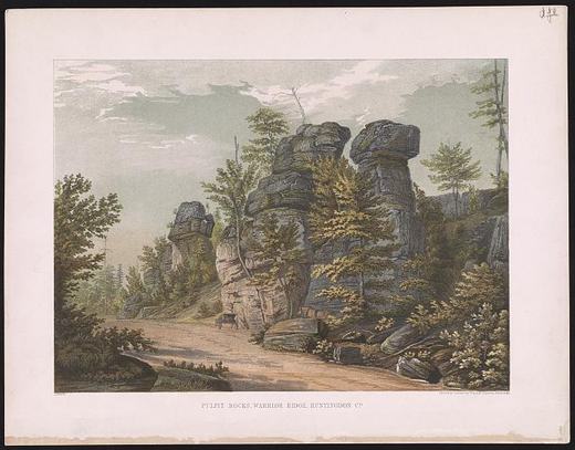
Pulpit Rocks, Warrior Ridge, Huntingdon Co
Pulpit Rocks, Warrior Ridge, Huntingdon CoLibrary of Congress, Prints and Photographs Division. No known restrictions on publication. 2015650273

On the crest of Warrior Ridge, about a mile and a half northwest of Huntingdon along the old Huntingdon and Hollidaysburg Turnpike, weathered sandstone stands in columns named for a fancied resemblance to pulpits. Africa's 1883 county history says the elements wore the stone into grotesque shapes that attracted considerable attention as natural curiosities. I. C. White's 1885 county geology called them rock cities, isolated piles of rock fifty feet high with passageways one to ten feet wide between them.

The rock is the Oriskany sandstone, laid down in an inland sea roughly 390 million years ago. Weathering along the joints isolates the columns and leaves an almost pure sand soil never suited to farming. The site has never been mined.

It was nominated as a National Historic Landmark in 1992 for what happened here in 1836, the year Governor Joseph Ritner signed the bill creating the First Geological Survey of Pennsylvania. Henry D. Rogers, a 26-year-old professor at the University of Pennsylvania, led it, with assistants James C. Booth, 24, and John F. Frazer, 26. Frazer worked down from the Broad Top coal measures through Terrace Mountain and Tussey Mountain into Morrison's Cove and found that the sandstones holding up those two mountains were not the same rock, as geologists had thought, but were separated by thousands of feet of other layers. Rogers did not believe him at first. When Booth reported the same sequence from the Potomac in western Maryland and Rogers checked Frazer's sites himself, the three agreed at a Sunday meeting in Huntingdon that summer. The nomination says that agreement set the framework for later geologic work throughout the Appalachians, and quotes J. Peter Lesley, state geologist of the second survey, writing in 1876 that American structural geology was born in 1836.

George Lehman painted the rocks and the road in an 1840 watercolor that became the frontispiece of Rogers's final report, published in 1858, and the nomination says the road, rocks and vegetation look much as they did then. Most of the site belongs to Juniata College, given by the Africa family under a deed requiring preservation in perpetuity; the rest is owned by the John V. Eisenberg heirs and used by a local game and hunt club. On September 26, 1986, the Field Conference of Pennsylvania Geologists and the college dedicated a plaque on the principal pulpit nearest the road.

Upon the upper plateau of the Warrior Ridge the traveller will see piles of blocks, called the Pulpit Rocks, remnants of the once more widely outspread upper strata, reared in rude columns one upon another.National Register of Historic Places nomination, Pulpit Rocks (reference 93001614), Henry D. Rogers, final report of the First Geological Survey (1858), as quoted in the National Historic Landmark nomination for Pulpit Rocks, page 3 · character 4,305 of the scanned text
Checked and confirmed. Every date, name and number was matched to the National Register nomination text before publication.

Sources

  1. National Register of Historic Places nomination: Pulpit Rocks, reference 93001614 (1992)
  2. Africa, History of Huntingdon and Blair Counties (1883), Porter Township
  3. White, The Geology of Huntingdon County (1885), p. 215

Open this story on its own page →

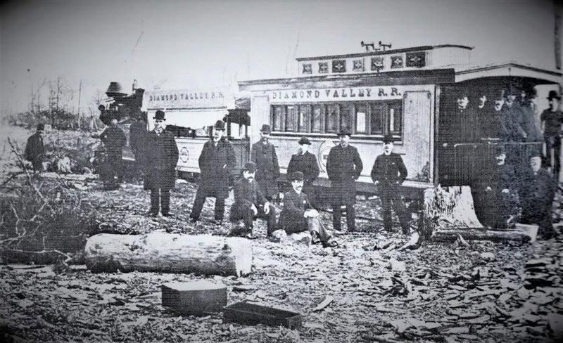
Diamond Valley Railroad cars and a group of men
Diamond Valley Railroad cars and a group of menShared by Myer Souders

Did you know? Huntingdon County once had a railroad called the Diamond Valley Railroad, built by a lumberman, and for a time its bridge was how people on foot got across the Juniata at Barree.

David Gring, who sold many millions of feet of lumber, built it to develop a tract of 20,000 acres in Huntingdon County, his obituary says: some fifteen miles of railroad, bridging the Juniata and joining the main line of the Pennsylvania Railroad at Barree. In June 1890 a Bellefonte paper reported a man killed while helping to shift cars on the Diamond Valley railroad. And after the June flood of 1889 swept away the county bridge at Barree, people on foot were obliged to use the Diamond Valley railroad bridge, the Huntingdon Globe reported in 1892.

Myer Souders shared this photograph of the line's cars, lettered DIAMOND VALLEY R.R., with a group of men lined up beside them.

Checked and confirmed. CONFIRMED 2026-10-09 against the sources listed: every factual sentence was tied to a verbatim passage and a script confirmed each passage is in its source. Information shared with us by readers is given as theirs, not as fact: Myer Souders.

Open this story on its own page →

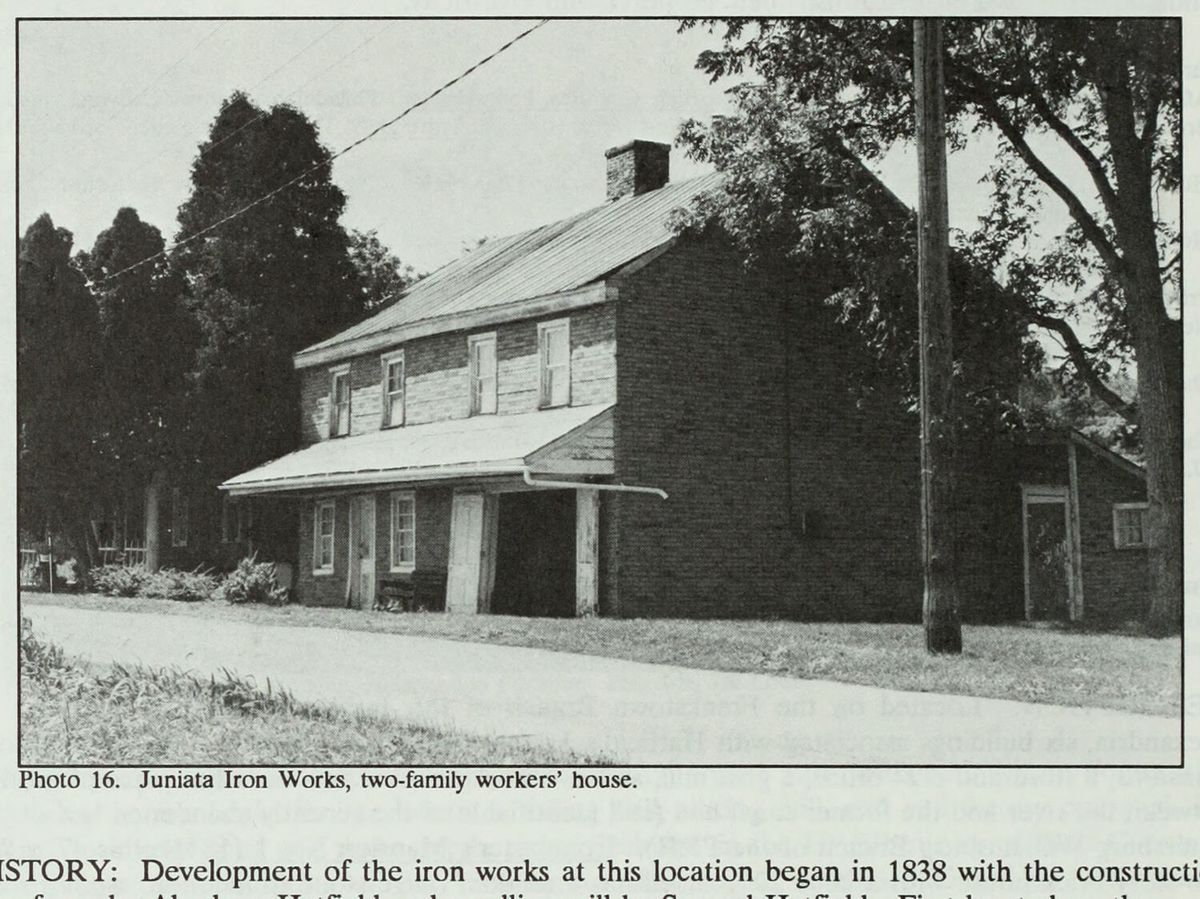
The two-family workers’ house at the Juniata Iron Works.
The two-family workers’ house at the Juniata Iron Works.Nancy S. Shedd et al., Huntingdon County, Pennsylvania: An Inventory of Historic Engineering and Industrial Sites (Historic American Buildings Survey / Historic American Engineering Record, National Park Service, 1991), photograph 16 shd016

East of Alexandria, between the Frankstown Branch of the Juniata and the old canal bed, six buildings remain of the Juniata Iron Works. The National Register nomination, prepared in August 1989, lists them: two ironmaster's mansions, a store and post office, a grist mill, and two workers' houses.

The works began in 1838, when Abraham Hatfield built a forge and Samuel Hatfield a rolling mill on a tract called Berwick. The nomination puts both on the south side of the river at first; Africa's 1883 county history places the forge there and the rolling mill on the opposite bank, a quarter mile below the dam. Africa adds that Samuel Hatfield, a native of Chester County, had bought three hundred acres on the river bend below Alexandria in 1836 and dammed the stream the next year for a twelve foot head. Samuel Hatfield added a puddling furnace in 1845 to make blooms. In the late 1840s the Hatfields moved the south bank machinery across the river; the nomination suggests damage from the Pumpkin Flood of October 1847 may have prompted the move. Figures for 1850 show 60 men making 1,100 tons of blooms and 150 tons of bar and sheet iron, worth $57,500.

The 1850s brought grist, saw and plaster mills; by 1860 there were 12 men in the rolling mill and 78 at the forges and puddling furnace. The rolling mill burned in 1869 and was not rebuilt. The business ended with the closing of the Pennsylvania Canal in 1875, which the Hatfields had depended on to ship their iron. Porter Township tax assessments for 1876 show the works vacated. Africa wrote in 1883 that the works had been dismantled, that the houses which once held thirty seven families had dwindled to a few, and that a good grist mill was the one thing still running.

That grist mill kept going as Hellyer's Mill, and early in the twentieth century made power for the Wilson Electric Company of Alexandria; feed milling there lasted into the late 1950s.

The first ironmaster's mansion went up in 1841 on the north bank, its five bay front facing south toward the river. Probably in the 1870s, the nomination says, the house was turned to face north and given brackets under the eaves, an arched porch and a bay window. The second mansion, dated to 1867, overlooks the later works. Both are brick.

The setting occupied by the Juniata Iron Works buildings, on a flat piece of ground between the river and the former canal bed (still identifiable as the recently abandoned bed of the Petersburg-Williamsburg Branch of the PRR), makes their dependence on a source of power and of transportation very clear.National Register of Historic Places nomination, Juniata Iron Works (reference 90000404), Juniata Iron Works, section 8 continuation (PDF page 7) · character 11,293 of the scanned text
Checked against the record. Checked against the National Register nomination text before publication; 4 claims the nomination did not support were removed or corrected.

Sources

  1. National Register of Historic Places nomination: Juniata Iron Works, reference 90000404 (1989)
  2. J. Simpson Africa, History of Huntingdon and Blair Counties, Pennsylvania (1883), pp. 425-426
  3. Huntingdon County, Pennsylvania: An Inventory of Historic Engineering and Industrial Sites (HAER, 1991), Juniata Iron Works entry

Open this story on its own page →

Did you know? Mount Union was not the only town in this county making silica brick. Alexandria had a plant too.

Federal Refractories built a plant west of Alexandria in 1904, at the base of Tussey Mountain. An incline connected it with its quarry on the mountaintop, and the new Petersburg branch of the Pennsylvania Railroad passed within yards of the works, bringing coal for the machinery and kilns and hauling the finished brick to distant markets. A county history printed in 1937 names the large silica brick plants at Mount Union and Alexandria together.

By the end of the 1950s the Alexandria plant had shut down. Maryland Refractories bought it in 1959 to make grog from reclaimed brick, moved to Ohio in the early 1980s, and the plant was razed in 1988.

Checked and confirmed. CONFIRMED 2026-10-03 against the sources listed: every factual sentence was tied to a verbatim passage and a script confirmed each passage is in its source. Where sources disagreed on a number, the number was left out. Information shared with us by readers is given as theirs, not as fact: Myer Souders.

Open this story on its own page →

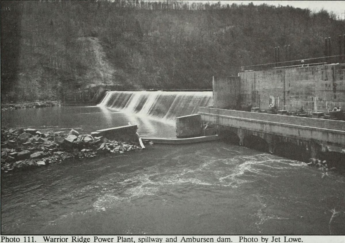
Water going over the spillway at Warrior Ridge, with the Ambursen dam and the power plant to the right.
Water going over the spillway at Warrior Ridge, with the Ambursen dam and the power plant to the right.Nancy S. Shedd et al., Huntingdon County, Pennsylvania: An Inventory of Historic Engineering and Industrial Sites (Historic American Buildings Survey / Historic American Engineering Record, National Park Service, 1991), photograph 111, photograph by Jet Lowe shd111

Two miles south of Petersburg, where the Frankstown Branch of the Juniata cuts a gap through Warrior Ridge, a hollow concrete dam and a power plant were built in 1905 to 07 for the Juniata Hydro-Electric Company of Philadelphia. William H. Cushman, the company's chief engineer, designed the power house and hydraulic installation. A.G. Wood planned the auxiliary coal fired steam plant, the General Electric Company designed the electrical installation, and the Ambursen Hydraulic Construction Company designed and built the dam.

The main dam is 400 feet long and 27 feet high, reinforced concrete with one foot plank flash boards, running from the power plant on the north bank to the steep slope of the ridge on the south. An auxiliary dam 110 feet long and of the same design was added in 1907, north of the plant. Ambursen had patented the buttressed hollow core dam in 1904. The nomination says Warrior Ridge was one of the earliest covered versions of that design and drew widespread attention in the engineering press. The Engineering Record ran it on December 22, 1906, and Huntingdon's Semi-Weekly News reprinted the article on February 14, 1907 under the headline "Description of the Wonderful Hydro-Electric Plant, Warrior Ridge."

The plant had a capacity of 8,000 horsepower and contracted to supply Huntingdon and its surrounding communities, Altoona and Tyrone. The company built four houses in 1907, three bungalows of 25 by 30 feet and one double house, and, the nomination says, a small frame church in the 1910s. The 1910 census counted a superintendent, an operator and two stationary firemen living there.

Pennsylvania Hydro Electric took the complex in 1911 when Juniata Hydro could not satisfy its mortgages. Penelec bought it in 1927 and ran both hydro and steam until 1952, when the steam plant closed and the houses were sold to individual owners. The Agnes flood of 1972 wrecked turbines and other equipment, and a major portion of the plant was demolished in 1978. A 1991 National Park Service inventory of the county's engineering sites says American Hydro Power bought the plant from Penelec in 1984 and brought it back on line in 1985 as a 2.8 megawatt station, with one original turbine, a 1906 S. Morgan Smith unit repaired after Agnes, still in its chamber. In 1989 the former church, 15 by 18 feet, was being used to treat water for the company houses.

Although electricity was produced on a small scale at isolated and scattered locations throughout the county, this operation represents the first and only large scale production in the county at this time. This permitted large scale change in industrial production to the areas served by the power company.National Register of Historic Places nomination, Warrior Ridge Dam and Hydroelectric Plant (reference 90000701), 90000701, section 8, p7 · character 11,219 of the scanned text
Checked against the record. Checked against the National Register nomination text before publication; 5 claims the nomination did not support were removed or corrected.

Open this story on its own page →

Did you know? As early as 1774, Jacob and Josiah Minor ran a grist mill on the Little Juniata, where the Barree Iron Works later stood, so simple that it was long preserved as a relic.

The pioneer millwright Edward Bell described it. The mill house was about twelve feet high and about fourteen square, made of small logs, with neither floor nor loft. The tub wheel was some three feet across. In place of a hoop around the millstones they used a hollow buttonwood tree, cut off to fit. The meal trough was made from part of a gum tree, and the bolting chest had a pair of deer skins spliced together for a door. There was not an ounce of iron about the chest or bolting reel.

In the last years of the Revolution the mill was run by lessees. One of them, Peter Crum, was killed by Indians on his way home to what is now Logan Township.

Checked and confirmed. CONFIRMED 2026-10-03 against the sources listed: every factual sentence was tied to a verbatim passage and a script confirmed each passage is in its source. Where sources disagreed on a number, the number was left out.

Open this story on its own page →

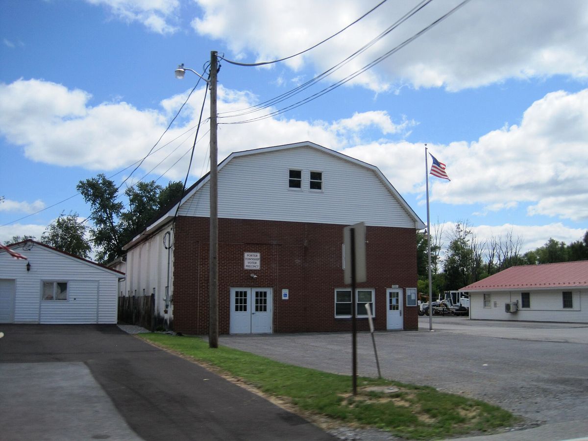
the Porter Township, Huntingdon County, Pennsylvania municipal building. Photo taken from Pennsylvania Route 305 (Bridge Street) looking east-southeast.
the Porter Township, Huntingdon County, Pennsylvania municipal building. Photo taken from Pennsylvania Route 305 (Bridge Street) looking east-southeast.Photograph by Mr. Matté, 2024-08-20. Licensed CC BY-SA 4.0; reused with credit, and the same licence travels with any derivative. Porter Twp., Huntingdon Co., PA municipal building, Aug. 2024.jpg

The Porter township municipal building, photographed in August 2024 from Bridge Street, which is also Pennsylvania Route 305.

Checked against the record. Placed by the photograph's own coordinates against the Census geocoder, which returns Huntingdon / Porter.

Open this story on its own page →

From the county histories, on Porter township. The passage below is printed exactly as it appears in 1883, including the spelling of the day and the errors the scanner made. It has not been rewritten, summarised or added to.

Prior to this arrangement the church was connected with other congregations in forming a parish. The Keller Reformed Church of Canoe Valley. , The Reformed congregation was organized at an earlier day, and embraced members living in Sinking Valley, Canoe Valley, and Porter township. The Rev. John Deitrick Aurandt came among the adherents of that faith in 1798, and made his home in the Canoe Valley, living in what is now Catharine township until his death, April 24, 1831. He was buried in the cemetery by the Stone Church, which he had helped to build a dozen years earlier. Then the eongregation had'as pastors Revs. Jonathan Keller, Moses Kiefer, and from Nov. 5, 1843, to Oct. 1, 1852, the Rev. Samuel H. Reid. In the third year of his pastorate the cóngregation withdrew from the Stone Church and divided itself into three parts, according to the locality in which they lived, each erecting its own house of worship and being a separate ae cora di being connected as a charge, having .the same pastoral supervision. Under this arrangement the members in Canoe Valley built the Keller Church in Catharine township, near the Morris line, in 1846. Itis a brick house, with accommodations for four hundred and fifty persons, and the congregation worshiping there in was composed of eighty members. The church council had as elders James Patterson, Enoch Isenberg, Samuel Downing, and William Landis; as deacons, J.J. Simpson Africa, History of Huntingdon and Blair Counties, Pennsylvania (Philadelphia: Louis H. Everts, 1883) · character 2,122,817 of the scanned text

Open this story on its own page →

From the county histories, on Porter township. The passage below is printed exactly as it appears in 1876, including the spelling of the day and the errors the scanner made. It has not been rewritten, summarised or added to.

Adjoining the borough of Huntingdon, the people find there a market for their produce, and are benefited in many respects by being in the vicinity of a town of its size and population. Many of them are accommodated at its post-office and others at Union Church, the only post-office in the township. Porter township, erected at the same sessions of the court with Henderson, November, 1814, was named in "consideration of the distinguished uprightness of the late General Andrew Porter, Surveyor General, as a public officer, and his services during the Revolutionary war." The township very irregular shape, having the general form of an equilat800 eral triangle. The sides are much indented, especially on the northeast, where it follows the coarse of the Juniata river. Its other boundaries are the Tussey mountains on the northwest, and Blair county and Walker township on the south. Both branches of the Juniata cross the northern part of the township and unite a short distance above Petersburg. The first travelers through the county, the pioneers of the eighteenth century, passed the present site of Alexandria, as it was upon the old Indian path, and the land upon which that town stands was taken up upon one of the warrants issued in 1755. Another tract, on the river below Alexandria, was warranted in the same year. In August, 1793, Elizabeth Gemmill had lots laid out upon the former tract, and the town thus founded was given the name we have mentioned.Milton Scott Lytle, History of Huntingdon County (Lancaster: William H. Roy, 1876) · character 581,867 of the scanned text

Open this story on its own page →

Where it sits

Alexandria borough: 12 storiesBirmingham borough: 2 storiesBroad Top City borough: 2 storiesCassville borough: 2 storiesCoalmont borough: 2 storiesDudley borough: 2 storiesHuntingdon borough: 36 storiesMapleton borough: 6 storiesMarklesburg borough: 4 storiesMill Creek borough: 4 storiesMount Union borough: 137 storiesOrbisonia borough: 8 storiesPetersburg borough: 3 storiesRockhill borough: 5 storiesSaltillo borough: 5 storiesShade Gap borough: 3 storiesShirleysburg borough: 4 storiesThree Springs borough: 4 storiesBarree township: 6 storiesBrady township: 4 storiesCarbon township: 3 storiesCass township: 2 storiesClay township: 4 storiesCromwell township: 7 storiesDublin township: 5 storiesFranklin township: 10 storiesHenderson township: 6 storiesHopewell township: 5 storiesJackson township: 9 storiesJuniata township: 8 storiesLincoln township: 5 storiesLogan township: 5 storiesMiller township: 4 storiesMorris township: 2 storiesOneida township: 6 storiesPenn township: 4 storiesPorter township: 10 storiesShirley township: 10 storiesSmithfield township: 5 storiesSpringfield township: 5 storiesSpruce Creek township: 7 storiesTell township: 3 storiesTodd township: 5 storiesUnion township: 5 storiesWalker township: 9 storiesWarriors Mark township: 5 storiesWest township: 2 storiesWood township: 13 storiesHuntingdonMount UnionOrbisoniaThree SpringsPetersburgMapletonAlexandriaRockhillBroad Top CitySaltillo
10 or more4 to 91 to 3borough outline