Huntingdon County Information Page

Township · Huntingdon County

Logan

5 stories on file, each with its sources. 22.9 square miles of land in the ridge and valley country of central Pennsylvania.

611
Population
2020 Census, P.L. 94-171
22.87 sq mi
Land area
2020 Census gazetteer
0.15 sq mi
Water
2020 Census gazetteer
Township
Type
GEOID 4206144344

Nearby

Straight-line miles between map centers, 2020 Census boundary file

The founding record

Logan township was taken from West in April, 1878. As early as 1755 Barnabas Barnes secured a land warrant for a tract on the north side of the Juniata river at a place called Two Springs. In 1768 he sold that land to Rev. William Smith, the founder of Huntingdon. There is nothing to show that Barnes ever occupied the tract and the probabilities are he entered it purely for speculative purposes. Among the early settlers in this part of West township were Samuel Anderson, Jacob Neff, John Reed, Jacob Hiltzheimer, Charles Elliott, Hugh Mears, Peter Shoenbei^er, Bartholomew Maguire and the Wilsons. The first settlements were made along the Little Juniata or in the lower part of the Shaver's creek valley. When West township was divided to form Logan, the borough of Petersburg was thrown in the new township and it is the most important shipping and commercial point. John W. Jordan, ed., History of the Juniata Valley and Its People (New York: Lewis Historical Publishing, 1913) · character 193,052 of the scanned text

Quoted from a work published before 1929 and therefore in the public domain in the United States. Spelling and punctuation are as printed, including nineteenth century spellings of place names. Scanned text carries optical character recognition errors; the character offset is given so the passage can be found and checked in the original.

5 stories

Stories from Logan

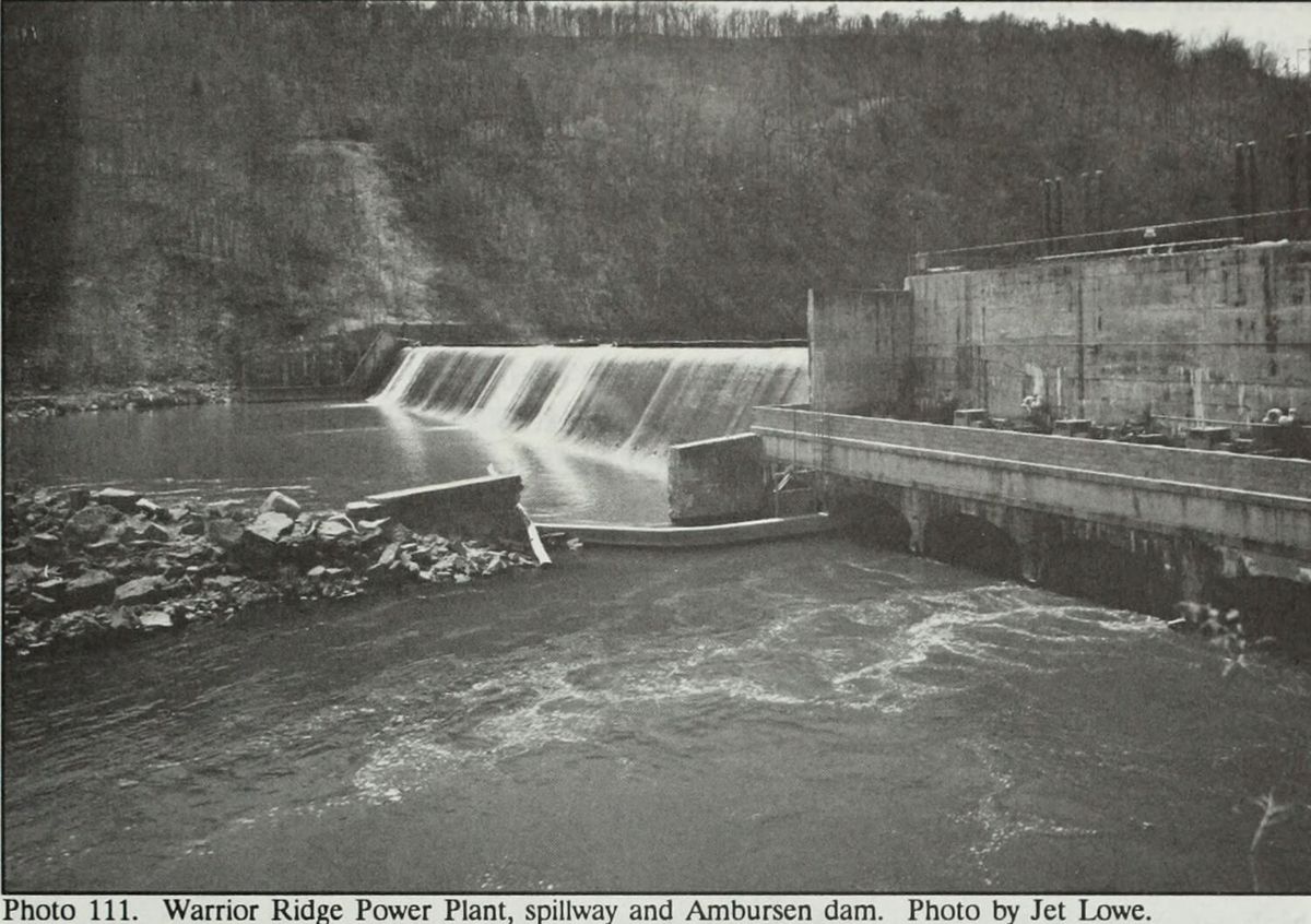
Water going over the spillway at Warrior Ridge, with the Ambursen dam and the power plant to the right.
Water going over the spillway at Warrior Ridge, with the Ambursen dam and the power plant to the right.Nancy S. Shedd et al., Huntingdon County, Pennsylvania: An Inventory of Historic Engineering and Industrial Sites (Historic American Buildings Survey / Historic American Engineering Record, National Park Service, 1991), photograph 111, photograph by Jet Lowe shd111

Two miles south of Petersburg, where the Frankstown Branch of the Juniata cuts a gap through Warrior Ridge, a hollow concrete dam and a power plant were built in 1905 to 07 for the Juniata Hydro-Electric Company of Philadelphia. William H. Cushman, the company's chief engineer, designed the power house and hydraulic installation. A.G. Wood planned the auxiliary coal fired steam plant, the General Electric Company designed the electrical installation, and the Ambursen Hydraulic Construction Company designed and built the dam.

The main dam is 400 feet long and 27 feet high, reinforced concrete with one foot plank flash boards, running from the power plant on the north bank to the steep slope of the ridge on the south. An auxiliary dam 110 feet long and of the same design was added in 1907, north of the plant. Ambursen had patented the buttressed hollow core dam in 1904. The nomination says Warrior Ridge was one of the earliest covered versions of that design and drew widespread attention in the engineering press. The Engineering Record ran it on December 22, 1906, and Huntingdon's Semi-Weekly News reprinted the article on February 14, 1907 under the headline "Description of the Wonderful Hydro-Electric Plant, Warrior Ridge."

The plant had a capacity of 8,000 horsepower and contracted to supply Huntingdon and its surrounding communities, Altoona and Tyrone. The company built four houses in 1907, three bungalows of 25 by 30 feet and one double house, and, the nomination says, a small frame church in the 1910s. The 1910 census counted a superintendent, an operator and two stationary firemen living there.

Pennsylvania Hydro Electric took the complex in 1911 when Juniata Hydro could not satisfy its mortgages. Penelec bought it in 1927 and ran both hydro and steam until 1952, when the steam plant closed and the houses were sold to individual owners. The Agnes flood of 1972 wrecked turbines and other equipment, and a major portion of the plant was demolished in 1978. A 1991 National Park Service inventory of the county's engineering sites says American Hydro Power bought the plant from Penelec in 1984 and brought it back on line in 1985 as a 2.8 megawatt station, with one original turbine, a 1906 S. Morgan Smith unit repaired after Agnes, still in its chamber. In 1989 the former church, 15 by 18 feet, was being used to treat water for the company houses.

Although electricity was produced on a small scale at isolated and scattered locations throughout the county, this operation represents the first and only large scale production in the county at this time. This permitted large scale change in industrial production to the areas served by the power company.National Register of Historic Places nomination, Warrior Ridge Dam and Hydroelectric Plant (reference 90000701), 90000701, section 8, p7 · character 11,219 of the scanned text
Checked against the record. Checked against the National Register nomination text before publication; 5 claims the nomination did not support were removed or corrected.

Open this story on its own page →

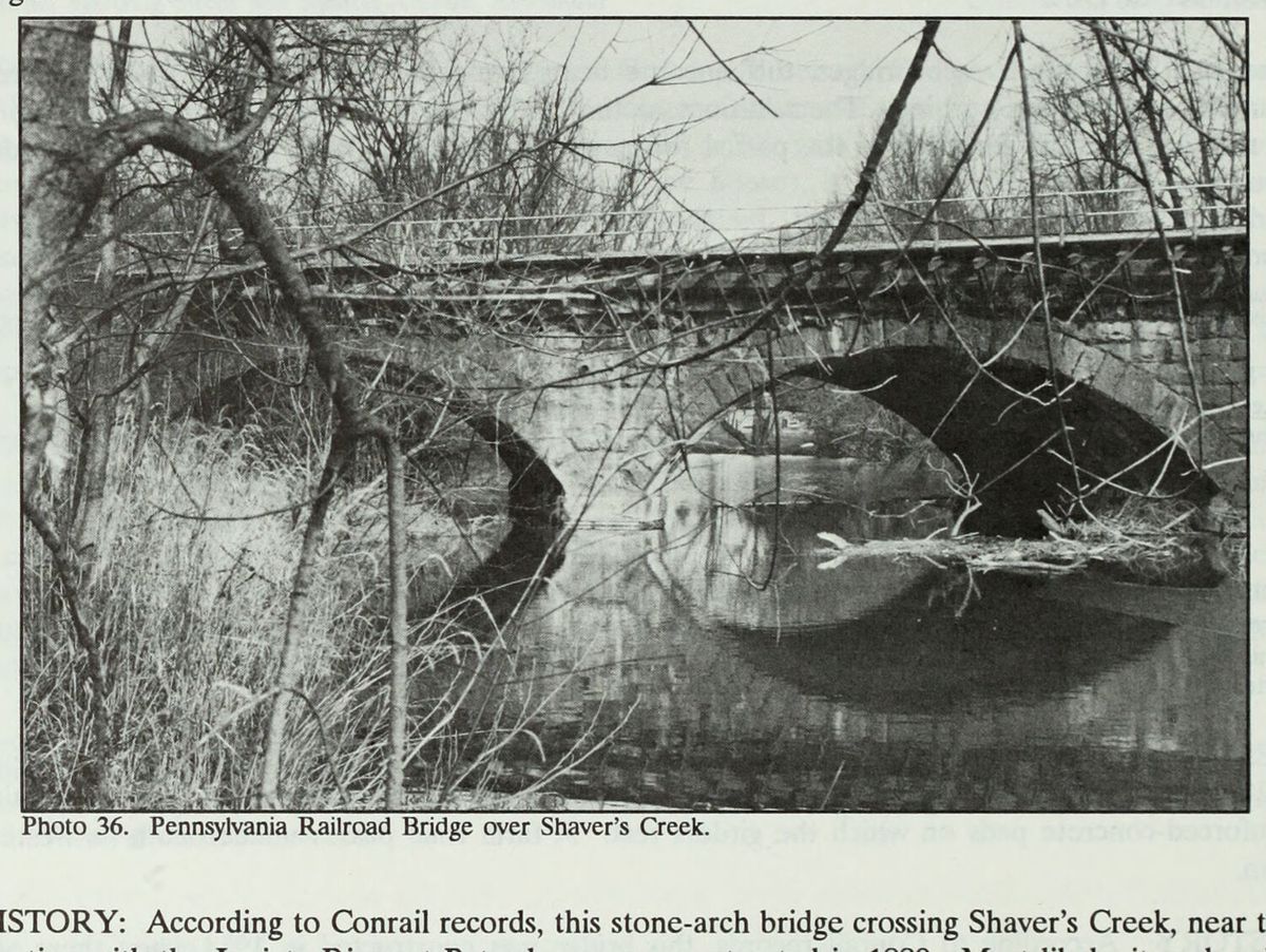
The Pennsylvania Railroad’s stone arch bridge over Shavers Creek at Petersburg.
The Pennsylvania Railroad’s stone arch bridge over Shavers Creek at Petersburg.Nancy S. Shedd et al., Huntingdon County, Pennsylvania: An Inventory of Historic Engineering and Industrial Sites (Historic American Buildings Survey / Historic American Engineering Record, National Park Service, 1991), photograph 36 shd036

At the south end of Petersburg, where Shavers Creek meets the Juniata, a three arch bridge of cut stone, 134 feet long, carries the railroad's two tracks over the creek. Its faces are cut, coursed, unfinished stone with semicircular arches, and the undersides of the arches were built with step like ribbing for support. The National Register nomination, prepared in September 1989, also lists it under the name Conrail Bridge over Shavers Creek, and the form names the Pennsylvania Railroad as its builder.

Conrail's records put its construction in 1889. The nomination says a date like that often means a bridge rebuilt after the flood of 1889, but that no evidence was found that this was the case here. The nomination says its text was taken from an unpublished report Nancy Shedd prepared in 1988 for the Historic American Engineering Record. Shedd's inventory of the county's engineering and industrial sites, printed in 1991, puts it more strongly, saying the bridge most likely replaced one lost or damaged in the flood. What the records do show is six stone arch railroad bridges built in the county between 1886 and 1889, which the nomination reads as a program by the Pennsylvania Railroad to replace its first generation of iron bridges with heavier masonry.

The most recent major repairs before the form was written, again by Conrail's records, came in 1967, which the nomination says may be when a series of triangular metal brackets was added along the south face to support curbing at the edge of the right of way. Metal safety railings on both sides of the deck were a recent addition in 1989. The nomination says it is the only stone arch railroad bridge still in use in the county whose face has not been covered with concrete supports.

It was nominated under Criteria A and C, transportation and engineering, with a period of significance from 1889 to 1939. The nomination calls it a good example of a nineteenth century multiple span stone arch bridge and of the second phase of bridge building on the Pennsylvania Railroad's right of way. The listed property is a rectangle 134 feet by about 60 feet whose corners are the outside corners of the wing walls, taking in the bridge and nothing else. Two pictures of it are cited: an early photograph on page 30 of Petersburg and Shavers Creek Valley, published by the Petersburg Bicentennial Committee in 1976, and a photograph of the bridge under construction in the John Nelson Thompson collection at the Huntingdon County Historical Society.

Rather, available records show six stone-arch railroad bridges constructed in the county between 1886 and 1889, suggesting that the PRR was engaged in a program of replacing its first-generation iron bridges with heavier masonry structures.National Register of Historic Places nomination, Pennsylvania Railroad Bridge over Shavers Creek (reference 90000395), Pennsylvania Railroad Bridge over Shavers Creek, section 8, p5 · character 5,360 of the scanned text
Checked against the record. Checked against the National Register nomination text before publication; 6 claims the nomination did not support were removed or corrected.

Open this story on its own page →

Did you know? As early as 1774, Jacob and Josiah Minor ran a grist mill on the Little Juniata, where the Barree Iron Works later stood, so simple that it was long preserved as a relic.

The pioneer millwright Edward Bell described it. The mill house was about twelve feet high and about fourteen square, made of small logs, with neither floor nor loft. The tub wheel was some three feet across. In place of a hoop around the millstones they used a hollow buttonwood tree, cut off to fit. The meal trough was made from part of a gum tree, and the bolting chest had a pair of deer skins spliced together for a door. There was not an ounce of iron about the chest or bolting reel.

In the last years of the Revolution the mill was run by lessees. One of them, Peter Crum, was killed by Indians on his way home to what is now Logan Township.

Checked and confirmed. CONFIRMED 2026-10-03 against the sources listed: every factual sentence was tied to a verbatim passage and a script confirmed each passage is in its source. Where sources disagreed on a number, the number was left out.

Open this story on its own page →

From the county histories, on Logan township. The passage below is printed exactly as it appears in 1883, including the spelling of the day and the errors the scanner made. It has not been rewritten, summarised or added to.

The cloth was of Leona muslin, or lining that looked like it." The. mill was operated in the later years of the Revolution by lessees, one of whom, Peter Crum, was killed by the Indians while proceeding to his home in the present township of Logan. After 1790, Lazarus McLain was the owner of the property, but in 1795, Edward Bartholomew, of Philadelphia, became the owner, together with a large quantity of real . estate in this locality, and turned it over to his sonin-law, Greenberry P. Dorsey, who came on to live at ' this place. wee Ke Dorsey built a small forge near the mill, which was the beginning of the present Barree Iron-Works, the old mill having all this time been kept in successful operation. From the fact that the forge was situated in the old township of Barree, a name familiar to all new-comers, it received that title, and William B. Moore, "an Irishman, became the manager. Subsequently, since so many Moores were interested in the iron-works, he was distinguished from the rest by being called Barree Billy Moore. He was a very skillful workman, and the products of the forge soon became very popular with iron-workers.J. Simpson Africa, History of Huntingdon and Blair Counties, Pennsylvania (Philadelphia: Louis H. Everts, 1883) · character 2,721,230 of the scanned text

Open this story on its own page →

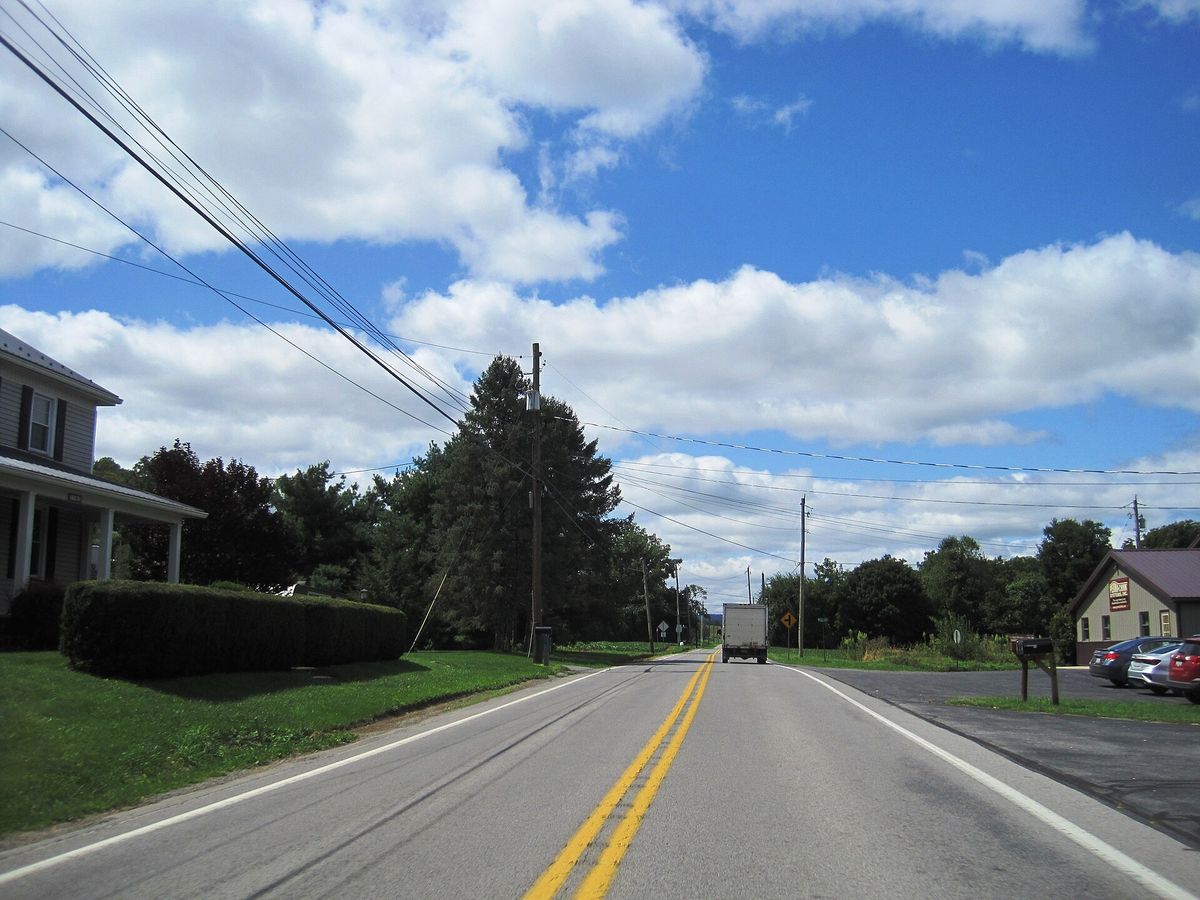
westbound Pennsylvania Route 305 (Shavers Creek Road) in the village of Ribot within Logan Township, Huntingdon County, Pennsylvania. Photo taken looking south-southwest between McMahon Road and Mill Road.
westbound Pennsylvania Route 305 (Shavers Creek Road) in the village of Ribot within Logan Township, Huntingdon County, Pennsylvania. Photo taken looking south-southwest between McMahon Road and Mill Road.Photograph by Mr. Matté, 2024-08-20. Licensed CC BY-SA 4.0; reused with credit, and the same licence travels with any derivative. PA 305 wb in Ribot, Aug. 2024.jpg

Shavers Creek Road, which is also Pennsylvania Route 305, running west through the village of Ribot in Logan township. Photographed in August 2024.

Checked against the record. Placed by the photograph's own coordinates against the Census geocoder, which returns Huntingdon / Logan.

Open this story on its own page →

Where it sits

Alexandria borough: 12 storiesBirmingham borough: 2 storiesBroad Top City borough: 2 storiesCassville borough: 2 storiesCoalmont borough: 2 storiesDudley borough: 2 storiesHuntingdon borough: 36 storiesMapleton borough: 6 storiesMarklesburg borough: 4 storiesMill Creek borough: 4 storiesMount Union borough: 137 storiesOrbisonia borough: 8 storiesPetersburg borough: 3 storiesRockhill borough: 5 storiesSaltillo borough: 5 storiesShade Gap borough: 3 storiesShirleysburg borough: 4 storiesThree Springs borough: 4 storiesBarree township: 6 storiesBrady township: 4 storiesCarbon township: 3 storiesCass township: 2 storiesClay township: 4 storiesCromwell township: 7 storiesDublin township: 5 storiesFranklin township: 10 storiesHenderson township: 6 storiesHopewell township: 5 storiesJackson township: 9 storiesJuniata township: 8 storiesLincoln township: 5 storiesLogan township: 5 storiesMiller township: 4 storiesMorris township: 2 storiesOneida township: 6 storiesPenn township: 4 storiesPorter township: 10 storiesShirley township: 10 storiesSmithfield township: 5 storiesSpringfield township: 5 storiesSpruce Creek township: 7 storiesTell township: 3 storiesTodd township: 5 storiesUnion township: 5 storiesWalker township: 9 storiesWarriors Mark township: 5 storiesWest township: 2 storiesWood township: 13 storiesHuntingdonMount UnionOrbisoniaThree SpringsPetersburgMapletonAlexandriaRockhillBroad Top CitySaltillo
10 or more4 to 91 to 3borough outline