Porter township
Pulpit Rocks and the summer the survey got the mountains right
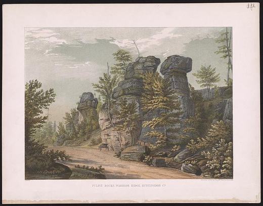
On the crest of Warrior Ridge, about a mile and a half northwest of Huntingdon along the old Huntingdon and Hollidaysburg Turnpike, weathered sandstone stands in columns named for a fancied resemblance to pulpits. Africa's 1883 county history says the elements wore the stone into grotesque shapes that attracted considerable attention as natural curiosities. I. C. White's 1885 county geology called them rock cities, isolated piles of rock fifty feet high with passageways one to ten feet wide between them.
The rock is the Oriskany sandstone, laid down in an inland sea roughly 390 million years ago. Weathering along the joints isolates the columns and leaves an almost pure sand soil never suited to farming. The site has never been mined.
It was nominated as a National Historic Landmark in 1992 for what happened here in 1836, the year Governor Joseph Ritner signed the bill creating the First Geological Survey of Pennsylvania. Henry D. Rogers, a 26-year-old professor at the University of Pennsylvania, led it, with assistants James C. Booth, 24, and John F. Frazer, 26. Frazer worked down from the Broad Top coal measures through Terrace Mountain and Tussey Mountain into Morrison's Cove and found that the sandstones holding up those two mountains were not the same rock, as geologists had thought, but were separated by thousands of feet of other layers. Rogers did not believe him at first. When Booth reported the same sequence from the Potomac in western Maryland and Rogers checked Frazer's sites himself, the three agreed at a Sunday meeting in Huntingdon that summer. The nomination says that agreement set the framework for later geologic work throughout the Appalachians, and quotes J. Peter Lesley, state geologist of the second survey, writing in 1876 that American structural geology was born in 1836.
George Lehman painted the rocks and the road in an 1840 watercolor that became the frontispiece of Rogers's final report, published in 1858, and the nomination says the road, rocks and vegetation look much as they did then. Most of the site belongs to Juniata College, given by the Africa family under a deed requiring preservation in perpetuity; the rest is owned by the John V. Eisenberg heirs and used by a local game and hunt club. On September 26, 1986, the Field Conference of Pennsylvania Geologists and the college dedicated a plaque on the principal pulpit nearest the road.
Upon the upper plateau of the Warrior Ridge the traveller will see piles of blocks, called the Pulpit Rocks, remnants of the once more widely outspread upper strata, reared in rude columns one upon another.National Register of Historic Places nomination, Pulpit Rocks (reference 93001614), Henry D. Rogers, final report of the First Geological Survey (1858), as quoted in the National Historic Landmark nomination for Pulpit Rocks, page 3 · character 4,305 of the scanned text
Sources
- National Register of Historic Places nomination: Pulpit Rocks, reference 93001614 (1992)
- Africa, History of Huntingdon and Blair Counties (1883), Porter Township
- White, The Geology of Huntingdon County (1885), p. 215
Checked 2026-09-05 · National Register of Historic Places nomination, read in full
← All stories from Porter township
Have something to add to this story, or a photograph of it? Send it here →
More from Porter township
On the north bank of the Little Juniata, opposite the village of Barree and two miles north of Alexandria, a field…
Porter township, The Hatfield iron works below AlexandriaEast of Alexandria, between the Frankstown Branch of the Juniata and the old canal bed, six buildings remain of the…
Logan township, The hollow dam at Warrior RidgeTwo miles south of Petersburg, where the Frankstown Branch of the Juniata cuts a gap through Warrior Ridge, a hollow…