Huntingdon County Information Page

Township · Huntingdon County

Jackson

9 stories on file, each with its sources. 72.5 square miles of land in the ridge and valley country of central Pennsylvania.

859
Population
2020 Census, P.L. 94-171
72.49 sq mi
Land area
2020 Census gazetteer
0.03 sq mi
Water
2020 Census gazetteer
Township
Type
GEOID 4206137384

Nearby

Straight-line miles between map centers, 2020 Census boundary file

The founding record

Jackson township, situated in the western part of the county, was erected in 1844, the greater part of its territory being taken from Toboyne. At the November term in 1843 the court received a petition asking for the formation of a new township. Viewers were appointed and on August 8, 1844, two of them , Jacob Bernheisel and W. B. Anderson, reported in favor of granting the prayer of the petitioners. They recommended the following boundaries for the new township: "Beginning at the county line on top of the Tuscarora mountain; thence south 30 degrees east, nine miles one hundred and twenty perches through mountain land of Peter Shively, John Baker, Daniel Kern, Jacob Kreamer, Peter Smith, John Long, and others to the Cumberland county line; thence along the said county line on the top of the Blue mountain to the Madison township line; thence along the said township line to the top of the Tuscarora mountain and Juniata county line; thence along the county line and on top of Tuscarora mountain to the place of beginning." As thus constituted Jackson township extends entirely across the county, being bounded on the north by Juniata county ; on the east by Madison township; on the south by Cumberland county; and on the west by the township of Toboyne. John W. Jordan, ed., History of the Juniata Valley and Its People (New York: Lewis Historical Publishing, 1913) · character 502,750 of the scanned text
JACKSON is one of the border townships of the county, occupying the upper parts of Shaver's Creek and Standing Stone Valleys. On the west and north is Centre County, Mifflin County forming the eastern boundary. On the south is Miller township, and on the west Barree. The greatest portion of the area is mountainous, seven distinct ranges appearing in the northern and eastern parts. Of these, Tussey Mountain and Standing Stone Mountain are dividing ridges between Huntingdon and Centre and Mifflin Counties, The intermediate and parallel ridges are Shaver's Creek Ridge, Greenlee Mountain, Long Mountain, Bare Meadow Mountain, and Broad Mountain. These confine the tillable lands to the southeastern part of the township, except a few narrow vales between the ranges named. The latter were originally heavily timbered, chiefly by pine-trees, although a large area of timber land yet remains upon some of the higher ridges. Bare Meadow Mountain owes its name to the fact that it is an almost treeless plateau, with a surface soft and yielding, being somewhat of the nature of swampy lands. In the valleys the soil is usually fertile and in some localities it is underlaid by limestone.J. Simpson Africa, History of Huntingdon and Blair Counties, Pennsylvania (Philadelphia: Louis H. Everts, 1883) · character 1,900,334

Quoted from a work published before 1929 and therefore in the public domain in the United States. Spelling and punctuation are as printed, including nineteenth century spellings of place names. Scanned text carries optical character recognition errors; the character offset is given so the passage can be found and checked in the original.

9 stories

Stories from Jackson

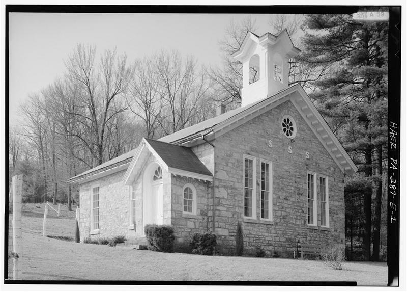
Greenwood Furnace, Church, East of McAlevy's Fort on State Route 305, McAlevys Fort
Greenwood Furnace, Church, East of McAlevy's Fort on State Route 305, McAlevys FortLibrary of Congress, Historic American Buildings Survey / Historic American Engineering Record. No known copyright restrictions. pa2915

The church at Greenwood Furnace is a one-story building of rubble stone, gable end to the road, with a side entrance porch and a cross-gabled cupola. The Historic American Engineering Record photographed it as one part of its Greenwood Furnace survey. Its own data pages are a single cover sheet; the written history belongs to the parent survey, compiled by Gray Fitzsimons and Kenneth Rose, which cites an interview with the park superintendent in July 1988, dates the church to 1865 and lists it, with the cemetery, among the structures that survive from the years of iron production.

Two older histories fill in what the cover sheet leaves out. Jordan's 1913 History of the Juniata Valley and its People says Methodist churches were built in 1865 at Loysville, Ennisville and Greenwood Furnace, and that the Greenwood Furnace church, a substantial stone structure, was not dedicated until 1867. J. Simpson Africa, writing in 1883 while the furnace was still in blast, listed a good schoolhouse and a fine Methodist church among the things that made Greenwood an attractive mountain village.

The 1989 National Register nomination for Greenwood Furnace describes the building as it stood then: gable front facing Route 305, the door on the eastern side four-paneled with a fanlight above, six-over-six windows in front and nine-over-nine on the sides, cleaned and repointed in 1980. The county's 1991 inventory of historic engineering and industrial sites remarks that documents place schools and churches at many of the county's iron works but that almost none survive, and names the Civil War-era stone church at Greenwood as one of the exceptions.

The survey says the stacks, church and cemetery are maintained as historic sites and interpreted for park visitors. The cemetery lies four tenths of a mile west of the church on the south side of Route 305. The nomination says two Revolutionary War and several Civil War veterans are known to have been buried there, and that its limestone markers do not lie in a regular arrangement.

Checked against the record. Checked against the survey's written record before publication; 4 claims it did not support were removed or corrected.

Open this story on its own page →

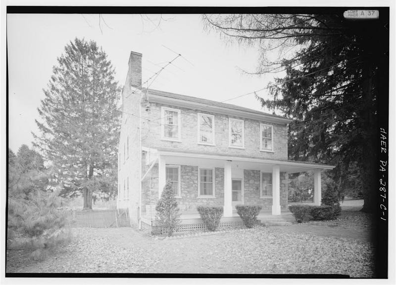
Greenwood Furnace, Ironmaster's Mansion, East of McAlevy's Fort on State Route 305, McAlevys Fort
Greenwood Furnace, Ironmaster's Mansion, East of McAlevy's Fort on State Route 305, McAlevys FortLibrary of Congress, Historic American Buildings Survey / Historic American Engineering Record. No known copyright restrictions. pa2913

Five miles east of McAlevys Fort on Route 305, the ironmaster's mansion at Greenwood Furnace is a four-bay, two-story house of coursed stone rubble with a two-story rear ell under a half-gable roof. The Historic American Engineering Record photographed it as one part of its Greenwood Furnace survey. The photographs carry only a cover sheet; the written history belongs to the parent survey, a 1988 report edited by Gray Fitzsimons and Kenneth Rose, whose author the 1989 National Register nomination names as Nancy Shedd. That report dates the house to the furnace's founding year, when Norris, Rawle and Company established the works and John Hagey contracted to construct the furnace.

J. Simpson Africa's 1883 county history tells the beginning differently. It names the proprietors as Judge Rawle and James Hall, says the furnace was begun in the fall of 1832 and not put in blast until June 5, 1834, and says Hall, the resident partner, built the furnace mansion the year before the first blast and occupied it about a dozen years. The survey and Africa differ by a year on when the house went up.

The survey lists what changed afterward. Early photographs show the walls under a plaster coating, since removed. Two external chimneys were added, and probably the little bay on the south side. The interior, the survey says, is said to be much altered. The 1989 National Register nomination for Greenwood Furnace, which draws on the same HAER report, adds that the south bay was built as a kitchen, that a wooden porch runs across the front, and that access to the interior was denied.

The house outlived the works it managed. The survey calls Greenwood the last Huntingdon County furnace to go out of blast, with the final blast in December 1904; the state acquired the land for reforestation soon afterward, opened a tree nursery in 1905 and a state park in 1930. In 1883 Africa counted at Greenwood, besides the furnace and what he called the fine mansion, offices, mills and about ninety good tenements, with work for nearly two hundred men.

Checked against the record. Checked against the survey's written record before publication; 3 claims it did not support were removed or corrected.

Open this story on its own page →

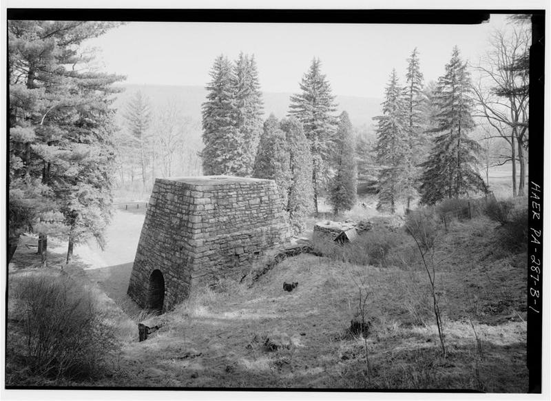
Greenwood Furnace, Stack No. 2, East of McAlevy's Fort on State Route 305, McAlevys Fort
Greenwood Furnace, Stack No. 2, East of McAlevy's Fort on State Route 305, McAlevys FortLibrary of Congress, Historic American Buildings Survey / Historic American Engineering Record. No known copyright restrictions. pa2912

Five miles east of McAlevys Fort on Route 305, the second of Greenwood Furnace's two stacks stands with its four arches open, and the Historic American Engineering Record filed its photographs of the stack as HAER PA-287-B. The record's written history of the site is in the parent report, PA-287, and that report is where the stack's story sits.

J. Simpson Africa's 1883 county history says Greenwood was begun in the fall of 1832, that building material was hard to come by, and that it was not put in blast until June 5, 1834. He names the proprietors as Judge Rawle and James Hall. The survey dates the establishment to 1834 by Norris, Rawle and Co., a firm that had recently acquired the Freedom Iron Works near Lewistown and wanted pig iron to refine at Freedom Forge. It says John Hagey contracted to build the furnace and that the stone stack was first assessed in 1835 at $10,000.

The second stack went up in the 1860s. The survey gives two different years for it and the county history a third, so this story gives none. By 1870, the survey reports, the works had $400,000 invested, 230 men employed and more than 3,000 tons of iron produced, which it calls the county's largest iron operation. Freedom Iron Company later became Logan Iron and Steel Co., which ran the furnace until 1904, and the survey says it was the last Huntingdon County furnace to go out of blast.

The survey describes Stack No. 2 as a 30 by 30 by 30 foot stack of coursed sandstone blocks, reconstructed in 1936 by the Civilian Conservation Corps, with its four arches left open to walk through, the crucible exposed, the stack open to the top and the furnace capped with concrete. Stack No. 1, the 1834 stack, is a ruin about 15 feet high, excavated about 1976.

The Pennsylvania Department of Forest and Waters acquired the furnace lands for reforestation soon after the last blast in December 1904. A state tree nursery followed at Greenwood in 1905, and a state park in 1930.

Checked against the record. Checked against the survey's written record before publication; 6 claims it did not support were removed or corrected.

Open this story on its own page →

A Greenwood Furnace stack, which Myer Souders labels Stack No. 2
A Greenwood Furnace stack, which Myer Souders labels Stack No. 2Shared by Myer Souders

Did you know? The furnaces at Greenwood ran on charcoal, and it took around 330 acres of forest a year to make it.

Colliers burned the wood on hearths to make the charcoal, the state park's history says, and hundreds of those hearths can still be found in the park and on the hillsides around it. Look for large, flat circles where little grows.

Two stacks stood there. The ruins of the first, from about 1834, are about fifteen feet high. The second, built in 1868, is a thirty foot stack of coursed sandstone blocks, and the Civilian Conservation Corps reconstructed it in 1936, leaving its four arches open to walk through.

Myer Souders shared this photograph, which he labels Stack No. 2 at Greenwood Furnace, and he reminds us how hard those furnaces were on our forests.

Checked and confirmed. CONFIRMED 2026-10-09 against the sources listed: every factual sentence was tied to a verbatim passage and a script confirmed each passage is in its source. Information shared with us by readers is given as theirs, not as fact: Myer Souders.

Open this story on its own page →

Whipple Dam State Park covers 244 acres of Jackson Township, ringed by Rothrock State Forest, according to the nomination stamped in at the National Register in January 1987. The lake at its center is man-made, and the nomination says the dam holding it is the third on the site: the first, it says, was built by the Whipple family to run a sawmill, the state replaced it in 1927, and the CCC replaced that one in 1936. The 1991 county inventory of engineering and industrial sites tells the early part differently, saying Laurel Run was once dammed near the present dam to power Little's, or Lytle's, sawmill.

The CCC is why the day use area was listed. "CCC Camp S-60 developed Whipple Dam State Park between 1933 and late 1941. The present dam, constructed by the CCC in 1936, is the third dam at this site" (nomination, p1). The form counts ten buildings and nine structures around the lake, all contributing: a clapboard concession building, a log storage building with saddle corners and white cement chinking, eight latrines, three picnic pavilions on log columns and stone piers, the large gabled one with a stone fireplace on its rear wall, and four small shelters, one on stone piers that carry a fixed picnic table and benches. The last two structures are the dam, with its offset spillway, and a small steel automobile bridge with stone abutments and a wooden deck.

The nomination calls this the rustic style the National Park Service espoused, built of local, natural materials to blend with the natural environment, and says the district appears to meet Criteria A and C as work of the Civilian Conservation Corps, a New Deal relief effort that employed thousands of jobless young men.

The inventory adds what the form leaves out. The dam impounds Laurel Run. The site had no power lines, so the dam was designed with a small plant to light the park, obsolete once rural electric lines reached the area in the early 1940s. The inventory also names the man behind the name: Osgood Whipple, the last private owner of the tract. The 1897 Commemorative Biographical Encyclopedia of the Juniata Valley says Whipple was born in Westford, Vermont, served in the First Vermont Cavalry, and in 1878 bought 1,400 acres in Jackson Township of timber land, cleared land and mills. By 1897 he was proprietor of the McAlevys Fort Hotel.

CCC Camp S-60 developed Whipple Dam State Park between 1933 and late 1941. The present dam, constructed by the CCC in 1936, is the third dam at this site.National Register of Historic Places nomination, Whipple Dam State Park Day Use District (reference 87000109), p1 · character 2,085 of the scanned text
Checked against the record. Checked against the National Register nomination text before publication; 10 claims the nomination did not support were removed or corrected.

Sources

  1. National Register of Historic Places nomination: Whipple Dam State Park Day Use District, reference 87000109 (1986)
  2. Huntingdon County, Pennsylvania: An Inventory of Historic Engineering and Industrial Sites (Nancy S. Shedd, National Park Service, 1991), Whipple Dam entry
  3. Commemorative Biographical Encyclopedia of the Juniata Valley (1897), Osgood M. Whipple

Open this story on its own page →

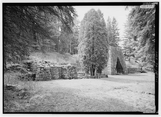
Greenwood Furnace, East of McAlevy's Fort on State Route 305, McAlevys Fort
Greenwood Furnace, East of McAlevy's Fort on State Route 305, McAlevys FortLibrary of Congress, Historic American Buildings Survey / Historic American Engineering Record. No known copyright restrictions. pa2910

Five miles east of McAlevys Fort on Route 305, in the northeastern part of the county, the stacks of Greenwood Furnace, one rebuilt and one a ruin, stand inside a state park named for it. The nomination calls the place an iron plantation: a furnace with the mansion, church, worker housing, tavern, mill, tramway and mines that kept it running.

The nomination says Greenwood was established in 1834 by Norris, Rawle and Co., who had recently acquired the Freedom Iron Works near Lewistown and wanted pig iron to refine at Freedom Forge, and that large tracts of virgin timber for charcoal apparently dictated the remote site. J. Simpson Africa's 1883 county history names the proprietors as Judge Rawle and James Hall, and says Hall became the resident partner, built the furnace mansion and lived in it about a dozen years.

The stone stack was first assessed in 1835 at $10,000. By 1850 the works employed 73 men and 34 horses and mules and made 1,600 tons of pig iron a year. Ownership passed in 1849 to John A. Wright and Co., and later to a reorganized Freedom Iron Co. A second stack was added, and an 1870 report counted 230 men and 3,096 tons of iron, which the nomination says made it the county's largest iron operation. Africa in 1883 found about ninety tenements, nearly two hundred men employed, and a stone Methodist church built in 1865. Freedom Iron became Logan Iron and Steel Co. and kept Greenwood in blast until December 1904; the nomination calls it the last charcoal furnace in Huntingdon County to go out of blast.

The Commonwealth acquired the land for reforestation soon after, opened a state tree nursery in 1905 and a state park in 1930. The Civilian Conservation Corps rebuilt Stack No. 2 in 1936, mortaring the stones for stability and leaving its four arches open to walk through. The ironmaster's mansion, the 1865 church and a log meat house with the hooks still in its ceiling survive, along with the foundations of three rows of worker houses called Colliers, Creek and Griffith Row. The district was listed under Criteria A and D, for the industry and for what digging may still reveal. West of the mill site the tramway right-of-way can be followed about two and a half miles, with mines and spoil piles visible on either side along its last three quarters of a mile.

Originally, iron ore and some of the limestone needed was hauled to the furnace from the Mifflin County side of Stone Mountain, and the iron hauled some thirteen miles back over the mountain to the forge. Later, discovery of ore deposits closer to the furnace eliminated some of this difficult labor.National Register of Historic Places nomination, Greenwood Furnace (reference 89001819), section 8, p. 8 · character 13,268 of the scanned text
Checked against the record. Checked against the National Register nomination text before publication; 5 claims the nomination did not support were removed or corrected.

Open this story on its own page →

Greenwood Furnace State Park, as the survey form described it in 1986, was an area of 334 acres inside Rothrock State Forest. The Pennsylvania Department of Forests and Waters first developed it as a Class A campground between 1922 and 1925. In May 1933 the Civilian Conservation Corps established Camp S-59 in the park and set to work on more recreational facilities, among them the dam that holds Greenwood Lake. The camp remained active until October 1935, and the dam went up between 1933 and 1935.

The dam has a reinforced concrete core faced with stone, which the survey form says was done to give it a rustic look in keeping with the policies and philosophy of the National Park Service. There is a spillway at each end, and a stone control tower with a gabled roof stands beside the western one. The dam measures 130 feet on its north and south sides and 25 feet on its east and west ends. It was the only thing nominated: the form says the park's other CCC-built facilities had lost their original integrity.

The form was prepared by John Milner Associates of Philadelphia from a 1983 survey, and the dam went forward as part of a thematic group, Emergency Conservation Work Architecture in Pennsylvania State Parks, 1933 to 1942, under Criteria A and C. The form ties the dam to the CCC as one of the federal relief programs of the New Deal and to the rustic style of park building, in which modern materials such as reinforced concrete were often masked behind rusticated stone. It notes that the structure had by then served as a recreational facility for approximately fifty years. The National Park Service evaluation sheet is stamped January 5, 1987.

A 1991 National Park Service inventory of the county's historic engineering and industrial sites adds what the dam did besides hold a lake for day use: it worked with a small turbine and generator to produce electricity for the park before commercial electric service reached the area. As of that inventory, the small stone generating tower remained at the breast of the dam, and the turbine and generator, removed from the tower, were in storage at the park.

The structure's principal feature is a rectangular control tower, constructed of randomly laid ashlar. The tower, which is adjacent to the western spillway, has a gabled roof with exposed rafters.National Register of Historic Places nomination, Greenwood Lake Dam (reference 87000050), Pennsylvania Historic Resource Survey Form, item 26 continued, p. 2 · character 13,235 of the scanned text
Checked against the record. Checked against the National Register nomination text before publication; 6 claims the nomination did not support were removed or corrected.

Open this story on its own page →

Did you know? Iron made in Huntingdon County left here by wagon and came back as railroad wheels.

By the early 1880s Greenwood Furnace was topping three thousand tons of charcoal iron a year, which the state calls one of the largest charcoal furnace operations in Pennsylvania. The iron was hauled by wagon over Stone Mountain to the Freedom Iron Works to be turned into wrought iron.

At Freedom Iron, starting in 1856, they were making locomotive tires, railroad car wheels and axles for the booming railroads, using iron produced at the Greenwood works. John A. Wright and Company had bought the Greenwood works back in 1847. John Armstrong Wright was a civil engineer who helped found the Pennsylvania Railroad and the city of Altoona.

Greenwood Furnace State Park is still there. Six of the original buildings and the cemetery remain, the mansion, the church, and the blacksmith and wagon shop among them. Furnace Stack Number 2 was restored as a monument in 1936.

Wagons over a mountain, and the results rolled out under trains.

Has your family got Greenwood in it? The cemetery is still up there.

Checked against the record. CORRECTED. The post was largely right and one detail was wrong in a way a visitor would notice from the parking lot. CONFIRMED from PA DCNR: iron production topped 3,000 tons annually by the early 1880s, and DCNR adds the detail the original omitted, that this made it one of the largest charcoal furnace operations in the state. Freedom Iron began producing locomotive tires, railroad car wheels and axles in 1856 'util…

Open this story on its own page →

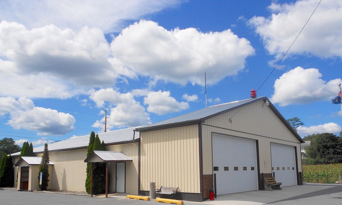
Stone Creek Valley Volunteer Fire Department Station 19 on Route 26 in Huntingdon County, Pennsylvania
Stone Creek Valley Volunteer Fire Department Station 19 on Route 26 in Huntingdon County, PennsylvaniaPhotograph by the Wikimedia Commons contributor Smallbones, 2016-09-02. Released under CC0, a public domain dedication. Stone Creek Valley Vol Fire Dept No 13.jpg

The Stone Creek Valley Volunteer Fire Department, Station 19, on Route 26 in Jackson township. Photographed in September 2016 and released into the public domain.

Checked against the record. Placed by the photograph's own coordinates against the Census geocoder, which returns Huntingdon / Jackson.

Open this story on its own page →

Where it sits

Alexandria borough: 12 storiesBirmingham borough: 2 storiesBroad Top City borough: 2 storiesCassville borough: 2 storiesCoalmont borough: 2 storiesDudley borough: 2 storiesHuntingdon borough: 36 storiesMapleton borough: 6 storiesMarklesburg borough: 4 storiesMill Creek borough: 4 storiesMount Union borough: 137 storiesOrbisonia borough: 8 storiesPetersburg borough: 3 storiesRockhill borough: 5 storiesSaltillo borough: 5 storiesShade Gap borough: 3 storiesShirleysburg borough: 4 storiesThree Springs borough: 4 storiesBarree township: 6 storiesBrady township: 4 storiesCarbon township: 3 storiesCass township: 2 storiesClay township: 4 storiesCromwell township: 7 storiesDublin township: 5 storiesFranklin township: 10 storiesHenderson township: 6 storiesHopewell township: 5 storiesJackson township: 9 storiesJuniata township: 8 storiesLincoln township: 5 storiesLogan township: 5 storiesMiller township: 4 storiesMorris township: 2 storiesOneida township: 6 storiesPenn township: 4 storiesPorter township: 10 storiesShirley township: 10 storiesSmithfield township: 5 storiesSpringfield township: 5 storiesSpruce Creek township: 7 storiesTell township: 3 storiesTodd township: 5 storiesUnion township: 5 storiesWalker township: 9 storiesWarriors Mark township: 5 storiesWest township: 2 storiesWood township: 13 storiesHuntingdonMount UnionOrbisoniaThree SpringsPetersburgMapletonAlexandriaRockhillBroad Top CitySaltillo
10 or more4 to 91 to 3borough outline