Huntingdon County Information Page

Township · Huntingdon County

Henderson

6 stories on file, each with its sources. 26.2 square miles of land in the ridge and valley country of central Pennsylvania.

922
Population
2020 Census, P.L. 94-171
26.16 sq mi
Land area
2020 Census gazetteer
0.13 sq mi
Water
2020 Census gazetteer
Township
Type
GEOID 4206133808

Nearby

Straight-line miles between map centers, 2020 Census boundary file

The founding record

Henderson township, established in November, 1814, was formed from part of ol0 Huntingdon township, which was one of the six in existence when the county was erected. It was named for General Andrew Henderson, a Revolutionary soldier, the first register and recorder and the second prothonotary of the county. The original area of Henderson township has been greatly reduced by the erection of Brady, in 1846, and of Oneida in 1856. It is bounded on the northwest by Oneida township; on the northeast by Barree; on the east by Brady; extends southwest to the Juniata river, and adjoins the borough of Huntingdon. Among the early settlers was John Fee, who served in Captain Blair's company that was organized during the Revolution to drive out the Tories. Gorsuch and Union Church, near the center of the township, and Ardenheim, a small station on the Pennsylvania railroad, two miles east of Huntingdon, are the only villages of consequence. John W. Jordan, ed., History of the Juniata Valley and Its People (New York: Lewis Historical Publishing, 1913) · character 186,991 of the scanned text

Quoted from a work published before 1929 and therefore in the public domain in the United States. Spelling and punctuation are as printed, including nineteenth century spellings of place names. Scanned text carries optical character recognition errors; the character offset is given so the passage can be found and checked in the original.

6 stories

Stories from Henderson

East of Huntingdon, on the northeast bank of the Juniata just below where the Raystown Branch comes in, two parallel stone walls run for 90 feet, eight feet high and 15 feet apart. They are the guard lock of the Raystown Branch feeder on the Juniata Division of the Pennsylvania Canal, which the nomination dates to 1831. Vertical slots cut at two to three foot intervals along their whole length show where timbers were set to carry the horizontal planking that lined the lock's walls and floor.

On November 19, 1828, contracts were let for the canal between Lewistown and Huntingdon. Uriah Wickwire was named to build the Raystown Branch feeder and Dearmond, Rodearmel and Company the dam; Africa's 1883 county history prints the same awards under the same date. The dam ran from the outer lock wall across the river by way of a midstream island. Its job, with the feeder, was to hold the canal at its proper level from here east to Newton Hamilton, where the next feeder dam stood. The nomination explains a guard lock's two uses: open, it let river water in to replace what leaked and evaporated; closed in high water, it kept floods out of the canal.

Boats built on Standing Stone Creek also came into the canal through it. The nomination says: "A boat built on Standing Stone Creek for Hill and Mayland of Huntingdon entered the newly completed canal by this route on May 18, 1831, and was towed up to the town." Africa's history tells the same story and adds that the day was a Wednesday.

The feeder was abandoned when the canal closed in the 1870s. Beyond the lock walls remain stone and earth remnants of the dam from the lock wall out to the island, and an earthen channel, nine tenths of a mile by the nomination's measure, ending in tumbled stonework where the feeder joined the canal proper.

The nomination form, prepared in September 1989, lists the site under Springfield Township. Its text was taken from Nancy Shedd's 1988 county survey for the Historic American Engineering Record, and that survey as published in 1991 places the site in Henderson Township. Joe Clark of Mount Union, who had walked and photographed the whole Juniata Division and was interviewed for the survey in November 1988, called it the best preserved canal remain in Huntingdon County.

A boat built on Standing Stone Creek for Hill and Mayland of Huntingdon entered the newly completed canal by this route on May 18, 1831, and was towed up to the town.National Register of Historic Places nomination, Pennsylvania Canal Guard Lock and Feeder Dam, Raystown Branch (reference 90000394), Pennsylvania Canal Guard Lock and Feeder Dam, Raystown Branch, section 8, p6 · character 8,029 of the scanned text
Checked against the record. Checked against the National Register nomination text before publication; 7 claims the nomination did not support were removed or corrected.

Open this story on its own page →

Did you know? A Henderson Township man volunteered on Commodore Perry's squadron on Lake Erie, and Pennsylvania gave him a silver medal for it.

In the fall of 1813, when the vessels of Perry's squadron were completed, volunteers were sought to fill out the crews. A number of Pennsylvania militia offered their services and were accepted. By resolutions approved January 31, 1814, the Legislature thanked the commodore and the Pennsylvanians who volunteered, and directed the Governor to present each of them, "in compliment of their patriotism and bravery, a silver medal of the weight of two dollars," with his name on it.

George Grady, a member of Capt. William Morris' company and a resident of Henderson Township, received one.

Checked and confirmed. CONFIRMED 2026-10-03 against the sources listed: every factual sentence was tied to a verbatim passage and a script confirmed each passage is in its source. Where sources disagreed on a number, the number was left out.

Open this story on its own page →

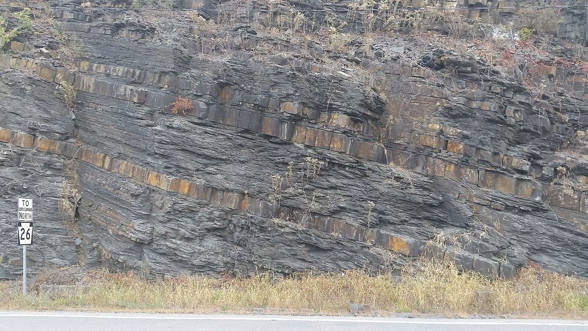
Exposure of the Devonian Brallier Formation in Huntingdon, Pennsylvania, along the ramp from U.S. Route 22 west to Pennsylvania Route 26 north. Facing roughly northeast. Thick blocky beds are sandstone and the intervenin
Exposure of the Devonian Brallier Formation in Huntingdon, Pennsylvania, along the ramp from U.S. Route 22 west to Pennsylvania Route 26 north. Facing roughly northeast. Thick blocky beds are sandstone and the intervening layers are shale. Taken at the 82nd Annual Field Conference of Pennsylvania GePhotograph by the Wikimedia Commons contributor Jstuby, 2017-10-06. Released under CC0, a public domain dedication. Brallier Formation Route 26 Huntingdon Pennsylvania.jpg

An exposure of the Devonian Brallier Formation, cut open where the ramp carries traffic from Route 22 west onto Route 26 north, facing roughly north-east. The thick blocky beds are sandstone and the layers between them are shale. It was photographed at the 82nd Annual Field Conference of Pennsylvania Geologists. The road cut is signed for Huntingdon; the rock itself is in Henderson township.

Checked against the record. Placed by the photograph's own coordinates against the Census geocoder, which returns Huntingdon / Henderson.

Open this story on its own page →

From the county histories, on Henderson township. The passage below is printed exactly as it appears in 1883, including the spelling of the day and the errors the scanner made. It has not been rewritten, summarised or added to.

Stephen Kelley, a half-brother of James, settled on Pike Run, in Henderson township. The names of other pioneers appear in the assessment of Huntingdon township in and 1802, and of Henderson in 1820. Mordecai Gosnell commenced an improvement on the tract of land that included the mouth of Mill Creek in the spring of 1766, and was residing there when the official survey was made on the 20th of June of that year. This family name is often incorrectly pronounced Goslin. The stream now known as Mill Creek was designated by the early residents as Goslin Run, The branch that issues from Kishacoquillas Valley was often called Beaver Creek. It was so known as early as 1774. After Joseph Pridmore had built his grist-mill, which stood near the site of the furnace, the main stream was known as Pridmore's Mill Creek, and when Caleb Armitage became proprietor the name was changed to Armitage's Mill Creek. John Haun, of Juniata township, mentioned above, in a conversation with the writer Aug. 7, 1871, detailed his early experiences in Brady. From his statement the following facts are noted: The Haun! family, consisting of the father John, Juliana, his wife, Jacob, a son born Oct. 22, 1789, and John (the narrator), second son, born Aug. 3, 1791, moved in a wagon from Codorus township, York Co., in 1793, and settled on the Mill Creek farm owned by John Wartz.J. Simpson Africa, History of Huntingdon and Blair Counties, Pennsylvania (Philadelphia: Louis H. Everts, 1883) · character 1,441,701 of the scanned text

Open this story on its own page →

From the county histories, on Henderson township. The passage below is printed exactly as it appears in 1913, including the spelling of the day and the errors the scanner made. It has not been rewritten, summarised or added to.

In 1858 Mount Zion church, in Henderson township, Huntingdon ■county, was organized. For years prior to that time the Lutherans living in the vicinity of Mill Creek had been attending church at Belleville or McAlevy's fort. In they leased the old Baptist church at Mill Creek and organized a congregation. Its official name is St. Stephen's, but it is generally called the Licking Creek church. Water Street church was organized early in the nineteenth century. In 1868 a number of members of this congregation who lived near Petersburg withdrew and organized the Evangelical Lutheran church in that borough.John W. Jordan, ed., History of the Juniata Valley and Its People (New York: Lewis Historical Publishing, 1913) · character 887,185 of the scanned text
Checked against the record. DATES PUT BACK, and they were this site's own doing rather than the scanner's. The passage below promises to print the record exactly as it appears, and it was doing so apart from one thing: sentences kept losing their year. “In an imposing brick church” for “In 1877 an imposing brick church”, “organized in by Rev. Richard Allen” for “organized in 1816 by”. The cause was a rule meant to strip page numbers where a ru…

Open this story on its own page →

From the county histories, on Henderson township. The passage below is printed exactly as it appears in 1876, including the spelling of the day and the errors the scanner made. It has not been rewritten, summarised or added to.

The nearest railroad stations are Shirleysburg and Orbisonia, on the East Broad Top railroad. Although thickly settled, it has no large towns or villages. The post offices are Nossville and Shade valley. Henderson township, as shown by the order of the court erecting it, was so named "in consideration of the distinguished uprightness of the late General Andrew Henderson as a public officer, and his services during the Revolutionary war." It is bounded on the northwest by Oneida township, on the southwest by the Juniata river, on the northeast by Barree township, and on the east by Brady. Adjoining the borough of Huntingdon, the people find there a market for their produce, and are benefited in many respects by being in the vicinity of a town of its size and population. Many of them are accommodated at its post-office and others at Union Church, the only post-office in the township. Porter township, erected at the same sessions of the court with Henderson, November, 1814, was named in "consideration of the distinguished uprightness of the late General Andrew Porter, Surveyor General, as a public officer, and his services during the Revolutionary war." The township very irregular shape, having the general form of an equilat800 eral triangle. The sides are much indented, especially on the northeast, where it follows the coarse of the Juniata river. Its other boundaries are the Tussey mountains on the northwest, and Blair county and Walker township on the south.Milton Scott Lytle, History of Huntingdon County (Lancaster: William H. Roy, 1876) · character 581,335 of the scanned text

Open this story on its own page →

Where it sits

Alexandria borough: 12 storiesBirmingham borough: 2 storiesBroad Top City borough: 2 storiesCassville borough: 2 storiesCoalmont borough: 2 storiesDudley borough: 2 storiesHuntingdon borough: 36 storiesMapleton borough: 6 storiesMarklesburg borough: 4 storiesMill Creek borough: 4 storiesMount Union borough: 137 storiesOrbisonia borough: 8 storiesPetersburg borough: 3 storiesRockhill borough: 5 storiesSaltillo borough: 5 storiesShade Gap borough: 3 storiesShirleysburg borough: 4 storiesThree Springs borough: 4 storiesBarree township: 6 storiesBrady township: 4 storiesCarbon township: 3 storiesCass township: 2 storiesClay township: 4 storiesCromwell township: 7 storiesDublin township: 5 storiesFranklin township: 10 storiesHenderson township: 6 storiesHopewell township: 5 storiesJackson township: 9 storiesJuniata township: 8 storiesLincoln township: 5 storiesLogan township: 5 storiesMiller township: 4 storiesMorris township: 2 storiesOneida township: 6 storiesPenn township: 4 storiesPorter township: 10 storiesShirley township: 10 storiesSmithfield township: 5 storiesSpringfield township: 5 storiesSpruce Creek township: 7 storiesTell township: 3 storiesTodd township: 5 storiesUnion township: 5 storiesWalker township: 9 storiesWarriors Mark township: 5 storiesWest township: 2 storiesWood township: 13 storiesHuntingdonMount UnionOrbisoniaThree SpringsPetersburgMapletonAlexandriaRockhillBroad Top CitySaltillo
10 or more4 to 91 to 3borough outline