Huntingdon County Information Page

Township · Huntingdon County

Todd

5 stories on file, each with its sources. 44.4 square miles of land in the ridge and valley country of central Pennsylvania.

898
Population
2020 Census, P.L. 94-171
44.43 sq mi
Land area
2020 Census gazetteer
0.02 sq mi
Water
2020 Census gazetteer
Township
Type
GEOID 4206177000

Nearby

Straight-line miles between map centers, 2020 Census boundary file

The founding record

Tod township was formed from Union in April, 1838. It is located in the Trough creek valley and is bounded as follows: On the northeast by Penn and Cass townships; on the southeast by Cass and Clay; on the southwest by Wood and Carbon, and on the northwest by Hopewell and Lincoln. Nearly all the pioneers came from Maryland. About 1760 John Plummer settled in the Trough creek valley. On September 20, 1762, Colonel Henry Bouquet received four warrants for lands in that locality and in August, 1767, four tracts, aggregating nearly 1,500 acres, were surveyed for him by Richard Tea near the base of Broad Top mountain. John Edwards came in 1785. Jacob Houck in 1786, Michael and William Houck in 1787, John Taylor and others in 1795. Walter Hudson built a log mill on Trough creek some time between 1790 and 1800. the first in the township. Paradise furnace and Eagle foundry were both located in this township, but they ceased operations long since. John W. Jordan, ed., History of the Juniata Valley and Its People (New York: Lewis Historical Publishing, 1913) · character 203,606 of the scanned text

Quoted from a work published before 1929 and therefore in the public domain in the United States. Spelling and punctuation are as printed, including nineteenth century spellings of place names. Scanned text carries optical character recognition errors; the character offset is given so the passage can be found and checked in the original.

5 stories

Stories from Todd

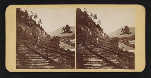
Terrace Mountain near Huntingdon, Pa
Terrace Mountain near Huntingdon, PaLibrary of Congress, Prints and Photographs Division. No known restrictions on publication. 2017660277

In September 1873 a Philadelphia stereo card publisher, James Cremer, put Terrace Mountain near Huntingdon on a nine by eighteen centimeter mount and numbered it 234. The Library of Congress record dates the card to that month, names Cremer (1821 to 1893) as both photographer and publisher, and indexes it under the subject headings mountain railroads and railroad tracks, which is as much as the record says about what is in the frame. Beyond the "near Huntingdon" of the title, its place field goes no finer than Huntingdon County, and it does not say which railroad the view shows. The card came to the library in the Marian S. Carson Collection, and the library lists no known restrictions on publication.

The mountain itself is well described in the books that cover the county. White's 1885 geological report says Terrace Mountain and Sideling Hill are the only mountains of their kind in Huntingdon County, a crest of gray Pocono sandstone above a terrace made by the hard red sandstone beds of the Catskill formation, and that this terrace is what gives the mountain its name. White wrote that the two ridges unite in a high point at the Juniata below Huntingdon and that Terrace Mountain then runs southwestward and southward past the west side of Broad Top into Bedford County. He reported that no exact measurement of its height had been made.

White also explained the crooked river at its foot. The Raystown Branch, he wrote, flows along the base of Terrace Mountain through a belt of soft Catskill rock, crossing from side to side and rebounding between ridges of Chemung sandstone on the left and the solid Pocono sandstone of Terrace Mountain on the right, so that 21 miles of air-line distance from the Bedford County line to the Juniata become nearly 50 miles of stream bed. He added that Trough Creek leaves the trough between Sideling Hill and Terrace Mountain through a gap in Terrace Mountain to reach the Raystown Branch. The 1883 county history says Trough Creek rises in Terrace Mountain, and that Forshey's Gap in the mountain took its name from the family of Solomon Forshey of Penn Township.

Cremer's label, pasted on the back of the card, advertised his shop at 18 South Eighth Street.

From James Cremer's Stereoscopic Emporium, 18 South Eighth St., Philad'a. Photo-miniatures in every style. Family groups taken for the stereoscope.Library of Congress, Historic American Buildings Survey / Historic American Engineering Record, Terrace Mountain near Huntingdon, written data pages, Library of Congress item 2017660277, photographer's label pasted on verso · character 609 of the scanned text
Checked against the record. Checked against the survey's written record before publication; 4 claims it did not support were removed or corrected.

Open this story on its own page →

Did you know? There is a furnace site on Big Trough Creek with a real claim on American industrial history.

John Savage of Philadelphia leased the furnace in 1832, renamed it Mary Ann Furnace, and built Savage Forge to work the pig iron into bar iron. The 1883 county history lists it plainly: Mary Ann Furnace and Forge, owned by John Savage, conducted by George Thompson.

The history kept by Trough Creek State Park puts the rest this way. During 1835, for the first time in the United States, good iron was produced using coke as a fuel at Mary Ann Furnace.

That is the state's own wording, and the word good is carrying weight in it. Coke had been used in American ironworks before 1835. Getting good iron out of it is the part the park claims for this spot.

The site is inside Trough Creek State Park today.

Checked against the record. CORRECTED. The core claim holds and traces to an official state source, but the original overstated it in three separate ways and one of them is a superlative in capital letters. Confirmed: PA DCNR's own Trough Creek park history says, without hedging, 'During 1835, for the first time in the United States, good iron was produced using coke as a fuel at Mary Ann Furnace.' DCNR also confirms Savage leased the furnace i…

Open this story on its own page →

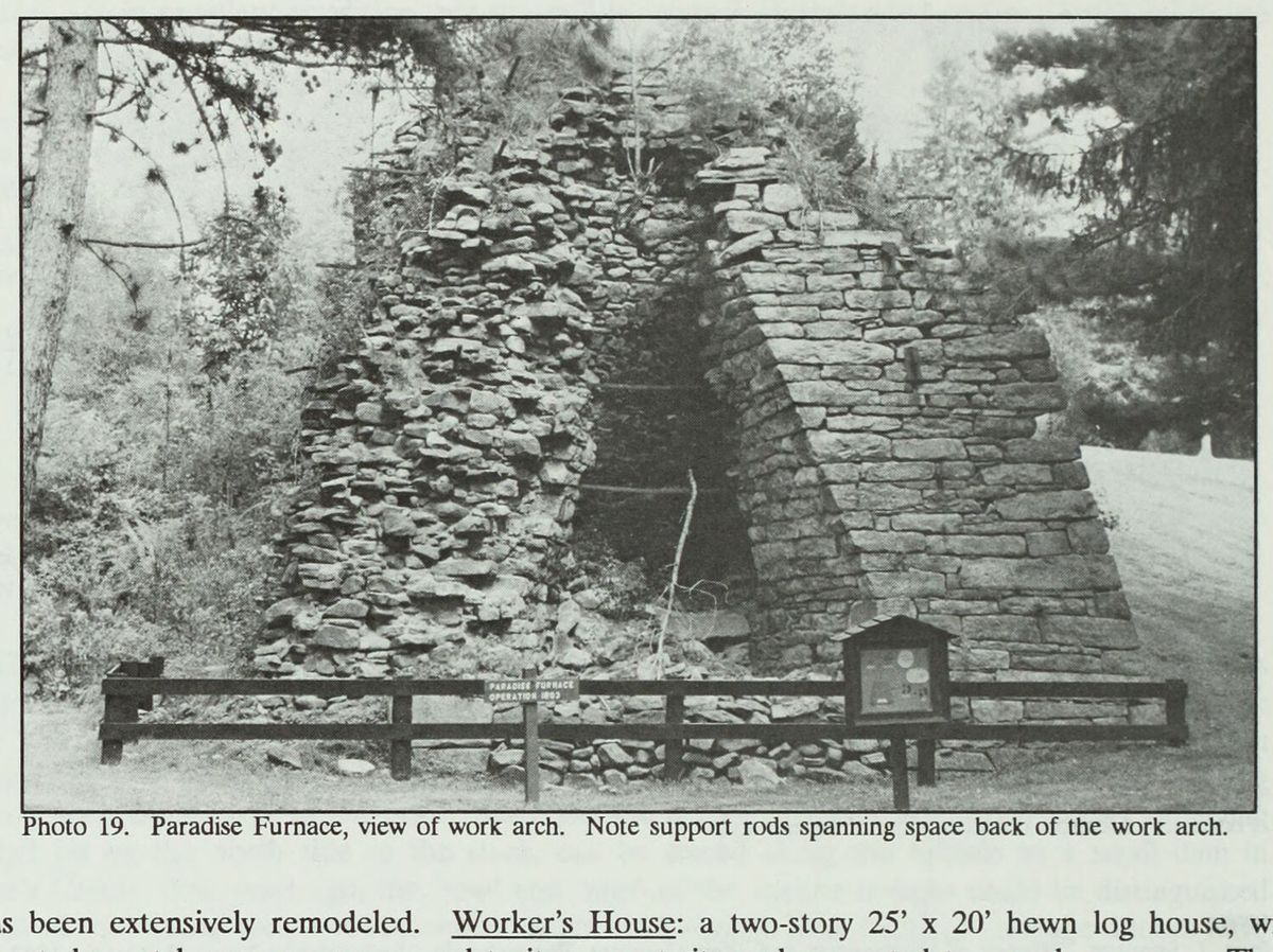
The work arch at Paradise Furnace, inside Trough Creek State Park.
The work arch at Paradise Furnace, inside Trough Creek State Park.Nancy S. Shedd et al., Huntingdon County, Pennsylvania: An Inventory of Historic Engineering and Industrial Sites (Historic American Buildings Survey / Historic American Engineering Record, National Park Service, 1991), photograph 19 shd019

Five miles southeast of Entriken, inside Trough Creek State Park, the National Register nomination counts three survivals from an iron plantation that worked Trough Creek on and off from the 1790s into the 1860s: a stone furnace stack, an ironmaster's mansion and one log house, now the park museum. The nomination, prepared in August 1989, says the works never ran steadily; they went in and out of blast as the economy turned.

The nomination traces the iron interest to about 1798, when George Knoblaugh of Frederick, Maryland, set up a bloomery near the mouth of Trough Creek. It lasted six years. In 1830 Reuben Trexler of Berks County built a furnace on the creek; it ran two years. Between 1835 and 1840 the works were revived as the Savage Iron Works and a forge was added. Then William Firmstone arrived from Shropshire, England, and tried coke made from coal out of a local mine. The nomination, citing Swank, says this was the first site in the county where coke made from Broad Top coal fueled the furnace, though not for long. Trexler had the furnace again in 1841. P.P. Dewees became its manager in 1843, and the name changed from Mary Ann to Paradise Furnace. The forge stopped in 1850 and the furnace in 1852. Horatio Trexler and Company revived the business in the 1860s, with Dewees back as manager, and the nomination's period of significance closes in 1867.

The stack, from the 1830s, is coursed rubble stone, 28 feet square and 15 to 20 feet high; the face left of the casting arch is gone, exposing the lining of the bosh. The mansion, also 1830s, is a Georgian plan house of 50 by 35 feet, five bays, its stone stuccoed and scored to look like brick.

The log house, 25 by 20 feet with inverted v-notch corners, is dated by the nomination to the late 1700s. It became the park visitor center and museum in 1982. The nomination calls it the only survival of worker housing at the site. Shedd's 1991 inventory is more careful: it says the house was moved to where it now stands and may have been a worker's house. The nomination cites a 1910 photograph of it, or one like it, that shows two front doors side by side. Those doors are gone, though the west side still shows where one was closed up.

It was the first site in the county where coke, made from Broad Top coal, was used to fuel the furnace (Swank, p. 367-68). It is also one of the few remaining examples of a once extensive industry.National Register of Historic Places nomination, Paradise Furnace (reference 90000403), Paradise Furnace, section 8, p6 · character 7,091 of the scanned text
Checked against the record. Checked against the National Register nomination text before publication; 4 claims the nomination did not support were removed or corrected.

Open this story on its own page →

A mile east of Newburg, where an unpaved township road heads toward the Rothrock State Forest, a concrete bridge carries township route 370 across Great Trough Creek. The county bridge office knows it as Huntingdon County Bridge number 14. Its name is Baker Bridge, and it was built in 1917. The nomination gives the architect and builder as unknown.

The structure is a two span concrete arch, 114 feet long. A 1991 National Park Service inventory of the county's historic engineering and industrial sites puts each arch span at about fifty feet. The nomination calls it a double rib, closed spandrel arch, a filled arch, with the space over the arches filled in beneath the roadway. The paved deck is seventeen feet wide, with metal pipe railings. The bridge sits half a mile north of Route 994, on a road the nomination describes as isolated and rural.

The nomination says Baker Bridge is one of fewer than fifteen identified concrete arch bridges erected in the region in the 1910s. The 1991 inventory, written by Nancy Shedd from the same 1988 survey the nomination draws on, puts it more loosely as one of several. The nomination places its significance in engineering, at the local level, and files it under the Industrial Resources of Huntingdon County multiple property listing. The form was prepared in September 1989 and received by the National Park Service on February 7, 1990.

The bridge had been repaired in 1978, and the nomination says the repair did not compromise its integrity. Some spalling had occurred from weather, but the bridge kept its material, its design and its setting. The nominated property is a rectangle 114 feet by 17 feet whose corners are the outside corners of the bridge's wing walls, and it takes in nothing but the bridge itself.

This two-span filled concrete-arch bridge was constructed in 1917 across Great Trough Creek. It is one of less than fifteen identified concrete arch bridges erected in the region in the 1910s.National Register of Historic Places nomination, Baker Bridge (reference 90000411), section 8, continuation page 2 (PDF page 5) · character 4,391 of the scanned text
Checked against the record. Checked against the National Register nomination text before publication; 6 claims the nomination did not support were removed or corrected.

Open this story on its own page →

Raystown Lake in late autumn, Todd township
Raystown Lake in late autumn, Todd townshipRon Shawley, via Wikimedia Commons. Creative Commons Attribution 3.0. CC BY 3.0

Todd township's first photograph here, and the lake is the reason. Raystown is the largest body of water wholly inside Pennsylvania, and its northern arms reach into this township. The photographer recorded only "Raystown lake Region late Fall"; the position saved with the file falls in Todd township, which is how it is filed here.

Open this story on its own page →

Where it sits

Alexandria borough: 12 storiesBirmingham borough: 2 storiesBroad Top City borough: 2 storiesCassville borough: 2 storiesCoalmont borough: 2 storiesDudley borough: 2 storiesHuntingdon borough: 36 storiesMapleton borough: 6 storiesMarklesburg borough: 4 storiesMill Creek borough: 4 storiesMount Union borough: 137 storiesOrbisonia borough: 8 storiesPetersburg borough: 3 storiesRockhill borough: 5 storiesSaltillo borough: 5 storiesShade Gap borough: 3 storiesShirleysburg borough: 4 storiesThree Springs borough: 4 storiesBarree township: 6 storiesBrady township: 4 storiesCarbon township: 3 storiesCass township: 2 storiesClay township: 4 storiesCromwell township: 7 storiesDublin township: 5 storiesFranklin township: 10 storiesHenderson township: 6 storiesHopewell township: 5 storiesJackson township: 9 storiesJuniata township: 8 storiesLincoln township: 5 storiesLogan township: 5 storiesMiller township: 4 storiesMorris township: 2 storiesOneida township: 6 storiesPenn township: 4 storiesPorter township: 10 storiesShirley township: 10 storiesSmithfield township: 5 storiesSpringfield township: 5 storiesSpruce Creek township: 7 storiesTell township: 3 storiesTodd township: 5 storiesUnion township: 5 storiesWalker township: 9 storiesWarriors Mark township: 5 storiesWest township: 2 storiesWood township: 13 storiesHuntingdonMount UnionOrbisoniaThree SpringsPetersburgMapletonAlexandriaRockhillBroad Top CitySaltillo
10 or more4 to 91 to 3borough outline