Huntingdon County Information Page

Township · Huntingdon County

Hopewell

5 stories on file, each with its sources. 15.3 square miles of land in the ridge and valley country of central Pennsylvania.

453
Population
2020 Census, P.L. 94-171
15.31 sq mi
Land area
2020 Census gazetteer
1.43 sq mi
Water
2020 Census gazetteer
Township
Type
GEOID 4206135688

Nearby

Straight-line miles between map centers, 2020 Census boundary file

The founding record

Hopewell township was erected in July, 1773, when the Bedford county court ordered that "that part of Barre township including all the waters that empty into the Raystown Branch of Juniata below the mouth of Yellow Creek and up said creek to Tussey's Mountain is hereby erected into a township by the name of Hopewell township." It was therefore one of the six original townships when the county was erected in 1787. John W. Jordan, ed., History of the Juniata Valley and Its People (New York: Lewis Historical Publishing, 1913) · character 188,069 of the scanned text

Quoted from a work published before 1929 and therefore in the public domain in the United States. Spelling and punctuation are as printed, including nineteenth century spellings of place names. Scanned text carries optical character recognition errors; the character offset is given so the passage can be found and checked in the original.

5 stories

Stories from Hopewell

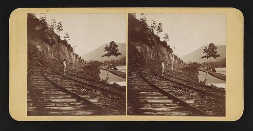
Terrace Mountain near Huntingdon, Pa
Terrace Mountain near Huntingdon, PaLibrary of Congress, Prints and Photographs Division. No known restrictions on publication. 2017660277

In September 1873 a Philadelphia stereo card publisher, James Cremer, put Terrace Mountain near Huntingdon on a nine by eighteen centimeter mount and numbered it 234. The Library of Congress record dates the card to that month, names Cremer (1821 to 1893) as both photographer and publisher, and indexes it under the subject headings mountain railroads and railroad tracks, which is as much as the record says about what is in the frame. Beyond the "near Huntingdon" of the title, its place field goes no finer than Huntingdon County, and it does not say which railroad the view shows. The card came to the library in the Marian S. Carson Collection, and the library lists no known restrictions on publication.

The mountain itself is well described in the books that cover the county. White's 1885 geological report says Terrace Mountain and Sideling Hill are the only mountains of their kind in Huntingdon County, a crest of gray Pocono sandstone above a terrace made by the hard red sandstone beds of the Catskill formation, and that this terrace is what gives the mountain its name. White wrote that the two ridges unite in a high point at the Juniata below Huntingdon and that Terrace Mountain then runs southwestward and southward past the west side of Broad Top into Bedford County. He reported that no exact measurement of its height had been made.

White also explained the crooked river at its foot. The Raystown Branch, he wrote, flows along the base of Terrace Mountain through a belt of soft Catskill rock, crossing from side to side and rebounding between ridges of Chemung sandstone on the left and the solid Pocono sandstone of Terrace Mountain on the right, so that 21 miles of air-line distance from the Bedford County line to the Juniata become nearly 50 miles of stream bed. He added that Trough Creek leaves the trough between Sideling Hill and Terrace Mountain through a gap in Terrace Mountain to reach the Raystown Branch. The 1883 county history says Trough Creek rises in Terrace Mountain, and that Forshey's Gap in the mountain took its name from the family of Solomon Forshey of Penn Township.

Cremer's label, pasted on the back of the card, advertised his shop at 18 South Eighth Street.

From James Cremer's Stereoscopic Emporium, 18 South Eighth St., Philad'a. Photo-miniatures in every style. Family groups taken for the stereoscope.Library of Congress, Historic American Buildings Survey / Historic American Engineering Record, Terrace Mountain near Huntingdon, written data pages, Library of Congress item 2017660277, photographer's label pasted on verso · character 609 of the scanned text
Checked against the record. Checked against the survey's written record before publication; 4 claims it did not support were removed or corrected.

Open this story on its own page →

Did you know? A Hopewell Township man whose father farmed at Weaver's Bridge was one of the three men who first found gold in paying quantities in the Yellowstone Valley, on August 30, 1864.

David B. Weaver was born in Hopewell Township in 1840 and brought up as a farmer. In 1863 he went to the Broad Top coal mines as weighmaster at the Crawford Colliery. In the spring of 1864 he went to Iowa, got an outfit, and crossed the plains to the gold fields of Montana, reaching Emigrant Gulch late that August.

The next summer he raised the first potatoes grown in the upper Yellowstone Valley. He mined gold for three seasons, worked as a pumping engineer at the Mount Diablo coal mines in California, and then returned to Pennsylvania.

In 1875 he was elected a Huntingdon County commissioner, on what the county history calls the first full board under the present constitution of Pennsylvania.

Checked and confirmed. CONFIRMED 2026-10-03 against the sources listed: every factual sentence was tied to a verbatim passage and a script confirmed each passage is in its source. Where sources disagreed on a number, the number was left out. Information shared with us by readers is given as theirs, not as fact: George H. Buseck.

Open this story on its own page →

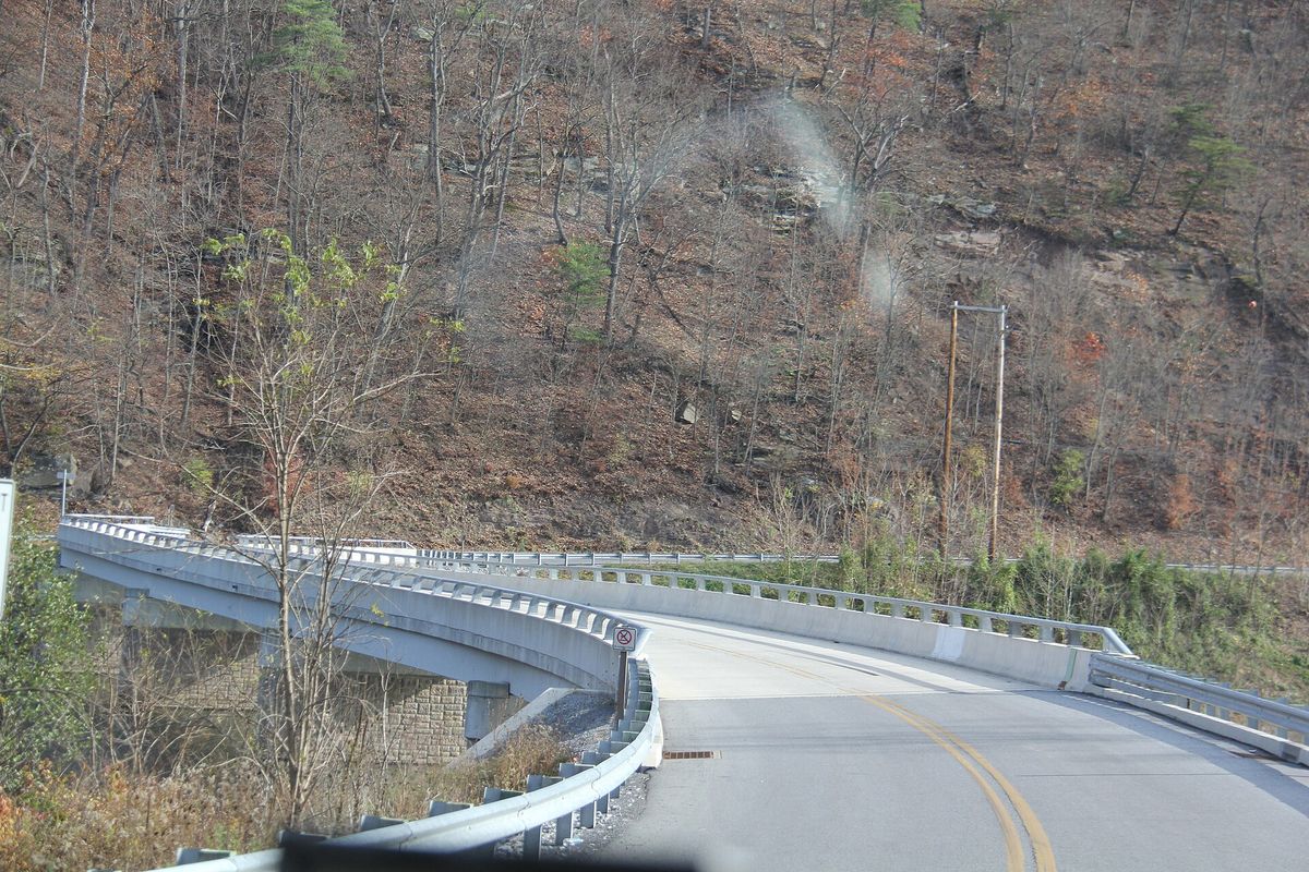
Raystown lake Region late Fall
Raystown lake Region late FallPhotograph by Ron Shawley, 8 November 2014. Licensed CC BY 3.0; reused with credit. Raystown lake Region late Fall - panoramio (64).jpg

Another frame from Ron Shawley's November 2014 run around the Raystown Lake country. He gave the whole series one caption and named no township, so this one was placed the same way the others were.

Checked against the record. Placed by the photograph's own coordinates against the Census geocoder, which returns Huntingdon / Hopewell.

Open this story on its own page →

From the county histories, on Hopewell township. The passage below is printed exactly as it appears in 1883, including the spelling of the day and the errors the scanner made. It has not been rewritten, summarised or added to.

Cook's Run rises on Broad Top Mountain, and runs southwesterly, to unite near Dudley with a small stream from the south and form Shoup's Run, which pursues a tortuous course through the southwestern part of the township, and debouches into Raystown Branch in Hopewell township. Miller's Run, Sugar Camp Run, and another stream in the western part of the township unite with Shoup's Run in its course. Highways., The most important highways in the township are one that passes from New Grenada, in Fulton County, to Robertsdale and to Broad Top City, and down the valley of Shoup's Run to Saxton, in Bedford County; another from Wells' tannery, in Fulton County, that passes northeasterly through Broad Top City and into Tod township; and two roads that lead southerly from Dudley and Coalmont respectively. The Huntingdon and Broad Top Railroad enters the township at its southwestern corner, and follows the valley of Shoup's Run to a point two miles above Dudley. The East Broad Top Railroad follows the valley of Trough Creek from the northeastern boundary of the township to Robertsdale. The coal-mines in the township are opened along the valleys of Shoup's Run and Trough Creek, where the railroads afford transportation for their products. The other portions of the township are very sparsely settled. There are two saw-mills remaining in the township, one on Sideling Hill Creek, and the other on Shoup's Run. Both are, like most of the saw-mills in this region, passing to decay.J. Simpson Africa, History of Huntingdon and Blair Counties, Pennsylvania (Philadelphia: Louis H. Everts, 1883) · character 1,487,698 of the scanned text

Open this story on its own page →

Did you know? In 1883 the only grist mill in Hopewell Township was one whose first millstones had been quarried on Broad Top Mountain.

Henry Putt built it at Puttstown in 1842. It started as a log mill with one run of stones, turned by the water of Shoup's Run. In 1853 the old log mill was taken down and a framed mill put up in its place.

Shoup's Run did other work too. A carding and cloth dressing mill on the run was turned into a tannery in 1857, and after new steam machinery came in 1882 it could handle two thousand five hundred hides a year.

Checked and confirmed. CONFIRMED 2026-10-03 against the sources listed: every factual sentence was tied to a verbatim passage and a script confirmed each passage is in its source. Where sources disagreed on a number, the number was left out.

Open this story on its own page →

Where it sits

Alexandria borough: 12 storiesBirmingham borough: 2 storiesBroad Top City borough: 2 storiesCassville borough: 2 storiesCoalmont borough: 2 storiesDudley borough: 2 storiesHuntingdon borough: 36 storiesMapleton borough: 6 storiesMarklesburg borough: 4 storiesMill Creek borough: 4 storiesMount Union borough: 137 storiesOrbisonia borough: 8 storiesPetersburg borough: 3 storiesRockhill borough: 5 storiesSaltillo borough: 5 storiesShade Gap borough: 3 storiesShirleysburg borough: 4 storiesThree Springs borough: 4 storiesBarree township: 6 storiesBrady township: 4 storiesCarbon township: 3 storiesCass township: 2 storiesClay township: 4 storiesCromwell township: 7 storiesDublin township: 5 storiesFranklin township: 10 storiesHenderson township: 6 storiesHopewell township: 5 storiesJackson township: 9 storiesJuniata township: 8 storiesLincoln township: 5 storiesLogan township: 5 storiesMiller township: 4 storiesMorris township: 2 storiesOneida township: 6 storiesPenn township: 4 storiesPorter township: 10 storiesShirley township: 10 storiesSmithfield township: 5 storiesSpringfield township: 5 storiesSpruce Creek township: 7 storiesTell township: 3 storiesTodd township: 5 storiesUnion township: 5 storiesWalker township: 9 storiesWarriors Mark township: 5 storiesWest township: 2 storiesWood township: 13 storiesHuntingdonMount UnionOrbisoniaThree SpringsPetersburgMapletonAlexandriaRockhillBroad Top CitySaltillo
10 or more4 to 91 to 3borough outline