Todd township, Penn township, Lincoln township, Union township, Hopewell township, Juniata township
Terrace Mountain on a Philadelphia stereo card, 1873
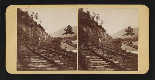
In September 1873 a Philadelphia stereo card publisher, James Cremer, put Terrace Mountain near Huntingdon on a nine by eighteen centimeter mount and numbered it 234. The Library of Congress record dates the card to that month, names Cremer (1821 to 1893) as both photographer and publisher, and indexes it under the subject headings mountain railroads and railroad tracks, which is as much as the record says about what is in the frame. Beyond the "near Huntingdon" of the title, its place field goes no finer than Huntingdon County, and it does not say which railroad the view shows. The card came to the library in the Marian S. Carson Collection, and the library lists no known restrictions on publication.
The mountain itself is well described in the books that cover the county. White's 1885 geological report says Terrace Mountain and Sideling Hill are the only mountains of their kind in Huntingdon County, a crest of gray Pocono sandstone above a terrace made by the hard red sandstone beds of the Catskill formation, and that this terrace is what gives the mountain its name. White wrote that the two ridges unite in a high point at the Juniata below Huntingdon and that Terrace Mountain then runs southwestward and southward past the west side of Broad Top into Bedford County. He reported that no exact measurement of its height had been made.
White also explained the crooked river at its foot. The Raystown Branch, he wrote, flows along the base of Terrace Mountain through a belt of soft Catskill rock, crossing from side to side and rebounding between ridges of Chemung sandstone on the left and the solid Pocono sandstone of Terrace Mountain on the right, so that 21 miles of air-line distance from the Bedford County line to the Juniata become nearly 50 miles of stream bed. He added that Trough Creek leaves the trough between Sideling Hill and Terrace Mountain through a gap in Terrace Mountain to reach the Raystown Branch. The 1883 county history says Trough Creek rises in Terrace Mountain, and that Forshey's Gap in the mountain took its name from the family of Solomon Forshey of Penn Township.
Cremer's label, pasted on the back of the card, advertised his shop at 18 South Eighth Street.
From James Cremer's Stereoscopic Emporium, 18 South Eighth St., Philad'a. Photo-miniatures in every style. Family groups taken for the stereoscope.Library of Congress, Historic American Buildings Survey / Historic American Engineering Record, Terrace Mountain near Huntingdon, written data pages, Library of Congress item 2017660277, photographer's label pasted on verso · character 609 of the scanned text
Sources
- Library of Congress, Prints and Photographs Division, item 2017660277: Terrace Mountain near Huntingdon, Pa. (stereograph, James Cremer's Stereoscopic Emporium, Sep 1873)
- LOC item record fields for 2017660277 (data pages, D:/Projects/HuntCo/_scratch/newstories/habs/data/2017660277.txt) (1873)
- White 1885, The Geology of Huntingdon County (Second Geological Survey of Pennsylvania, Report of Progress T3)
- Africa 1883, History of Huntingdon and Blair Counties
Checked 2026-09-05 · Library of Congress survey record, read in full
← All stories from Todd township
Have something to add to this story, or a photograph of it? Send it here →
Photographs from Todd township
More from Todd township
Did you know? There is a furnace site on Big Trough Creek with a real claim on American industrial history. John…
Todd township, Paradise Furnace, the iron plantation inside Trough Creek State ParkFive miles southeast of Entriken, inside Trough Creek State Park, the National Register nomination counts three…
Todd township, Baker Bridge, a 1917 concrete arch over Great Trough CreekA mile east of Newburg, where an unpaved township road heads toward the Rothrock State Forest, a concrete bridge…
Also about photographs