Mount Union borough
Drake's Ferry Before the Bridges
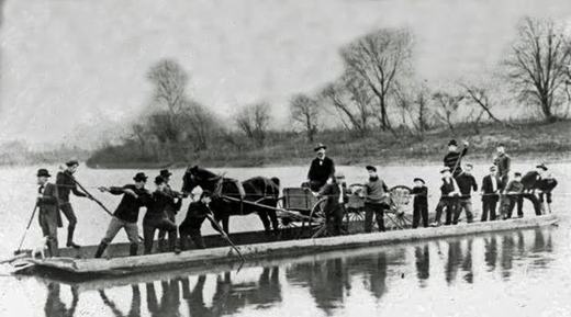
Before every bridge there was a ferry, and this one carried the road that made the town.
Samuel Drake, Sr., a New Jersey man who had served in the Revolution, established Drake's Ferry in 1783 at the east end of Jack's Narrows just west of town. The tavern and stables stood on the north side of the river, just west of where the county bridge is now. It was, says the Juniata Valley encyclopedia, the only crossing over the Juniata provided for the travelling public on the great thoroughfare from Standing Stone, now Huntingdon, to Chambersburg, Hagerstown, Harper's Ferry and Baltimore. That was the principal route of traffic in the first quarter of the nineteenth century, and it had begun as an Indian trail used afterwards by traders and wagoners. Travellers generally arrived in the evening and left in the morning, so the tavern got a night out of every crossing.
The road to it was laid out by order of the court at Bedford. Six viewers reported in April 1787 that they had run a public road from the Burnt Cabins to Drake's Ferry, twenty four miles and forty nine perches, through what is now Dublin, Cromwell and Shirley townships. One of the six signed with his mark.
What ended the ferry was not the railroad. It was the canal. Welch, writing in the town in 1909, says the ferry flourished before the canal was built, and the 1897 encyclopedia is exact about it: the ferry was operated for many years, and not until the building of the canal, about the year 1830, was it abandoned.
The best part is what became of the ferryman. James Drake, Samuel's eldest son, was born at the ferry in 1787 and lived there until it was abandoned. He helped with the work until he was old enough to take charge, and ran it himself until about 1830, when the construction of the canal through the Narrows took place, of which he was the first foreman. The man who lost the ferry built the thing that ended it. He then moved out to the farm and put up the log house at the forks of the road at the mouth of Long Hollow.
The published account of the canal's opening picked out this spot above all others: the sublime and romantic scenery, particularly at Drake's Ferry, “is not excelled in any part of Pennsylvania.”
A railroad was supposed to come here too. Meetings were held along the proposed route early in 1848, one of them at Scottsville on 28 February, and on 25 March the legislature passed an act incorporating the Drake's Ferry and East Broad Top Railroad Company. No steps were ever taken to build it. Mount Union was laid out in 1850 by George W. Speer and John Dougherty, designed as the place where that railroad, which did not exist, would transfer to the canal, which was already finished. The town was planned around a junction of two things, and one of them was never built.
From the record
Passages about this subject, quoted from county histories now in the public domain. Each one names the book and the position in the text so it can be checked. Spelling is as printed.
Mount Union was laid out in 1850, by Gen. George W. Speer and John Dougherty, and was designed by the proprietors as a place of transfer from their contemplated Drake's Ferry and East Broad Top Railroad, for which a charter was granted by the Legislature in 1819, to the Pennsylvania canal. The name, Mount Union, concentrates the physical, geological, commercial, mineral and manufacturing features of a wild and beautiful region. The East Broad Top railroad intersects the Pennsylvania railroad at Mount Union and has added five hundred tons of coal and forty tons of pig-metal daily to the tonnage of the latter. This will be more than doubled when a branch railway of two and a-half miles into the Rocky ridge coal basin and a dozen miles to the iron mines of Fulton county, shall be built. From a letter written by John Dougherty, esq., to Prof. Dewees, of the State Geological Survey, on the 28th day of January, 1875, giving a sketch of the history of Matilda Furnace, opposite Mount Union, in Mifflin county, we take the following extract in relation to the iron ores of the southern part of Huntingdon county, from the Juniata river to Fort Littleton: " In the vicinity of Mount Union, fossil ore yielding 40 per cent, of iron can be mined in slopes of 500 to 700 feet above water level.Milton Scott Lytle, History of Huntingdon County (Lancaster: William H. Roy, 1876) · character 532,034 of the scanned text
Is o steps were ever taken towards the construction of this road. HISTORY OF HUNTINGDON" COUNTY. 155 The ground is now occupied by the East Broad Top Railroad and Coal Company. The latter corporation was organized under an act of Assembly of April 16th, 1856. The persons most actively engaged in the organization of the company were Messrs. Edward Roberts, A. Pardee and J. G. Fell, assisted in the vicinity of the road by Wm. B. Leas, Samuel McVitty, Dr. Louis Royer, P. P. Dewees and others. Work was commenced Sept. 16th, 1872, and the road opened for business as far as Orbisonia, a distance of 11 miles, Aug. 30th, 1873, and to Robertsdale, the terminus of the road, on Nov. 4th, '74. The road is 30 miles long , 3 ft. gauge. The northern terminus is Mount Union on the Pa. R. R., then running in a southern direction through or near the following towns or villages in the order named- Shirleysburg, Orbisonia, Three Springs, Saltillo and Cooks Mills, terminating at the Broad Top coal fields at Robertsdale. The first officers of the corporation were, President, Wm. Directors, Edward Roberts, A. Pardee, J. G. Fell, Percival Roberts, Randolph Wood, and C. R. Wood. Secretary, Percival Roberts ; engineer, John B. Wingate. The latter gentleman was obliged to resign on account of failing health, and was succeeded by A. W.Milton Scott Lytle, History of Huntingdon County (Lancaster: William H. Roy, 1876) · character 298,782 of the scanned text
The East Broad Top railroad connects with the Pennsylvania railroad at Mount Union and runs south through Shirleysburg, giving the township and outlying region ample transportation facilities. Smithiield is one of the newer townships of the county, having been organized in March, 1886, from Porter, Walker, and Juniata. It lies directly across the Juniata river from Huntingdon borough, the village of Smithfield forming practically a suburb of the county seat. The Huntingdon & Broad Top railroad runs southwest through the township. Springfield township, located in the southern part of the county, was organized in December, 1790, from the townships of Dublin and Shirley. Its original area has been much reduced by the erection of Cromwell in 1836 and Clay in 1845. It is bounded on the north by Cromwell ; on the east by Dublin ; on the south by Fulton county, and on the west by the township of Clay. John Bailey, a Revolutionary soldier, settled on the banks of the Aughwick creek soon after that war. He was soon joined by William Jones, John Robertson and William Ward. Then came a tide of immigration from Maryland, the Browns, Maddens, Ramseys, Lanes, Cutshalls, Wibles, and several other families locating in what is now Springfield township.John W. Jordan, ed., History of the Juniata Valley and Its People (New York: Lewis Historical Publishing, 1913) · character 200,880 of the scanned text
Sources
- Commemorative Biographical Encyclopedia of the Juniata Valley, volume 1, 1897: the ferry “was operated for many years, and not until the building of the canal, about the year 1830, was it abandoned”, and James Drake as the canal's first foreman, J. M. Runk & Co., Chambersburg
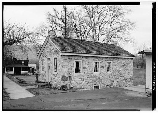
- History of Mount Union, Shirleysburg and Shirley Township, 1909: Drake's Ferry “flourished before the canal was built”, and the account of the stone house being struck by a train, Charles Howard Welch, Mount Union, Pa.
- History of Huntingdon and Blair Counties, Pennsylvania, 1883: the 1787 road from Burnt Cabins to Drake's Ferry, Col. Pollock's stone house and the naming of Mount Union, and the published account of the canal's opening, J. Simpson Africa (Louis H. Everts, Philadelphia)
- History of Huntingdon County, 1876, chapter XIX: the Scottsville meeting of 28 February 1848, the act of 25 March incorporating the Drake's Ferry and East Broad Top Railroad Company, and Mount Union laid out in 1850 as a transfer point, Milton Scott Lytle
- A History of the Juniata Valley and its People, volume 1, 1913, page 91: the charter for the Drake's Ferry and East Broad Top railroad and the stone house “subsequently destroyed by fire”, John W. Jordan
Checked 2026-09-10 · Historic Mount Union collection
← All stories from Mount Union borough
Have something to add to this story, or a photograph of it? Send it here →
Photographs from Mount Union borough
More from Mount Union borough
Did you know? The crossing at Drake's Ferry, just above Mount Union, went from a ferry to a series of bridges. Samuel…
Mount Union borough, The darkest day: February 27, 1917February 27, 1917, eight minutes past midnight. The eastbound Mercantile Express, Pennsylvania Railroad train No. 6 out…
Mount Union borough, A Question We Cannot Settle, and Maybe You CanThis stone house stands on West Water Street near Division. The federal survey records it as the John Sharrar House and…