Huntingdon County Information Page

Township · Huntingdon County

Penn

4 stories on file, each with its sources. 28.6 square miles of land in the ridge and valley country of central Pennsylvania.

1,077
Population
2020 Census, P.L. 94-171
28.62 sq mi
Land area
2020 Census gazetteer
5.95 sq mi
Water
2020 Census gazetteer
Township
Type
GEOID 4206158832

Nearby

Straight-line miles between map centers, 2020 Census boundary file

The founding record

Penn township, near the southeastern corner of the county, is triangular in form and is bounded on the north by Wheatfield township ; on the east by the Juniata and Susquehanna rivers ; on the south by Rye township, and a little of the western boundary at the apex of the triangle is formed by Carroll. It was taken from Rye by order of the court in 1826. The first settlement made in this part of Perry county was that made by John Harris about 1732 and was located near the present railroad station called Aqueduct. About 1753 several persons came up the Susquehanna and settled along the Juniata river on both sides, and on Duncan's island, which now forms part of Watts township. Among those who located in Penn township were James Baskins, Cornelius Acheson, and Francis Ellis. James Baskins was the founder of the historic Baskins' ferry at the foot of Haldeman island, about which the settlement known as Baskinsville grew up in course of time. Samuel Goudy warranted 215 acres of land in August, 1766, but afterward sold it to John Clark, who established Clark's ferry and also built a tavern there. The tavern became a well-known stopping place after the Juniata Stage Company began operations in 1808. Above James Baskins' place were the Barren Hills, where William Baskins took up 300 acres in 1766. John W. Jordan, ed., History of the Juniata Valley and Its People (New York: Lewis Historical Publishing, 1913) · character 522,719 of the scanned text
Penn is bounded on the north by the townships of Walker and Juniata, on the east by Union, Cass, and Tod, on the south by Lincoln, and on the west by the county of Blair, the summits of Terrace and Tussey's Mountains forming respectively the eastern and western boundary lines, In area the township is about six miles from north to south, and eight from east to west. It is watered by the Raystown Branch of the Juniata, which runs along the foot of Terrace Mountain. James Creek and its tributaries and some of the tributaries of Crooked Creek also traverse the township. The surface of the country is broken by numerous 1By J. À. Wintrode, M.D, ridges, which at some points assume the proportions of mountains, the principal ones being Redstone, Mulberry, Warrior's, Backbone, Piney, and Alagrippa, or * Allegrippus." Woodcock Valley embraces the territory lying between Warrior's Ridge and Tussey's Mountain. Although somewhat broken, it is naturally a very productive limestone soil, and most of it is in a high state of cultivation. The slate soil of "the ridges" is less productive than that of the valley, but in favorable seasons produces excellent crops. The soil of the valley of the Raystown Branch. is mainly a sandy alluvium, and is also highly productive. Penn is rich in iron ores.J. Simpson Africa, History of Huntingdon and Blair Counties, Pennsylvania (Philadelphia: Louis H. Everts, 1883) · character 2,172,448

Quoted from a work published before 1929 and therefore in the public domain in the United States. Spelling and punctuation are as printed, including nineteenth century spellings of place names. Scanned text carries optical character recognition errors; the character offset is given so the passage can be found and checked in the original.

4 stories

Stories from Penn

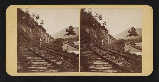
Terrace Mountain near Huntingdon, Pa
Terrace Mountain near Huntingdon, PaLibrary of Congress, Prints and Photographs Division. No known restrictions on publication. 2017660277

In September 1873 a Philadelphia stereo card publisher, James Cremer, put Terrace Mountain near Huntingdon on a nine by eighteen centimeter mount and numbered it 234. The Library of Congress record dates the card to that month, names Cremer (1821 to 1893) as both photographer and publisher, and indexes it under the subject headings mountain railroads and railroad tracks, which is as much as the record says about what is in the frame. Beyond the "near Huntingdon" of the title, its place field goes no finer than Huntingdon County, and it does not say which railroad the view shows. The card came to the library in the Marian S. Carson Collection, and the library lists no known restrictions on publication.

The mountain itself is well described in the books that cover the county. White's 1885 geological report says Terrace Mountain and Sideling Hill are the only mountains of their kind in Huntingdon County, a crest of gray Pocono sandstone above a terrace made by the hard red sandstone beds of the Catskill formation, and that this terrace is what gives the mountain its name. White wrote that the two ridges unite in a high point at the Juniata below Huntingdon and that Terrace Mountain then runs southwestward and southward past the west side of Broad Top into Bedford County. He reported that no exact measurement of its height had been made.

White also explained the crooked river at its foot. The Raystown Branch, he wrote, flows along the base of Terrace Mountain through a belt of soft Catskill rock, crossing from side to side and rebounding between ridges of Chemung sandstone on the left and the solid Pocono sandstone of Terrace Mountain on the right, so that 21 miles of air-line distance from the Bedford County line to the Juniata become nearly 50 miles of stream bed. He added that Trough Creek leaves the trough between Sideling Hill and Terrace Mountain through a gap in Terrace Mountain to reach the Raystown Branch. The 1883 county history says Trough Creek rises in Terrace Mountain, and that Forshey's Gap in the mountain took its name from the family of Solomon Forshey of Penn Township.

Cremer's label, pasted on the back of the card, advertised his shop at 18 South Eighth Street.

From James Cremer's Stereoscopic Emporium, 18 South Eighth St., Philad'a. Photo-miniatures in every style. Family groups taken for the stereoscope.Library of Congress, Historic American Buildings Survey / Historic American Engineering Record, Terrace Mountain near Huntingdon, written data pages, Library of Congress item 2017660277, photographer's label pasted on verso · character 609 of the scanned text
Checked against the record. Checked against the survey's written record before publication; 4 claims it did not support were removed or corrected.

Open this story on its own page →

Did you know a governor of Pennsylvania was teaching in this county's one-room schools before he was old enough to vote?

Martin Grove Brumbaugh was born in Penn township on 14 April 1862, son of George B. and Martha P. Brumbaugh of Marklesburg. The family had been here a long while: his great-grandfather Jacob bought land in Woodcock Valley and lived out his life on it, and a remote ancestor, Hans Heinrich Brumbaugh, had come from Germany in the first half of the seventeen hundreds.

He taught country schools in 1877 and 1878. He was fifteen. He graduated from Juniata College in 1881, studied at Millersville, taught at his own college until 1884, and was then elected county superintendent of schools, re-elected in 1887, six years in the post.

Then he kept going: a post-graduate year at Howard University from 1890, then the University of Pennsylvania.

He was governor of Pennsylvania from 1915 to 1919, right through the war.

Checked against the record. SOURCE UPGRADED from Wikipedia to two books already in this project's corpus, which is where this should have been checked first. CONFIRMED, Commemorative Biographical Encyclopedia of the Juniata Valley, 1897 - a contemporary account written while he was still a young man: "Martin Grove Brumbaugh, Huntingdon, Pa., was born in Penn township, Huntingdon county, April 14, 1862, son of George B. and Martha P. Brumbaugh,…

Read the full story, with 3 passages quoted from the county histories →

Half a mile southeast of the junction of Township Route 419 with Route 26, at the spillway crest of Raystown Lake, the nomination placed a stone farmhouse that the Brumbaugh family held for about 175 years. When the United States Army Corps of Engineers nominated it to the National Register in 1977 the Corps owned it, and the form listed it under a second name, Timothy Meadows Farm.

The nomination dates the stone section to 1804 and says Jacob Brumbaugh built it, probably with major effort from his son George. Its moldings and chair rails are in plain early Federal style. A brick wing and a vertical plank wing were added before the 1860s, and the family spoke of the "stone house," the "brick house" and the "plank house" as if they were separate houses. The nomination says the brick wing was built by a grandson, also named Jacob, who later recorded an agreement with his son Abraham dividing the house between them.

What sets the house apart is a set of hinged partitions on the first floor. Sections of the board walls could swing back to throw the floor into one large room, and the nomination says the house may have been used for church services. The Brumbaughs were leaders of the German Baptist Brethren, a church that used lay leaders rather than a paid ministry and held services in members' homes. The nomination says George and his son Isaac served in turn as elders and overseers of the James Creek congregation, later the Church of the Brethren, before it built a brick church in 1860 to seat more than 200. Africa's 1883 county history names both men among the early elders of the Brethren there, calls George a minister and a bishop in the church, and says he occupied the homestead until his death on August 6, 1849.

The nomination names Dr. Martin G. Brumbaugh, governor of Pennsylvania and commissioner of education in Puerto Rico, as a member of the family, and says several generations lived in the house at one time up to the 1960s. The property was entered in the National Register on March 28, 1979, for its architecture and as an early settler homestead that doubled as a church.

One panel of the old folding partition, about six feet by six feet, was still visible inside when the form was written, nailed shut and covered for approximately 80 years.

Thus, the Brumbaugh House was both home and church, and the men of the family were both farmers and ministers.National Register of Historic Places nomination, Brumbaugh Homestead (reference 79002236), 79002236, p. 17 · character 18,169 of the scanned text
Checked against the record. Checked against the National Register nomination text before publication; 6 claims the nomination did not support were removed or corrected.

Open this story on its own page →

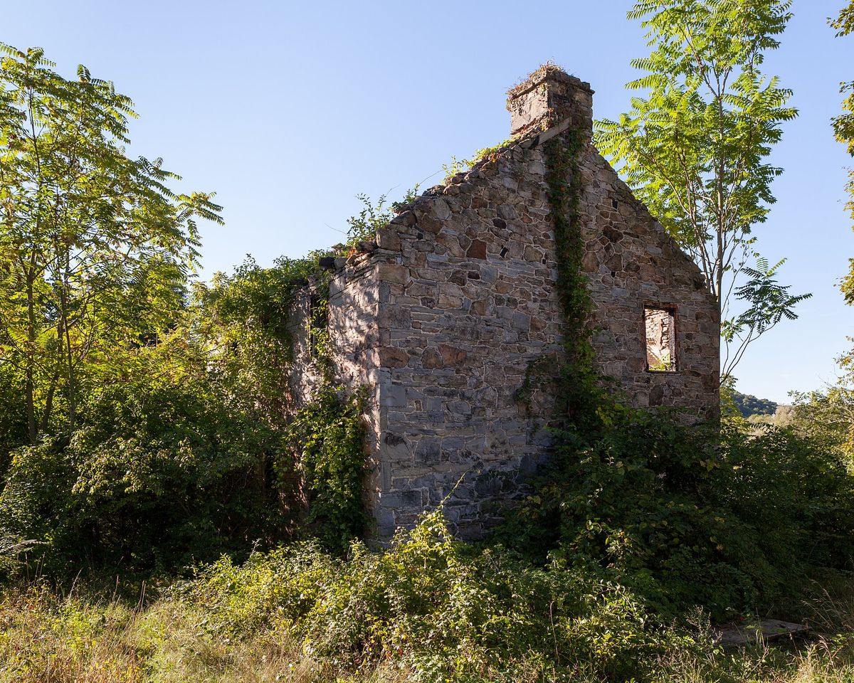
Ruins of the Brumbaugh Homestead, looking at the north and east sides.
Ruins of the Brumbaugh Homestead, looking at the north and east sides.Photograph by Generic1139, 2014-09-07. Licensed CC BY-SA 3.0; reused with credit, and the same licence travels with any derivative. Brumbaugh Homestead east and north.jpg

What remains of the Brumbaugh homestead in Penn township, photographed from the north and east in September 2014.

Checked against the record. Placed by the photograph's own coordinates against the Census geocoder, which returns Huntingdon / Penn.

Open this story on its own page →

Where it sits

Alexandria borough: 12 storiesBirmingham borough: 2 storiesBroad Top City borough: 2 storiesCassville borough: 2 storiesCoalmont borough: 2 storiesDudley borough: 2 storiesHuntingdon borough: 36 storiesMapleton borough: 6 storiesMarklesburg borough: 4 storiesMill Creek borough: 4 storiesMount Union borough: 137 storiesOrbisonia borough: 8 storiesPetersburg borough: 3 storiesRockhill borough: 5 storiesSaltillo borough: 5 storiesShade Gap borough: 3 storiesShirleysburg borough: 4 storiesThree Springs borough: 4 storiesBarree township: 6 storiesBrady township: 4 storiesCarbon township: 3 storiesCass township: 2 storiesClay township: 4 storiesCromwell township: 7 storiesDublin township: 5 storiesFranklin township: 10 storiesHenderson township: 6 storiesHopewell township: 5 storiesJackson township: 9 storiesJuniata township: 8 storiesLincoln township: 5 storiesLogan township: 5 storiesMiller township: 4 storiesMorris township: 2 storiesOneida township: 6 storiesPenn township: 4 storiesPorter township: 10 storiesShirley township: 10 storiesSmithfield township: 5 storiesSpringfield township: 5 storiesSpruce Creek township: 7 storiesTell township: 3 storiesTodd township: 5 storiesUnion township: 5 storiesWalker township: 9 storiesWarriors Mark township: 5 storiesWest township: 2 storiesWood township: 13 storiesHuntingdonMount UnionOrbisoniaThree SpringsPetersburgMapletonAlexandriaRockhillBroad Top CitySaltillo
10 or more4 to 91 to 3borough outline